Illinois Route 2
Illinois Route 2 (IL 2) is a north–south state road in northern Illinois. It currently starts at Illinois Route 40 in Sterling and ends at the Wisconsin state line in South Beloit, very near the intersection with U.S. Route 51, Illinois Route 75 and Illinois Route 251.[3] Illinois 2 is 73.91 miles (118.95 km) long.[1]
| ||||
|---|---|---|---|---|

IL 2 highlighted in red | ||||
| Route information | ||||
| Maintained by IDOT | ||||
| Length | 73.91 mi[1] (118.95 km) | |||
| Existed | November 5, 1918[2]–present | |||
| Major junctions | ||||
| South end | ||||
| North end | ||||
| Location | ||||
| Counties | Whiteside, Lee, Ogle, Winnebago | |||
| Highway system | ||||
| ||||

Route description
Illinois 2 follows the Rock River from Rock Island to South Beloit. It was used in the 19th century as a primary trading route from Rockford to Rock Island, The Rock River was not used as a trading route for boats as it is only navigable west of Rock Falls.
Illinois 2 has since been superseded by Interstate 39 and Interstate 88 for most ground transportation, but the original route remains.
History
SBI Route 2 originally ran from South Beloit to Cairo. Part of the roadway followed the original IL 2 from South Beloit to Dixon. It then followed south on (roughly) present-day US 52, IL 251, and US 51.[4] In 1936, IL 2 was removed south of Dixon.[5] In the late 1930s, IL 2 was extended to Rock Island.[6] By the late 1970s, IL 2 was removed west of Sterling as Illinois Route 5 (now I-88 east of I-80) was extended to Rock Island.[7]
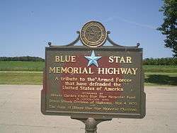
Blue Star Memorial Highway
Illinois 2 was designated a Blue Star Memorial Highway on November 4, 1970. The sign can be found in a wayside just west of the Winnebago County line in Ogle County along the Rock River.
.
Major intersections
| County | Location | mi[1][8] | km | Destinations | Notes |
|---|---|---|---|---|---|
| Whiteside | Sterling | 0.0 | 0.0 | ||
| South end of Lincoln Highway overlap | |||||
| Freeport Road - Polo | State maintained (outside Sterling) | ||||
| | North end of Lincoln Highway overlap; state maintained | ||||
| Lee | | South end of Lincoln Highway overlap; state maintained | |||
| Dixon | 12.3 | 19.8 | South end of US 52 / IL 26 overlap | ||
| 12.7 | 20.4 | North end of US 52 / IL 26 / Lincoln Highway overlap | |||
| Ogle | Oregon | 28.6 | 46.0 | ||
| | 37.9 | 61.0 | South end of IL 72 overlap | ||
| Byron | 39.2 | 63.1 | North end of IL 72 overlap | ||
| Winnebago | | 50.6 | 81.4 | Interchange | |
| Rockford | One-block overlap with US 20 Bus. east, northbound only | ||||
| Rockton | 69.1 | 111.2 | South end of IL 75 overlap | ||
| South Beloit | 71.4 | 114.9 | North end of IL 75 overlap | ||
| 71.6 | 115.2 | Wisconsin state line | |||
1.000 mi = 1.609 km; 1.000 km = 0.621 mi
| |||||
References
- Illinois Technology Transfer Center (2007). "T2 GIS Data". Retrieved 2007-11-08.
- Carlson, Rick. Illinois State Highways Page: Routes 1 thru 20. Last updated March 15, 2006. Retrieved March 24, 2006.
- Illinois Highway Ends. Illinois 2 Archived 2012-03-09 at the Wayback Machine. Retrieved May 2, 2006.
- Illinois Secretary of State; H.M. Gousha (1928). Illinois Official Auto Road Map (Map). [c. 1:950,000 and c. 1:1,110,000]. Springfield: Illinois Secretary of State – via Illinois Digital Archives.
- Illinois Secretary of State; Rand McNally (1936). Road Map Illinois (Map). [c. 1:950,000 and c. 1:1,110,000]. Springfield: Illinois Secretary of State – via Illinois Digital Archives.
- Illinois Secretary of State; Rand McNally (1939). Illinois Road Map (Map) (1939–1940 ed.). c. 1:918,720. Springfield: Illinois Secretary of State – via Illinois Digital Archives.
- Illinois Department of Transportation (1979). Illinois Highway Map (Map). [1:772,500]. Springfield: Illinois Department of Transportation – via Illinois Digital Archives.
- Google Maps estimate