Illinois Route 3
Illinois Route 3 (IL 3) is a 187.44-mile-long (301.66 km) major north–south arterial state highway in southwestern Illinois. It has its southern terminus at Cairo Junction (about four miles (6.4 km) north of Cairo) at the intersection of U.S. Route 51 (US 51) and Illinois Route 37 (IL 37), and its northern terminus in Grafton at IL 100.
| ||||
|---|---|---|---|---|
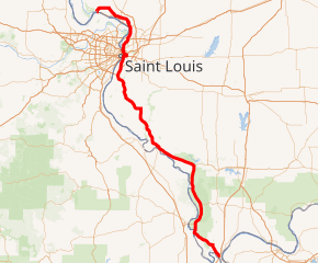
IL 3 highlighted in red | ||||
| Route information | ||||
| Maintained by IDOT | ||||
| Length | 187.44 mi[1] (301.66 km) | |||
| Existed | November 5, 1918[2]–present | |||
| Major junctions | ||||
| South end | ||||
| North end | ||||
| Location | ||||
| Counties | Alexander, Union, Jackson, Randolph, Monroe, St. Clair, Madison, Jersey | |||
| Highway system | ||||
| ||||

Route description
The majority of IL 3 has four lanes from Waterloo to Godfrey, with a brief six-lane stretch from the entrance to the McKinley Bridge in Venice to near the River's Edge area (formerly the Army Depot of Granite City) and around Alton, and a brief two-laned section between its separation from I-55, I-64, and US 40 in East St. Louis and Venice. It is also two-laned the majority of the southern part from Waterloo to Mound City around the Shawnee National Forest Area. It briefly overlaps IL 111 at Alton, I-255 and US 50, and IL 127 north of Cache.
IL 3 parallels the Mississippi River for the entire length of its journey, and it carries the Illinois portion of the Great River Road for most of its length. South of St. Louis, I-55 is its parallel on the west side of the river, along with US 61. The road runs along many historical sites along the Mississippi River, and is the closest Illinois state highway to the old state capital of Kaskaskia.
History
Original 1918 route
The original IL 3 route went from Chester in southern Illinois to Morrison in northwest Illinois via Rock Island. With the completion of highway bridges over the Mississippi River (e.g. Clark Bridge at Alton) U.S. Route 67 (US 67) was extended from St. Louis to Godfrey and replaced the original IL 3 to Rock Island. Today, this route is still the major north–south corridor for western Illinois—and the only major Illinois north–south route never upgraded to the Interstate Highway System like I-57, I-55, or I-39.
Current route
On August 4, 1976, the new Berm Highway from Wood River to Alton was opened.[3] It was signed as IL 3, which left the old alignment on Lewis and Clark Boulevard and Broadway unmarked. However, on June 29, 1987, the Illinois Department of Transportation (IDOT) built the new Madison Avenue extension in Wood River and marked that road and the Berm Highway as IL 143[4] and truncated IL 3 at IL 143 (highway signage and IDOT planning maps suggested otherwise, however). This new terminus for Route 3 was short-lived, however.
On November 26, 1987, a new section of Homer M. Adams Parkway in Alton opened to traffic, and IL 3 was extended onto Lewis and Clark Boulevard (a former IL 3 alignment) back into Alton and onto the extension. IL 3 was then cosigned with IL 111 until the intersection with Godfrey Road, where IL 3 takes over the former IL 100 alignment.[5]
Major intersections
| County | Location | mi[1][6] | km | Exit | Destinations | Notes |
|---|---|---|---|---|---|---|
| Alexander | Cairo | 0.0 | 0.0 | Southern end of US 51/Great River Road/Lincoln Heritage Trail overlap | ||
| 0.8 | 1.3 | Northern end of US 51 overlap; I-57 exit 1 | ||||
| Olive Branch | Horseshoe Lake Conservation Area, Miller City | |||||
| Thebes | Thebes Road - Thebes, Thebes Historical Courthouse | |||||
| | 8.5 | 13.7 | ||||
| McClure | 26.0 | 41.8 | Southern end of IL 146 overlap | |||
| Union | Ware | 37.7 | 60.7 | Northern end of IL 146 overlap | ||
| Jackson | Grand Tower | 51.3 | 82.6 | |||
| | 53.0 | 85.3 | ||||
| | Gorham Road - Gorham, Neunert, Jacob | state maintained | ||||
| | Town Creek Road - Sandridge, Little Grand Canyon | |||||
| | 60.6 | 97.5 | ||||
| | 65.0 | 104.6 | ||||
| Randolph | | 80.6 | 129.7 | Northern end of Great River Road overlap; state maintained | ||
| Chester | 83.4 | 134.2 | Southern end of IL 150 overlap | |||
| 83.6 | 134.5 | Northern end of IL 150 overlap | ||||
| 83.9 | 135.0 | Evergreen Cemetery, Governor Bond State Memorial | Southern end of Great River Road spur overlap | |||
| 84.2 | 135.5 | Northern end of Great River Road spur overlap; southern end of Great River Road overlap | ||||
| | 89.8 | 144.5 | state maintained to Fort Kaskaskia | |||
| | Roots Road - River Ferry, Modoc, Kaskaskia Lock and Dam, Fort de Chartres Historic Site | state maintained | ||||
| Evansville | Evansville Road - Evansville | |||||
| Ruma | 103.1 | 165.9 | Northern end of Lincoln Heritage Trail overlap | |||
| Red Bud | 108.6 | 174.8 | ||||
| Monroe | | Kaskaskia Road - Burksville, Renault, Illinois Caverns State Natural Area | ||||
| Waterloo | 122.2 | 196.7 | ||||
| Columbia | 129.5 | 208.4 | Interchange | |||
| 133.1 | 214.2 | Quarry Road/Palmer Road | Interchange; southern end of freeway | |||
| 134.3 | 216.1 | Southern end of I-255/US 50 overlap; IL 3 south follows exit 6 | ||||
| St. Clair | Dupo | 136.5 | 219.7 | 9 | Dupo | |
| 137.4 | 221.1 | Northern end of I-255/US 50 overlap; IL 3 north follows exit 10 | ||||
| 139.1 | 223.9 | Stolle Road – Dupo, Martin Boismenue House | Northern end of freeway; state maintained | |||
| Cahokia | 141.2 | 227.2 | ||||
| East St. Louis | 143.7 | 231.3 | Eighth Street | Southern end of freeway | ||
| 144.2 | 232.1 | 1 | Southern end of I-55/I-64/US 40 overlap; IL 3 south follows exit 1 | |||
| 144.8 | 233.0 | 13th Street / Tudor Avenue | Southbound exit and northbound entrance | |||
| 144.8 | 233.0 | Barack Obama Avenue – East St. Louis Business District | Northbound exit and southbound entrance | |||
| 145.7 | 234.5 | 2A | Third Street – Eads Bridge | Southbound exit and northbound entrance | ||
| 146.0 | 235.0 | 2B-C | M.L. King Bridge – Downtown St. Louis | Southbound exit and northbound entrance | ||
| 146.2 | 235.3 | Northern end of I-55/US 40/Great River Road overlap; IL 3 north follows exit 3 | ||||
| 146.8 | 236.3 | Northern end of I-64 overlap; IL 3 north follows exit 4 | ||||
| Fairmont City | I-70 exit 2 | |||||
| Madison | Venice | 151.1 | 243.2 | McKinley Bridge – St. Louis | state maintained | |
| Granite City | 158.4 | 254.9 | Southern end of Historic US 66 overlap; state maintained | |||
| 158.6 | 255.2 | Southern end of Great River Road overlap; I-270 exit 3; northern end of Historic US 66 overlap | ||||
| Hartford | 161.6 | 260.1 | Southern end of Meeting of the Great Rivers overlap; former US 67 south | |||
| Hartford | Hawthorne Street - Hartford | state maintained | ||||
| Wood River | 165.6 | 266.5 | Northern end of Great River Road/Meeting of the Great Rivers overlap | |||
| East Alton | St. Louis Avenue - East Alton | former US 67 Alt. south | ||||
| Alton | Broadway | former US 67 Alt. north; state maintained | ||||
| 169.3 | 272.5 | Interchange; southern end of IL 111 overlap | ||||
| Godfrey | 173.0 | 278.4 | Northern end of IL 111 overlap | |||
| Jersey | | 182.0 | 292.9 | |||
| Grafton | 190.0 | 305.8 | ||||
1.000 mi = 1.609 km; 1.000 km = 0.621 mi
| ||||||
References
- Illinois Technology Transfer Center (2007). "T2 GIS Data". Illinois Department of Transportation. Retrieved November 8, 2007.
- Carlson, Rick (March 15, 2006). "Routes 1 through 20". Illinois State Highways Page. Retrieved March 24, 2006..
- Alton Telegraph. August 4, 1976. Missing or empty
|title=(help) - Alton Telegraph. June 30, 1987. Missing or empty
|title=(help) - Alton Telegraph. November 26, 1987. Missing or empty
|title=(help) - Google Maps estimate