Hustadvika (municipality)
Hustadvika is a municipality in Møre og Romsdal county, Norway. It is located in the traditional districts of Nordmøre and Romsdal. The administrative centre of the municipality is the village of Elnesvågen. Other villages in the municipality include Hustad, Bud, Tornes, Sylte, Malme, Aureosen, Eide, Lyngstad, Vevang, and Visnes.
Hustadvika kommune | |
|---|---|
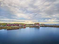 View of a hotel on the Hustadvika shoreline | |
 Coat of arms 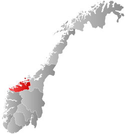 Møre og Romsdal within Norway | |
 Hustadvika within Møre og Romsdal | |
| Coordinates: 62.916796°N 7.227630°E | |
| Country | Norway |
| County | Møre og Romsdal |
| District | Nordmøre |
| Established | 1 Jan 2020 |
| Administrative centre | Elnesvågen |
| Government | |
| • Mayor (2020) | Tove Henøen (Sp) |
| Area | |
| • Total | 521.90 km2 (201.51 sq mi) |
| • Land | 507.69 km2 (196.02 sq mi) |
| • Water | 14.21 km2 (5.49 sq mi) 2.7% |
| Area rank | 203 in Norway |
| Population (2020) | |
| • Total | 13,279 |
| • Rank | 90 in Norway |
| • Density | 26.2/km2 (68/sq mi) |
| • Change (10 years) | 4.4% |
| Time zone | UTC+01:00 (CET) |
| • Summer (DST) | UTC+02:00 (CEST) |
| ISO 3166 code | NO-1579 |
| Official language form | Neutral[1] |
| Website | hustadvika |
The 522-square-kilometre (202 sq mi) municipality is the 203rd largest by area out of the 356 municipalities in Norway. Hustadvika is the 90th most populous municipality in Norway with a population of 13,279. The municipality's population density is 26.2 inhabitants per square kilometre (68/sq mi) and its population has increased by 4.4% over the previous 10-year period.[2][3]
General information
On 1 January 2020, the neighboring municipalities of Eide and Fræna were merged to form the new municipality of Hustadvika.[4][5]
Name
The municipality is named after the 19-kilometre (12 mi) long Hustadvika coastline, located in the northern part of the municipality. It is reminiscent of the name for the former municipality, Hustad, which existed from 1918 until its dissolution in 1964.
Coat of arms
The coat of arms was approved in 2019. They were designed by Madelen Behrendt and Øystein Hauge. They are blue with two white interlocking designs representing a fish and a plow. These were chosen to symbolize the two main industries of the municipality: fishing and agriculture.[6]
Churches
The Church of Norway has five parishes (sokn) within the municipality of Hustadvika. It is part of the Molde domprosti (arch-deanery) in the Diocese of Møre.
| Parish (sokn) | Church name | Location of the church | Year built |
|---|---|---|---|
| Bud | Bud Church | Bud | 1717 |
| Eide | Eide Church | Eide | 1871 |
| Gaustad Chapel | Gaustad, near Vevang | 2001 | |
| Hustad | Hustad Church | Hustad | 1874 |
| Myrbostad | Myrbostad Church | Elnesvågen | 1880 |
| Vågøy | Vågøy Church | Vågøya | 1904 |
Geography
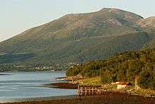
The municipality of Hustadvika sits on the northwestern end of the Romsdal Peninsula along the Hustadvika shoreline, just west of the island of Averøya. The Norwegian Sea lies to the north, the Harøyfjorden, Julsundet strait, and Aukra Municipality lie to the west, Molde Municipality and Gjemnes Municipality lie to the south, and Averøy Municipality and the Kornstadfjorden lie to the east.
The Frænfjorden cuts into the middle of the municipality. The coastal areas are low and marshy while the interior of the municipality is mountainous. Two of the more notable mountains are Jendemsfjellet and Heiane. The Bjørnsund islands lie off the northwestern coast. They are now uninhabited, but the Bjørnsund Lighthouse is still in operation. Kvitholmen Lighthouse lies just off the northern coast of the municipality, in an area with hundreds of small islands and skerries.
Government
All municipalities in Norway, including Hustadvika, are responsible for primary education (through 10th grade), outpatient health services, senior citizen services, unemployment and other social services, zoning, economic development, and municipal roads. The municipality is governed by a municipal council of elected representatives, which in turn elects a mayor.[7] The municipality falls under the Romsdal District Court and the Frostating Court of Appeal.
Municipal council
The municipal council (Kommunestyre) of Hustadvika is made up of 37 representatives that are elected to four year terms. The party breakdown of the council is as follows:
| Party Name (in Norwegian) | Number of representatives | |
|---|---|---|
| Labour Party (Arbeiderpartiet) | 7 | |
| Progress Party (Fremskrittspartiet) | 4 | |
| Green Party (Miljøpartiet De Grønne) | 1 | |
| Conservative Party (Høyre) | 5 | |
| Christian Democratic Party (Kristelig Folkeparti) | 2 | |
| Centre Party (Senterpartiet) | 16 | |
| Socialist Left Party (Sosialistisk Venstreparti) | 1 | |
| Liberal Party (Venstre) | 1 | |
| Total number of members: | 37 | |
References
- "Forskrift om målvedtak i kommunar og fylkeskommunar" (in Norwegian). Lovdata.no.
- Statistisk sentralbyrå (2020). "Table: 06913: Population 1 January and population changes during the calendar year (M)" (in Norwegian).
- Statistisk sentralbyrå (2020). "09280: Area of land and fresh water (km²) (M)" (in Norwegian).
- "Hustadvika kommune endelig vedtatt!" (in Norwegian). Fræna kommune. Archived from the original on 2017-10-10. Retrieved 2017-10-09.
- "Nye Eide og Fræna kommune" (in Norwegian). Archived from the original on 2017-10-10. Retrieved 2017-10-09.
- "En stor takk til designerne av det nye kommunevåpenet og til arkitektene bak sangen "I kjem frå Hustadvika"" (in Norwegian). Hustadvika kommune. Retrieved 2019-05-31.
- Hansen, Tore, ed. (2016-05-12). "kommunestyre". Store norske leksikon (in Norwegian). Kunnskapsforlaget. Retrieved 2019-03-06.
- "Tall for Norge: Kommunestyrevalg 2019 - Møre og Romsdal" (in Norwegian). Statistics Norway. Retrieved 2019-10-19.
Møre og Romsdal county, Norway | |||||
|---|---|---|---|---|---|
 |
|  | |||