Žarnovica
Žarnovica (German: Scharnowitz; Hungarian: Zsarnóca) is a town and municipality in the Žarnovica District, Banská Bystrica Region in Slovakia. The town is situated in the Hron river valley. It has a population of around 6,000 people.
Žarnovica | |
|---|---|
Town | |
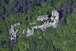 Ruins of castle Revište in municipal district Revištské Podzámčie | |
 Coat of arms | |
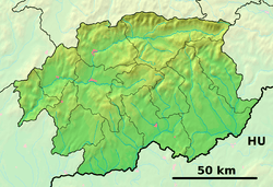 Žarnovica Location of Žarnovica in the Banská Bystrica Region  Žarnovica Žarnovica (Slovakia) | |
| Coordinates: 48°28′48″N 18°43′05″E | |
| Country | Slovakia |
| Region | Banská Bystrica |
| District | Žarnovica |
| First mentioned | 1332 |
| Government | |
| • Mayor | Kamil Danko |
| Area | |
| • Total | 30.399 km2 (11.737 sq mi) |
| Elevation | 230 m (750 ft) |
| Population (2018-12-31[1]) | |
| • Total | 6,180 |
| • Density | 200/km2 (530/sq mi) |
| Time zone | UTC+1 (CET) |
| • Summer (DST) | UTC+2 (CEST) |
| Postal code | 966 81 |
| Area code(s) | +421-45 |
| Car plate | ZC |
| Website | www.zarnovica.sk |
History
The first written mention about Žarnovica is dated to 1332.
Geography
Žarnovica lies at an altitude of 230 metres (755 ft) above sea level and covers an area of 30.4 square kilometres (11.7 sq mi).[2] It is located in the Žiar Basin in central Slovakia, on the Hron River, between Vtáčnik and Štiavnické vrchy mountain ranges.
Demographics
According to the 2001 census, the town had 6,596 inhabitants. 95.59% of inhabitants were Slovaks, 1.61% Roma and 0.73% Czechs. The religious make-up was 78.73% Roman Catholics, 15.25% people with no religious affiliation and 1.32% Lutherans.[2]
References
- "Population and migration". Statistical Office of the Slovak Republic. Retrieved 2019-04-16.
- "Municipal Statistics". Statistical Office of the Slovak Republic. Archived from the original on 2008-01-11. Retrieved 2008-01-26.