Hansborough, South Australia
Hansborough is a locality along the former Morgan railway line adjacent to the Thiele Highway, in South Australia's Mid North region. It is situated 9 kilometres south-west of Eudunda and 18 kilometres north-east of Kapunda. The Light River runs through the locality.
| Hansborough South Australia | |||||||||||||||
|---|---|---|---|---|---|---|---|---|---|---|---|---|---|---|---|
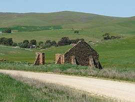 Ruins located at Hansborough | |||||||||||||||
 Hansborough | |||||||||||||||
| Coordinates | 34°15′09″S 139°00′47″E[1] | ||||||||||||||
| Population | 42 (2016 census)[2] | ||||||||||||||
| Established | 1865 (town) 16 March 2000 (locality)[1][3] | ||||||||||||||
| Abolished | 13 August 1936 (town)[4] | ||||||||||||||
| Postcode(s) | 5374 | ||||||||||||||
| Elevation | 333 m (1,093 ft) | ||||||||||||||
| Location |
| ||||||||||||||
| LGA(s) | |||||||||||||||
| State electorate(s) | Stuart | ||||||||||||||
| Federal Division(s) | |||||||||||||||
| |||||||||||||||
| |||||||||||||||
| Footnotes | Adjoining localities[1] | ||||||||||||||
A town was surveyed in July 1865 and named after Frederick Hansborough Dutton (1812-1890), an early pastoralist and an overlander, who founded Anlaby Station, near Kapunda. It was declared as ceasing to exist on 13 August 1936.[6][1] Boundaries were created for the part of the locality within the Light Regional Council on 16 March 2000 and for the part within the Regional Council of Goyder which includes the ceased Government Town of Hansborough on 24 August 2000.[1][3]
The Hundred of Neales School, later Freshwater Creek School, opened in 1927 in a former manager's residence on the Kingscourt property and closed in 1940.[7]
The 2016 Australian census which was conducted in August 2016 reports that Hansborough had a population of 42 people.[2]
See also
References
| Wikimedia Commons has media related to Hansborough, South Australia. |
- "Search results for 'Hansborough, LOCB' with the following datasets selected - 'Suburbs and Localities', "Counties', 'Government Towns', 'Local Government Areas', 'SA Government Regions', 'Gazetteer' and 'Roads'". Location SA Map Viewer. South Australian Government. Retrieved 10 May 2018.
- Australian Bureau of Statistics (27 June 2017). "State Suburb of Hansborough". 2016 Census QuickStats. Retrieved 5 March 2018.

- "GEOGRAPHICAL NAMES ACT 1991, Notice to Assign Names and Boundaries to Places (within the District Council of Kapunda and Light )" (PDF). The South Australian Government Gazette. South Australian Government. 5 December 1940. p. 1433. Retrieved 6 March 2018.
- "TOWN OF HANSBOROUGH TO CEASE TO EXIST" (PDF). The South Australian Government Gazette. South Australian Government. 13 August 1936. pp. 249–250. Retrieved 10 May 2018.
- "Monthly climate statistics: Summary statistics EUDUNDA (nearest weather station)]]". Commonwealth of Australia , Bureau of Meteorology. Retrieved 5 March 2018.
- "The Manning Index of South Australian History".
- Dreckow, Betty (1986). Hills, Valley and Plains: History of the Eudunda District. p. 272.