Marananga, South Australia
Marananga is a locality in South Australia. It was known as Gnadenfrei before 1918 when names of "enemy origin" were changed to sound less German.
| Marananga South Australia | |||||||||||||||
|---|---|---|---|---|---|---|---|---|---|---|---|---|---|---|---|
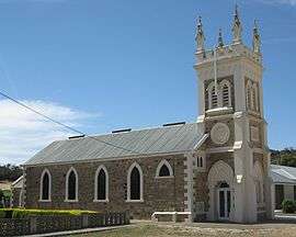 St. Michael's Gnadenfrei Lutheran Church in Marananga | |||||||||||||||
 Marananga | |||||||||||||||
| Coordinates | 34°29′13″S 138°56′19″E[1] | ||||||||||||||
| Population | 104 (2016 census)[2] | ||||||||||||||
| LGA(s) | Light Regional Council | ||||||||||||||
| State electorate(s) | Schubert | ||||||||||||||
| Federal Division(s) | Barker | ||||||||||||||
| |||||||||||||||
The Gnadenfrei Lutheran Church was established, then a German school was established in 1879. The school's name was changed to Marananga in 1918,[3] which is now also the name of the locality. Gnadenfrei means 'grace' and 'freedom'.[4] Marananga means "My hands" in the Aboriginal language of the Overland Corner tribe.[5]
References
| Wikimedia Commons has media related to Marananga, South Australia. |
- "Search results for 'Marananga, LOCB' with the following datasets selected - 'Suburbs and localities', 'Counties', 'Hundreds', 'Local Government Areas', 'SA Government Regions' and 'Gazetteer'". Location SA Map Viewer. South Australian Government. Retrieved 21 January 2020.
- Australian Bureau of Statistics (27 June 2017). "Marananga (State Suburb)". 2016 Census QuickStats.

- "EDUCATION NEWS". The Express and Telegraph. Adelaide, SA: National Library of Australia. 12 July 1918. p. 1 Edition: 5 O'CLOCK EDITION. Retrieved 15 February 2016.
- "Placename Details: Gnadenfrei (LOCU)". Property Location Browser. 11 December 2006. SA0026767. Archived from the original on 12 October 2016. Retrieved 15 February 2016.
- "Placename Details: Marananga (LOCB)". Property Location Browser. 11 December 2006. SA0042875. Archived from the original on 12 October 2016. Retrieved 15 February 2016.
This article is issued from Wikipedia. The text is licensed under Creative Commons - Attribution - Sharealike. Additional terms may apply for the media files.