Handforth
Handforth is a suburban town between Wilmslow, Heald Green and Styal in Cheshire, England.[2] The population of the civil parish as of the 2011 census was 6,266.[3] In the 1960s and 1970s, two overspill housing estates, Spath Lane in Handforth[4] and Colshaw Farm nearby in Wilmslow, were built to re-house people from inner city Manchester.[5]
| Handforth | |
|---|---|
 The Paddock (Handforth Precinct) | |
 Handforth Location within Cheshire | |
| Population | 6,266 (2011) |
| OS grid reference | SJ8583 |
| Civil parish |
|
| Unitary authority | |
| Ceremonial county | |
| Region | |
| Country | England |
| Sovereign state | United Kingdom |
| Post town | Wilmslow |
| Postcode district | SK9 |
| Dialling code | 01625 |
| Police | Cheshire |
| Fire | Cheshire |
| Ambulance | North West |
| UK Parliament | |
History
Handforth, township and hamlet with ry. sta., Cheadle par., E. Cheshire, 5 miles SW. of Stockport, 1311 ac., pop. 736; P.O., T.O.
Handforth's original name was Handforth cum-Bosden, and for many years it was in the parish of Cheadle. The name "Handforth" is believed to originate from the Saxon Hanna's Ford, when there was a crossing on the River Dean. The first mention of Handforth is in a charter dated between 1233 and 1236. Handforth is not mentioned in the Domesday Book of 1086 but, at that time, it may have been recorded as a component part of the parish of Cheadle. One of the earliest references to Handforth occurs in a deed of transfer (copy held by the John Rylands Library) between Lord Edmund Phitoun and Henry de Honeford and dated 1291. The deed relates to the site of a water mill and “assigns a whole half of the water of Honeford between the two highways of which a certain way comes from Wilmyslawe and the other way which comes from Macclisfeld and extends itself beyond said water towards Bolleschawehefd.”
During the Crusades, Handforth acquired its own Coat of Arms, which displays the Honford Star. The Honford Star originated from Henry de Honford who, while fighting in the Crusades, painted a silver star on his black shield after seeing a star fall from the sky during a night attack on the Saracens.[7] The town was referred to as Honford in John Speede's map of the area in 1611,[8] after the local feudal family known as the de Honford's.
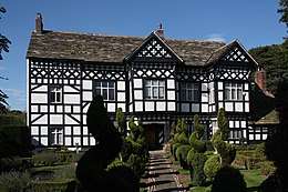
The oldest building in Handforth is Handforth Hall, a typically Tudor-styled black and white timber building built by Sir Urian Brereton in 1562. It was originally named Honford Hall after the de Honford's. Sir Urian was escheator of Cheshire, one of the privy grooms to King Henry and knighted in 1544 at Leith during an attack on Edinburgh. Sir Urian Brereton died at Handforth Hall on 19 March 1577 and is thought to be buried in a chapel at St Mary's Church, Cheadle. In the south chapel are three recumbent effigies. Two are in alabaster and are thought to represent members of the Hondford (or Handford) family, Sir John, who died in 1461 and his son, also named John. The third is in sandstone and represents Sir Thomas Brereton who died in 1673.[9] The most famous resident of Handforth is Sir Urian's great grandson, the Parliamentary General, Sir William Bereton, who fought in the Civil War.[10]
During the First World War an Internment camp was set up in Handforth for both civilian and military prisoners. The camp was converted from a disused print works built in 1910. The site was requisitioned by the War Office in 1914 and designed to hold no more than 3,000 men. Handforth camp was opened on 6 November 1914 with the arrival of 500 prisoners. From May 1915 following the aftermath of the Anti-German riots which swept a number of cities, and the decision to intern ‘enemy aliens’ the civilian population in the camp increased. A number of men were sent to Handforth from Liverpool. Handforth was inspected by an attaché to the American Embassy in London on 1 April 1916. At this time there were 2,713 prisoners at the camp. At the height of operations the internee population was greater than that of the village of Handforth itself. Later on when German soldiers captured from the front line started to arrive, the local population started to take a greater interest and watched the new arrivals, with crowds gathering at the nearby railway station. The Manchester Evening News reported on Wednesday 17 March 1915: "Great excitement prevailed at Handforth and Wilmslow today when it became generally known that about 600 German prisoners taken during heavy fighting in the North of France were expected to arrive for internment at the concentration camp."[11][12][13][14]
During the Second World War Handforth, along with Cheadle Hulme, was home to large parts of RAF Handforth. This was a maintenance unit, classed as a universal stores depot, and had the official Royal Air Force name RAF Handforth No 61 M.U. (Maintenance unit). The depot opened in 1939, closed in 1959 and covered large areas of land in both Handforth and neighbouring Cheadle Hulme.

The depot stored and dispatched every item that the RAF used in wartime, from knives and forks to aircraft engines. The site was served by a large, internal railway system which left the Manchester to Crewe mainline near Handforth railway station. The site of the exchange sidings and junction is at the rear of the Pets At Home offices on Epsom Avenue. The depot had its own shunting locomotives, which were stored in an engine shed that stood at the Wilmslow bound exit slip road for the Handforth Dean shopping centre.
The only surviving buildings of RAF Handforth are the government pay offices adjacent to the Total Fitness gym on Dairyhouse Lane. These buildings were the Headquarters of the depot and have survived in MoD use to this day.
In January 2017, government plans were announced to build a garden village on the eastern margin of Handforth village, to include 2,000 houses with facilities including a nursery and care home.[15]
Administrative history
Handforth-cum-Bosden was part of the Stockport Registration District between 1837 and 1877, until it was divided onto the separate parishes of Handforth and Bosden. Handforth continued to be part of the Stockport Registration District from 1877 to 1936 when it was then incorporated into the parishes of Wilmslow and Cheadle and Gatley. The parish of Bosden was abolished in 1900 and incorporated into the parish of Hazel Grove and Bramhall.[16]
Handforth along with other towns, such as Whitworth, Poynton and Alderley Edge, successfully objected to being part of the metropolitan county of Greater Manchester when it was formed in 1974, as a result of plans laid out in the Local Government Act 1972.[17] From 1974 until the changes in local government which occurred in 2009, Handforth was administered by both the Macclesfield Borough Council and also the Cheshire County Council. On 1 April 2009, it became part of the Cheshire East unitary authority.[18]
Geography
Handforth borders Heald Green to the north and Wilmslow to the south, between the Cheshire Plain and the Pennines.[19] The area lies near the River Dean, a tributary of the River Bollin that flows north–west and eventually joins the River Mersey near Lymm. The local geology is mostly glacial clay, as well as glacial sands and gravel.[20][21]
The majority of buildings in the area are houses which date from the 20th or 21st centuries. However, there are a few buildings in the area that are earlier than that and date back to before the 20th century and as far as the 16th century (such as Handforth Hall).
Neighbouring districts and places. | |
|---|---|
Climate
Handforth experiences a temperate maritime climate, like much of the British Isles, with relatively cool summers and mild winters.
| Handforth | ||||||||||||||||||||||||||||||||||||||||||||||||||||||||||||
|---|---|---|---|---|---|---|---|---|---|---|---|---|---|---|---|---|---|---|---|---|---|---|---|---|---|---|---|---|---|---|---|---|---|---|---|---|---|---|---|---|---|---|---|---|---|---|---|---|---|---|---|---|---|---|---|---|---|---|---|---|
| Climate chart (explanation) | ||||||||||||||||||||||||||||||||||||||||||||||||||||||||||||
| ||||||||||||||||||||||||||||||||||||||||||||||||||||||||||||
| ||||||||||||||||||||||||||||||||||||||||||||||||||||||||||||
| Climate data for Handforth | |||||||||||||
|---|---|---|---|---|---|---|---|---|---|---|---|---|---|
| Month | Jan | Feb | Mar | Apr | May | Jun | Jul | Aug | Sep | Oct | Nov | Dec | Year |
| Record high °C (°F) | 15 (59) |
17 (63) |
19 (66) |
25 (77) |
27 (81) |
29 (84) |
32 (90) |
34 (93) |
27 (81) |
23 (73) |
18 (64) |
15 (59) |
34 (93) |
| Average high °C (°F) | 8 (46) |
8 (46) |
10 (50) |
13 (55) |
16 (61) |
19 (66) |
21 (70) |
21 (70) |
18 (64) |
14 (57) |
10 (50) |
7 (45) |
14 (57) |
| Average low °C (°F) | −2 (28) |
2 (36) |
3 (37) |
5 (41) |
8 (46) |
10 (50) |
12 (54) |
12 (54) |
10 (50) |
7 (45) |
4 (39) |
2 (36) |
6 (43) |
| Record low °C (°F) | −8 (18) |
−8 (18) |
−8 (18) |
−4 (25) |
−2 (28) |
1 (34) |
5 (41) |
2 (36) |
−1 (30) |
−4 (25) |
−8 (18) |
−12 (10) |
−12 (10) |
| Average precipitation mm (inches) | 69 (2.7) |
70 (2.8) |
50 (2.0) |
63 (2.5) |
51 (2.0) |
58 (2.3) |
54 (2.1) |
69 (2.7) |
63 (2.5) |
88 (3.5) |
82 (3.2) |
78 (3.1) |
795 (31.3) |
| Source: My Weather 2[22] | |||||||||||||
Physical geography
The eastern half of Cheshire, in which Handforth is located, is Upper Triassic Mercia Mudstone laid down with large salt deposits which were mined for hundreds of years around Northwich. Separating this area from Lower Triassic Sherwood Sandstone to the west is a prominent sandstone ridge known as the Mid Cheshire Ridge. A 55-kilometre (34 mi) footpath,[23] the Sandstone Trail, follows this ridge from Frodsham to Whitchurch passing Delamere Forest, Beeston Castle and earlier Iron Age forts.[24]
The highest point in Cheshire is Shining Tor on the Derbyshire/Cheshire border between Macclesfield and Buxton, at 559 metres (1,834 ft) above sea level. Before county boundary alterations in 1974, the county top was Black Hill (582 m (1,909 ft)) near Crowden in the far east of the historic county on the border with the West Riding of Yorkshire. Black Hill is now the highest point in West Yorkshire.
Governance
Handforth is situated in Cheshire East, a unitary authority area with borough status in the county of Cheshire.[18] Handforth falls within the constituency of Tatton, a strongly Conservative constituency represented by Esther McVey.[25] It is the third most affluent constituency in the UK outside of Kensington and Cities of London and Westminster.[25] The area is also represented in the European Parliament by being part of the North West England constituency.[26]
Demography
Population
The historic population of Handforth was 650 in 1851, and 911 in 1901.[27] According to the United Kingdom Census 2011, the Handforth Ward has a population of 9,139 people.[28] This is an increase from the data in the 2001 Census, when the Handforth Ward had a population of 8,014 people. The gender composition of Handforth is made up of 4,640 females (50.8%) and 4,499 males (49.2%).[29][30][31]
| Historical populations | ||||||||||||||||||||||||||||||||||||||||||||||||||||||||||||||||
|---|---|---|---|---|---|---|---|---|---|---|---|---|---|---|---|---|---|---|---|---|---|---|---|---|---|---|---|---|---|---|---|---|---|---|---|---|---|---|---|---|---|---|---|---|---|---|---|---|---|---|---|---|---|---|---|---|---|---|---|---|---|---|---|---|
|
| |||||||||||||||||||||||||||||||||||||||||||||||||||||||||||||||
| Source: Cheshire County Council: Township Pack No 48.[32] [33] | ||||||||||||||||||||||||||||||||||||||||||||||||||||||||||||||||
| Handforth Compared | |||
|---|---|---|---|
| 2011 UK Census | Handforth | Cheshire East | England |
| Total population | 9,138 | 370,127 | 53,012,456 |
| White | 91.6% | 96.7% | 85.5% |
| Asian | 4.7% | 1.6% | 7.7% |
| Black | 0.8% | 0.4% | 3.4% |
Ethnicity
According to the 2011 Census, ethnic white groups (British, Irish, other) account for 8,375 (91.6%) of the population, against 96.8% in the previous 2001 census, with 8.4% (764 people) being in ethnic groups other than white.
Of the 8.4% (764 people) in non-white ethnic groups:
Religion
A breakdown of religious groups and denominations (2011 vs 2001):
- Christian - 63.5% (5,805 people) against 79.2% (6345 people)
- No religion - 24.5% (2,244 people) against 12.8% (1,026 people)
- Muslim - 2.7% (250 people) against 1% (82 people)
- Hindu - 0.9% (78 people) against 0.4% (31 people)
- Religion not stated - 6.8% (621 people) against 5.9% (473 people)
- Sikh -0.5% (43 people) against 0.1% (8 people)
- Jewish - 0.4% (36 people) against 0.3% (27 people)
- Other religions - 0.4% (34 people) against 0.1% (10 people)
- Buddhist - 0.3% (28 people) against 0.2% (12 people)[35]
Places of Worship
There are three churches in Handforth:
Methodist: St. Mary's Methodist Church was built in 1872, however Methodism was present in the Handforth and Wilmslow area long before this. It is recorded that John Wesley preached at nearby Finney Green on 1 September 1748.[36]
Roman Catholic: St. Benedict's Roman Catholic Church, part of the Diocese of Shrewsbury.[37] The Church was officially opened by the Bishop of Shrewsbury on 29 November 1968. It is perhaps particularly important to its congregation that the ground on which they tread when entering the Church was once trodden on by Ambrose Barlow on the way to his mother's birthplace at Handforth Hall, and that the youthful scholars of the nearby St Benedict's school are playing in a playground which was once the 'garden or pleasureground' mentioned by Richard Brooke.[38]
Anglican: St. Chad's Church of England, which is part of the Diocese of Chester, is the Anglican Church based in Handforth. During the 19th century a Chapel of ease was built in Handforth, which was part of the Parish of Cheadle. It was consecrated in 1837 as a chapel to St Mary's Church, Cheadle, becoming the parish church for Handforth and part of Cheadle in 1877. Due to growth of the Handforth population in the late 19th century, the Church went through extensive redevelopment and expansion and the new St Chad's Church was consecrated by Francis Jayne, Bishop of Chester on St Chad's Day, 2 March 1899.[27][39][40][41]
Transport
Handforth railway station is on a double-track electrified line that runs from Manchester Piccadilly to Crewe via Levenshulme, Cheadle Hulme, Stockport and Wilmslow.[42] The A34 bypass is situated to the east [43] and the main thoroughfare is Wilmslow Road (B5358).[44] Manchester Airport lies just 3.5miles (6 km) to the north west, but Handforth lies away from the approach and departure routes and therefore suffers only slightly from aircraft noise.[45]
Economy
Handforth Dean is a retail park that houses shops such as Tesco, Marks & Spencer Outfit and Boots the Chemist, and is situated by the A34 bypass.[46] Pets at Home has its headquarters in Handforth.[47]
Public services
Health
Handforth Health Centre, purpose built in 1975, was purchased from the Health Authority by the GPs in 1992 and completely refurbished.[48]
Schools
Handforth is served by three primary schools: Wilmslow Grange, Dean Oaks Primary and St. Benedict's RC Primary.
Police
Handforth is served by Cheshire Constabulary, with the closest branch being based in Wilmslow.[49]
Fire
Cheshire Fire and Rescue Service is the fire service that caters for Handforth, with the nearest fire station being located in Wilmslow.[50]
Facilities
Parks
Meriton Road Park, opened in 1935, covers an area of 3.4 hectares (9 acres)[51] and is situated to the rear of the Paddock Shopping Centre. Until the mid-1980s the park was the site for the Handforth Gala. Current attractions in the park include a multi-sport court, tennis courts and a miniature railway which is operated by Handforth Model Engineering Society.
Stanley Hall Park is situated between the Spath Lane Estate and the railway line from Handforth to Cheadle Hulme. The park was donated by Manchester City Council in the early 1960s. The park is owned and maintained by Cheshire East Councils environmental partner Ansa and has an active friends of the park group. Facilities include the Swingtime play areas and muga both donated by Spath Lane Residents Association and a 52-seat all-inclusive picnic area with space for 15 wheelchairs or buggies and a concrete skatepark installed by the Friends of Stanley Hall Park in 2015/16.
References
- "Home Page". www.handforth.org.uk.
- "HANDFORTH : latitude, longitude, map and postcode / zip code of Handforth SK9 in United Kingdom". Zip-code.en.mapawi.com. Retrieved 11 August 2014.
- "Civil Parish population 2011". Neighbourhood Statistics. Office for National Statistics. Retrieved 13 March 2016.
- Google Maps: Handforth (Retrieved 29 November 2014)
- Google Maps: Colshaw Farm (Retrieved 29 November 2014)
- "History of Handforth, in Macclesfield and Cheshire | Map and description". Visionofbritain.org.uk. 1887. Retrieved 29 November 2014.
- Graham Rollason, Handforth Archived 10 November 2011 at the Wayback Machine (Retrieved 4 December 2014)
- Map of Cheshire, by John Speed, Published By Basset & Chiswell, 1676 Archived 30 June 2012 at the Wayback Machine (Retrieved 29 November 2014)
- Richards, Raymond (1947), Old Cheshire Churches, London: Batsford, pp. 91–93
- "Cheshire Magazine". Cheshire Magazine. Retrieved 11 August 2014.
- "Handforth Internment Camp". merseyside-at-war.org.
- ‘Handforth, Cheshire East: German Takeover of a Sleepy Village’, BBC World War One at Home http://www.bbc.co.uk/programmes/p023084q
- ‘Handforth Concentration Prison’, Diverse Narratives of WWI, http://diversenarratives.com/2015/02/05/handforth-concentration-prison/
- ‘Prisoners of War and Internees (Great Britain)’, International Encyclopaedia of the First World War, http://encyclopedia.1914-1918-online.net/article/prisoners_of_war_and_internees_great_britain
- Jessica Elgot (2 January 2016). "Fourteen garden villages to be built in England totalling 48,000 homes". The Guardian. Retrieved 2 January 2016.
- "Stockport Registration District". Ukbmd.org.uk. Retrieved 11 August 2014.
- Local Government Act 1972 (Retrieved 29 November 2014)
- Archived 27 July 2011 at the Wayback Machine
- Macchi, L. (1990). "A Field Guide to the Continental Permo-Triassic Rocks of Cumbria and Northwest Cheshire". Liverpool Geological Society, Liverpool: 88 pages.
- Taylor, B.; Price R., and Trotter F. (1963). "The geology of the Country around Stockport and Knutsford". Memoir of the Geological Survey GB: pp 20–22.
- British Geological Survey 1:50K map series sheets 96-98, 108-110, 122,123 and accompanying memoirs
- "December Climate History for Handforth | Local | Cheshire, United Kingdom". Myweather2.com. Retrieved 11 August 2014.
- Archived 2 May 2010 at the Wayback Machine
- "Walking Cheshire's Sandstone Trail". Archived from the original on 22 July 2011.
- "George Osborne | MP for Tatton". Georgeosborne4tatton.com. Retrieved 11 August 2014.
- "European Election 2009, North West Results". BBC News. 19 April 2009.
- "Cheshire Towns & Parishes : Handforth". Ukbmd.org.uk. Retrieved 11 August 2014.
- Office for National Statistics (Retrieved 29 November 2014)
- Office for National Statistics (Retrieved 30 November 2014)
- Office for National Statistics, Neighbourhood Statistics (Retrieved 30 November 2014)
- Office for National Statistics, Neighbourhood Statistics: Lead View Table (Retrieved 30 November 2014)
- Cheshire County Council, Archives and Local Studies, Township Pack, No 48.{{
- http://www.handforthnplan.org/resources/handforthPPFA.docx
- Office For National Statistics, Neighbourhood Statistics - Ethnic Group, 2011 (Retrieved 2014-08-11)
- Office For National Statistics, Neighbourhood Statistics - Religion, 2001 (UV15) (Retrieved 4 December 2014)
- https://web.archive.org/web/20120425152515/http://www.bramhallmethodists.org.uk/circuit/index.php?option=com_content&view=article&id=52&Itemid=70. Archived from the original on 25 April 2012. Retrieved 19 February 2016. Missing or empty
|title=(help) - "Useful Links". St. Benedict's Catholic Primary School. Retrieved 30 November 2014.
- Heusel, F.E. (1982) Handforth Through The Ages, Cheshire Libraries and Museums
- SRM © 2006. "St Chad's Parish Church, Handforth, Cheshire". Stchadshandforth.org.uk. Retrieved 11 August 2014.
- Church of England: Diocese of Chester (Retrieved 30 November 2013)
- RC Diocese of Shrewsbury (Retrieved 30 November 2013)
- Archived 10 March 2012 at the Wayback Machine
- AA Road Book of England and Wales, 4th edition (1953)
- B5358, Roader's Digest (Retrieved 30 November 2013)
- Manchester (Handforth) Hotel , Premier Inn Official website (Retrieved 30 November 2014)
- Handforth Dean: That bit of Handforth that's sort of in Wilmslow..., The Wilmslow Website (Retrieved 30 November 2013)
- Archived 17 July 2011 at the Wayback Machine
- Handforth Health Centre Official Website (Retrieved 30 November 2014)
- Cheshire Constabulary: Eastern BCU Archived 20 October 2011 at the Wayback Machine (Retrieved 30 November 2014)
- Cheshire Fire and Rescue Service (Retrieved 30 November 2014)
- Archived 22 February 2014 at the Wayback Machine
External links
| Wikimedia Commons has media related to Handforth. |
- Friends of Handforth Station
- Handforth Model Engineering Society
- Handforth Hall
- Saint Benedict's Roman Catholic Church
- Saint Chad's Parish Church of England
- Handforth
- Handforth on Google Maps
Cheshire Portal | |
| Unitary authorities | |
| Major settlements |
|
| Rivers | |
| Topics | |
| Authority control |
|
|---|