Bramhall
Bramhall is a suburb in the Metropolitan Borough of Stockport, England.[1][2][3] Historically in Cheshire, it had a population of 17,436 at the 2011 Census.[4][5][6] In 2008, Bramhall was named 'Britain's Friendliest Village' in the BBC's Changing UK report and in 2011 was named 'Cheshire's Culinary Capital' by Cheshire Life Magazine.[7][8]
| Bramhall | |
|---|---|
 Bramall Hall is a Tudor mansion and local landmark. | |
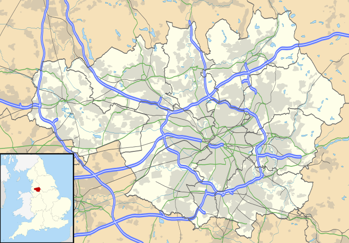 Bramhall Location within Greater Manchester | |
| Area | 15.93 km2 (6.15 sq mi) |
| Population | 17,436 (2011) |
| • Density | 1,095/km2 (2,840/sq mi) |
| OS grid reference | SJ890845 |
| Metropolitan borough | |
| Metropolitan county | |
| Region | |
| Country | England |
| Sovereign state | United Kingdom |
| Post town | STOCKPORT |
| Postcode district | SK7 |
| Dialling code | 0161 |
| Police | Greater Manchester |
| Fire | Greater Manchester |
| Ambulance | North West |
| UK Parliament | |
History
The manor of Bramall dates from the Anglo-Saxon period, when it was held as two separate estates by two Saxon freemen, Brun and Hacun.[9] In 1070, William the Conqueror subdued the north-west of England, and divided the land among his followers. The manor of "Bramale" was given to Hamon de Massey, who eventually became the first Baron of Dunham Massey.[10] The earliest reference to Bramall was recorded in the Domesday Book as "Bramale", a name derived from the Old English words brom meaning broom, both indigenous to the area, and halh meaning nook or secret place, probably by water. De Masci received the manor as wasteland, since it had been devastated by William the Conqueror's subdual. By the time of the Domesday survey, the land was recovering and cultivated again.[11]
In 1875, Bramhall was one of eight civil parishes of Cheshire to be included in the Stockport Rural rural sanitary district. The sanitary district became the Stockport Rural District in 1894. The parish was abolished in 1900 and its former area became part of the Hazel Grove and Bramhall civil parish and urban district. In 1974, the district was abolished, under the Local Government Act 1972, and its former area was transferred to Greater Manchester to be combined with that of other districts to form the Metropolitan Borough of Stockport.[12]
Governance
Bramhall is part of the parliamentary constituency of Cheadle. Mary Robinson, Conservative, has been the local MP since 2015.
Landmarks

Bramall Hall, situated in 26 hectares (64 acres) of parkland, is an example of a 14th-century Cheshire building. In 2016 an extensive programme of restoration work was completed by a dedicated team. The Ladybrook flows through the park towards Cheadle and Bramall Hall.
The war memorial commemorates the deaths of 89 men killed in the two world wars.[13]
Churches
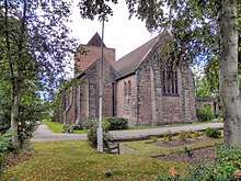
The Church of England parish church of St Michael and All Angels[14] in Robins Lane was consecrated in 1911 when Bramhall Parish was created, although the building was not completed until 1963. It replaced an earlier mission church opened in 1890.[15]
Other churches in Bramhall include the Methodist Church near the centre of the village, the United Reformed Church located on Bramhall Lane South, the Baptist Church located on Woodford Road, the Catholic Church of St. Vincent de Paul on Handley Road and Ford's Lane Evangelical Church.
Recreation
Bramhall has a cricket club and there are three lawn tennis clubs (LTC): Bramhall Queensgate LTC, to the north; Bramhall Lane LTC, close to the village; and Bramhall Park LTC, close to the park. There are also two golf clubs in Bramhall, each with 18-hole courses: Bramhall Golf Club and Bramall Park Golf Club. Stockport RUFC in Bramhall has been host to Headlander Festival. There is a recreation centre linked with Bramhall High School with indoor and outdoor facilities.
Transport
Bramhall railway station is on the main line from Manchester to London, via Macclesfield and Stoke-on-Trent. Local trains stop every hour Monday-Saturday on their way to/from Manchester Piccadilly and Stoke-on-Trent; there is a much reduced service on Sunday.
Buses link Bramhall to Manchester (42B), Stockport (378), Cheadle Hulme (42B,307/8), Woodford (42B), Parrs Wood (42B) and Hazel Grove (307/8).
Neighbouring districts and places. | ||||||||||
|---|---|---|---|---|---|---|---|---|---|---|
| ||||||||||
Amenities
Bramhall has a number of bars, restaurants, cafes, clothes shops, hairdressers, beauty salons, charity shops, churches and a library. Many of these are housed inside and around the village square,[16] although some shops along the main roads. There is also a recreation centre.
Housing
Bramhall's property market is dominated by detached and semi-detached properties with a small part being made up of terraced homes and flats.[17] Many of the region's footballers choose to live in the 'mansions of Alderley Edge, Prestbury, Bowdon, Bramhall and Hale'[18], highlighting Bramhall as a desirable suburban location.
Alongside numerous listed buildings,[19] the sixties and early seventies saw a growth in Bramhall's housing stock. New developments included the Parkside and New House Farm areas in the north of Bramhall and the Dairyground estate which features a co-operative, apartments and a care home. The Dairyground estate is served by Stagecoach Manchester[20] and is in close proximity to Bramhall railway station. Bramhall High School is situated in the Dairyground estate, which is part of the Bramhall North Ward.[21]
Little Australia
The area of Little Australia (so called as all the roads are named after towns in Australia) is bordered by the West Coast Main Line to the north, the Bramhall oil terminal to the east, Bramhall village centre to the west and Moorend Golf Club to the south. The longest road in Little Australia is Meadway, which starts in Bramhall shopping centre and runs through the heart of the estate for its entire length. Meadway has a number of shops, care homes and two large car parking facilities which are served by multiple CCTV cameras. There is also a recycling centre situated on the Meadway East car park. Lumb Lane park is located on the estate and consists of two football pitches, a small children's playground and a hard surface football/basketball court. Bramhall Village Hall is located on Lumb Lane. Queensgate Primary School is located on Albany Road. Little Australia is part of the Bramhall South Ward.
New House Farm
The New House Farm area is to the north of Bramhall and extends into Hazel Grove after crossing the Fred Perry Way. It is home to a McColl's newsagent and a pub, the Shady Oak. The main roads through New House Farm are Grange Road, which links to Bramhall Lane South, and Ringmore Road. New House Farm is served by the 374 bus route between Hazel Grove Station and Reddish. The New House Farm area contains a section of the Fred Perry Way joining the estate from Bridge Lane and exiting up into Woodsmoor. This area is part of the Bramhall North Ward.
Education
Bramhall has five primary schools: Ladybrook, Moss Hey, Nevill Road, Pownall Green and Queensgate. Bramhall High School is the local secondary school.
Notable people
Notable local residents have included:
- George Best – Former Manchester United football player [22]
- Peter Schmeichel – Former Manchester United and Manchester City football player [23]
- Yvette Fielding – Actress and Blue Peter presenter
- Peter Butterworth – Comedy actor and comedian
- Dame Wendy Hiller – Actress born in Bramhall [24]
- Sacha Dhawan – Actor born in Bramhall
- Martin Fry – Lead singer of the band ABC
- Mark Hadfield – Actor born in Bramhall
- Peter Barkworth – Actor
- Steve Bruce – Football manager and former Manchester United footballer, lived off Robins Lane
- Ole Gunnar Solskjær – Former Manchester United player and their current manager, lived in Bramhall whilst a player.
- Lauren Drummond – Actress, who attended Bramhall High School
- Phil Foden – Current Manchester City football player [25]
- Kasper Schmeichel – Current Leicester City and former Manchester City football player [26]
- Uwe Rosler – Former Manchester City football player [27]
- Keith Fielding – Former England and Great Britain international rugby player [28]
- Paul Ince – Former Manchester United football player [29]
External links
References
- Williams, Jennifer (3 December 2008). "Happy to be home in Bramhall". Stockport Express. M.E.N. Media.
- "Bramhall named friendliest spot". Manchester Evening News. 19 April 2010. Retrieved 11 March 2014.
- Stockport council (2005),"Bramhall Area Public Health Report".
- "Village population 2011". Retrieved 8 January 2016.
- Bramhall South and Bramhall North Wards"Ward mid-year population estimates for England and Wales (experimental)". Office for National Statistics. Mid-2007 Quinary Estimates for 2009 wards (experimental).
- "history and facts". I Love Bramhall. Retrieved 29 January 2020.
- News, Manchester Evening (19 April 2010). "Bramhall named friendliest spot". men. Retrieved 29 January 2020.
- "Is Bramhall Cheshire's culinary capital?". Cheshire Life Magazine. Retrieved 29 January 2020.
- Bramhill info, Retrieved 26 January 2015
- "Bramhall Park (2005)". Stockport Metropolitan Borough Council. Retrieved 11 March 2014.
- Dean, p14
- http://www.manchesteronline.co.uk/ewm/maps/districtstext.html
- "The Men of the Bramhall War Memorial" (PDF). Archived from the original (PDF) on 13 November 2013. Retrieved 13 November 2013.
- "Bramhall Parish Church – St Michaels".
- "BRAMHALL, ST MICHAEL AND ALL ANGELS". The National Archives. Retrieved 13 November 2013.
- http://www.bramhallcentre.co.uk/
- "Why you should move to Bramhall". Cheshire. Retrieved 29 January 2020.
- Brennan, Stuart (17 January 2018). "Why have so many Man City players moved to the city centre?". men. Retrieved 29 January 2020.
- "Listed Buildings in Bramhall South and Woodford Ward, Stockport". britishlistedbuildings.co.uk. Retrieved 29 January 2020.
- "Archived copy". Archived from the original on 31 March 2009. Retrieved 11 February 2010.CS1 maint: archived copy as title (link)
- Skinner, Miles (29 November 2006). "Bramhall businesses forced to barricade themselves in". Stockport Express. M.E.N. Media.
- "Inside the late British football star George Best's house". House and Garden. Retrieved 29 January 2020.
- "The 11 footballers on the right are hot property. But do they live in one?". Independent. Retrieved 29 January 2020.
- "Dame Wendy Hiller | British actress". Encyclopedia Britannica. Retrieved 29 January 2020.
- "Manchester City starlet Phil Foden buys new £2m home". Mail Online. Retrieved 29 January 2020.
- "Schmeichel and Bruce are back in action". The Mirror. Retrieved 29 January 2020.
- "'Cancer did not change me. I still have the same hunger for my profession". Independent. Retrieved 29 January 2020.
- News, Manchester Evening (19 April 2010). "Bramhall named friendliest spot". men. Retrieved 29 January 2020.
- "AT HOME WITH PAUL INCE". The Independent. 30 September 1995. Retrieved 29 January 2020.