Bulkeley
Bulkeley (/ˈbʊkli/)[1] is a village and civil parish in Cheshire, England, on the A534 9 miles west of Nantwich. In 2001, it had a population just below 250.[2]
| Bulkeley | |
|---|---|
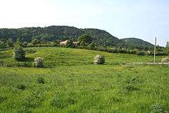 Pasture at Bulkeley, showing Bulkeley Hill | |
 Bulkeley Location within Cheshire | |
| Population | 239 (2011) |
| OS grid reference | SJ530545 |
| Civil parish |
|
| Unitary authority | |
| Ceremonial county | |
| Region | |
| Country | England |
| Sovereign state | United Kingdom |
| Post town | MALPAS |
| Postcode district | SY14 |
| Dialling code | 01829 |
| Police | Cheshire |
| Fire | Cheshire |
| Ambulance | North West |
| UK Parliament | |
The name was first recorded as Bulceleia in 1086, from Old English bulluc + leah, "pasture where bullocks graze".[3]
Governance
Bulkeley is administered jointly with Ridley by Bulkeley and Ridley Parish Council.[4] From 1974 the civil parish was served by Crewe and Nantwich Borough Council, which was succeeded on 1 April 2009 by the new unitary authority of Cheshire East.[5] Bulkeley falls in the parliamentary constituency of Eddisbury,[6] which has been represented by Edward Timpson since 2019,[7] after being represented by Stephen O'Brien (1999–2015) and Antoinette Sandbach (2015–19).
Geography and economy
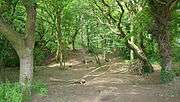
Bulkeley Hill (SJ525552) forms the southern end of the Peckforton Hills.[8] It is owned by the National Trust, and its wooded slopes include 12 acres (5 hectares) of semi-natural ancient woodland.[9] The hill has been designated a county site of biological importance for its woodland and grassland habitats.[10] A wider area covering the northern part of the civil parish has also been designated an Area of Special County Value.[11] Another unnamed elevation of around 135 metres is located south west of Bulkeley village at SJ525540, and an unnamed brook runs east–west along the valley between it and Bulkeley Hill.[8]
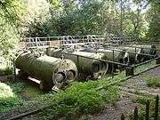
Two covered reservoirs are located on Bulkeley Hill (at SJ525550 and SJ528552), with a pumping station at the base (SJ529553); a disused inclined plane runs westwards from the pumping station.[12] Formerly owned by Staffordshire Potteries Water Board, the facility is now operated by Severn Trent Water. A small wooded area of access land containing two ponds is located at SJ532545, immediately east of Bulkeley village and north of the A534, and there are several other meres and ponds scattered across the farmland.[8]
The land use is predominantly agricultural, with cattle pasture, horse paddocks and some arable land.
Demography
According to the 2001 census the civil parish had a population of 240 in 106 households.[13] The population at the 2011 Census had reduced marginally to 239.[14] These figures represents an increase from the 1951 population; the historical population figures were 184 (1801), 197 (1851), 168 (1901) and 146 (1951).[2]
Places of worship
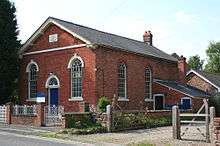
Bulkeley Methodist Church is a red-brick chapel in Bulkeley village. Dating from 1861, it was formerly the Jubilee Primitive Methodist Chapel and is listed at grade II.[15]
Other landmarks

Bulkeley Hall (SJ523537) is a three-storey mansion in brown brick which dates from the mid-18th century; it is grade II* listed.[16] Springfield Cottage (SJ528541) is a timber-framed cottage dating from the late 17th century.[17] A former corn mill stands on Mill Lane (SJ530549) to the north of Bulkeley village.[18]
Bulkeley Grange (SJ534541) is a grade-II-listed Victorian red-brick mansion in Jacobean style;[19] the house was rebuilt by railway builder, Thomas Brassey, in 1843.[20] A monument consisting of four inscribed sandstone pillars connected by iron straps was erected around an oak tree near The Grange in 1845, to commemorate Brassey's fortieth birthday. In 2007, it was moved to a location just to the east of Bulkeley village, adjacent to the A534 (SJ532544); the site has an interpretative sign.[20]

Transport
The A534 (Wrexham Road) between Nantwich and Wrexham runs east–west across the civil parish. Other through routes include Stone House Lane, which runs from the A534 to Peckforton. Mill Lane connects Stone House Lane with the A534 and Cholmondeley Lane runs south to Bulkelehay. The Sandstone Trail long-distance footpath runs over Bulkeley Hill.[21]
Education
Bulkeley civil parish falls within the catchment areas of Bickerton Holy Trinity CE Primary School in Bickerton and Bishop Heber High School in Malpas.[22][23]
See also
References
- G.M. Miller, BBC Pronouncing Dictionary of British Names (Oxford UP, 1971), p. 22.
- Genuki: Bulkeley (accessed 13 February 2008)
- A.D. Mills, Dictionary of English Place-Names (Oxford UP, 2nd ed., 1998), p. 61.
- Cheshire East Council: Clerks of Town Councils, Parish Councils and Parish Meetings 2009/2010 (downloaded from Archived 13 March 2010 at the Wayback Machine; 29 March 2010)
- Cheshire (Structural Changes) Order 2008 Archived 17 May 2009 at the Wayback Machine
- Cheshire East Council & Cheshire West and Chester Council: Interactive Mapping: Eddisbury Archived 3 October 2016 at the Wayback Machine (accessed 29 March 2010)
- Eddisbury Parliamentary constituency, BBC, retrieved 19 December 2019
- Ordnance Survey Explorer 257: Crewe & Nantwich; Whitchurch & Tattenhall
- The National Trust Handbook for Members and Visitors 2008, p.265
- Borough of Crewe & Nantwich: Nature Conservation Sites Archived 4 June 2008 at the Wayback Machine (accessed 14 February 2008)
- Cheshire County Council: Interactive Mapping: Areas of Special County Value: Beeston/Peckforton/Bolesworth/Bickerton Hills (accessed 28 May 2008)
- Cheshire County Council: Interactive Mapping (accessed 1 March 2008)
- Neighbourhood Statistics: Bulkeley CP (accessed 28 May 2008)
- "Civil Parish population 2011". Neighbourhood Statistics. Office for National Statistics. Retrieved 16 March 2016.
- Images of England: Bulkeley Methodist Church (accessed 13 February 2008)
- Images of England: Bulkeley Hall (accessed 13 February 2008)
- Images of England: Springfield Cottage (accessed 13 February 2008)
- Borough of Crewe & Nantwich: List of Locally Important Buildings Archived 4 June 2008 at the Wayback Machine (accessed 14 February 2008)
- Images of England: Bulkeley Grange (accessed 13 February 2008)
- Hastings I, Dixon M. The Thomas Brassey Tribute Stones Project. The Sandstone News, 9: 1–3 Archived 28 February 2008 at the Wayback Machine (accessed 26 May 2008)
- Cheshire County Council: Interactive Mapping: Bulkeley CP (accessed 28 May 2008)
- Cheshire County Council: Interactive Mapping: Bickerton Holy Trinity CE Primary School Archived 3 June 2008 at the Wayback Machine (accessed 25 May 2008)
- Cheshire County Council: Interactive Mapping: Bishop Heber High School Archived 3 June 2008 at the Wayback Machine (accessed 25 May 2008)
External links
| Wikimedia Commons has media related to Bulkeley. |
Cheshire Portal | |
| Unitary authorities | |
| Major settlements |
|
| Rivers | |
| Topics | |