Guanare
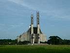
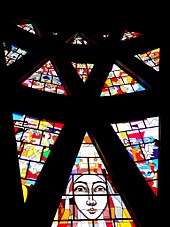
Guanare (Spanish pronunciation: [ɡwaˈnaɾe]) is the capital and most populated city of Portuguesa State, Venezuela. It is where la Virgen de Coromoto is said to have appeared to a Coromoto Indian.
Guanare | |
|---|---|
City | |
| Guanare | |
     | |
 Flag | |
.svg.png) Guanare | |
| Coordinates: 9°02′37″N 69°44′56″W | |
| Country | |
| State | |
| Founded | 3 November 1591 |
| Area | |
| • Total | 2,008 km2 (775 sq mi) |
| Elevation | 183 m (600 ft) |
| Population (2008) | |
| • Total | 235,201 |
| • Density | 100.63/km2 (260.6/sq mi) |
| • Demonym | Guanareño(a) |
| Time zone | UTC-4:30 (VST) |
| • Summer (DST) | UTC-4:30 (not observed) |
| Postal code | 3350 |
| Area code(s) | 0257 |
| Climate | Aw |
| Website | Alcaldía de Guanare (in Spanish) |
| The area and population figures are for the municipality | |
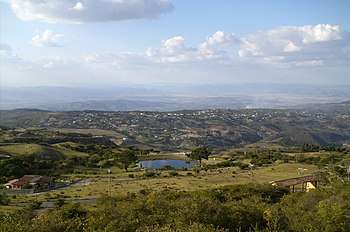
Guanare was founded on 3 November 1591 by João Fernandes de Leão Pacheco (1543-1593), a Portuguese captain from Portimão. Located at the edge of the Southwestern floodplains, near the Andes foothills, Guanare is in a region known for livestock and agricultural production. Guanare is also the location of one of the campuses of UNELLEZ
Javier Bertucci, Ivian Sarcos (Miss World 2011), and Martín Pérez are notable people from Guanare.
Climate
Nuestra Señora de Coromoto National Shrine
| Month | Jan | Feb | Mar | Apr | May | Jun | Jul | Aug | Sep | Oct | Nov | Dec | Year |
|---|---|---|---|---|---|---|---|---|---|---|---|---|---|
| Record high °C (°F) | 37.7 (99.9) |
38.2 (100.8) |
38.5 (101.3) |
37.8 (100.0) |
37.2 (99.0) |
34.3 (93.7) |
34.2 (93.6) |
34.7 (94.5) |
35.2 (95.4) |
34.9 (94.8) |
35.3 (95.5) |
35.9 (96.6) |
38.5 (101.3) |
| Average high °C (°F) | 33.1 (91.6) |
33.9 (93.0) |
34.2 (93.6) |
32.6 (90.7) |
30.9 (87.6) |
30.1 (86.2) |
30.0 (86.0) |
30.6 (87.1) |
31.3 (88.3) |
31.5 (88.7) |
31.8 (89.2) |
32.1 (89.8) |
31.8 (89.2) |
| Daily mean °C (°F) | 26.7 (80.1) |
27.6 (81.7) |
28.4 (83.1) |
27.9 (82.2) |
26.7 (80.1) |
26.0 (78.8) |
25.7 (78.3) |
26.1 (79.0) |
26.6 (79.9) |
26.7 (80.1) |
26.8 (80.2) |
26.3 (79.3) |
26.8 (80.2) |
| Average low °C (°F) | 20.2 (68.4) |
21.2 (70.2) |
22.6 (72.7) |
23.1 (73.6) |
22.5 (72.5) |
21.9 (71.4) |
21.4 (70.5) |
21.5 (70.7) |
21.9 (71.4) |
21.9 (71.4) |
21.7 (71.1) |
20.4 (68.7) |
21.7 (71.1) |
| Record low °C (°F) | 15.4 (59.7) |
15.4 (59.7) |
18.0 (64.4) |
19.4 (66.9) |
19.4 (66.9) |
17.2 (63.0) |
17.9 (64.2) |
17.7 (63.9) |
18.7 (65.7) |
19.0 (66.2) |
17.9 (64.2) |
15.3 (59.5) |
15.3 (59.5) |
| Average rainfall mm (inches) | 14 (0.6) |
17 (0.7) |
41 (1.6) |
131 (5.2) |
227 (8.9) |
245 (9.6) |
266 (10.5) |
200 (7.9) |
173 (6.8) |
172 (6.8) |
111 (4.4) |
33 (1.3) |
1,630 (64.2) |
| Average rainy days (≥ 1.0 mm) | 2.0 | 1.8 | 2.7 | 8.6 | 14.3 | 17.9 | 17.8 | 15.9 | 13.1 | 12.7 | 8.7 | 4.0 | 119.5 |
| Average relative humidity (%) | 67.5 | 64.5 | 64.0 | 69.5 | 76.0 | 78.5 | 78.5 | 78.0 | 77.5 | 76.5 | 76.0 | 72.5 | 73.3 |
| Mean monthly sunshine hours | 257.3 | 221.2 | 207.7 | 141.0 | 145.7 | 138.0 | 167.4 | 186.0 | 195.0 | 207.7 | 219.0 | 232.5 | 2,318.5 |
| Source 1: Instituto Nacional de Meteorología e Hidrología (INAMEH)[1][2] | |||||||||||||
| Source 2: NOAA (extremes, rainy days, and sun)[3] | |||||||||||||
References
- "Estadísticos Básicos Temperaturas y Humedades Relativas Máximas y Mínimas Medias" (PDF). INAMEH (in Spanish). Instituto Nacional de Meteorología e Hidrología. Archived from the original (pdf) on 15 June 2013. Retrieved 27 October 2012.
- "Estadísticos Básicos Temperaturas y Humedades Relativas Medias" (PDF). INAMEH (in Spanish). Instituto Nacional de Meteorología e Hidrología. Archived from the original (pdf) on 15 June 2013. Retrieved 27 October 2012.
- "Guanare Climate Normals 1961–1990". National Oceanic and Atmospheric Administration. Retrieved 12 August 2015.
Capital, state | ||||||
| ||||||
Bold indicates national capital. | ||||||
This article is issued from Wikipedia. The text is licensed under Creative Commons - Attribution - Sharealike. Additional terms may apply for the media files.