Granges-le-Bourg
Granges-le-Bourg is a commune in the Haute-Saône department in the region of Bourgogne-Franche-Comté in eastern France.
Granges-le-Bourg | |
|---|---|
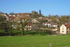 A general view of Granges-le-Bourg | |
 Coat of arms | |
Location of Granges-le-Bourg 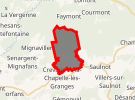
| |
 Granges-le-Bourg  Granges-le-Bourg | |
| Coordinates: 47°33′56″N 6°35′11″E | |
| Country | France |
| Region | Bourgogne-Franche-Comté |
| Department | Haute-Saône |
| Arrondissement | Lure |
| Canton | Villersexel |
| Area 1 | 10.35 km2 (4.00 sq mi) |
| Population (2017-01-01)[1] | 387 |
| • Density | 37/km2 (97/sq mi) |
| Time zone | UTC+01:00 (CET) |
| • Summer (DST) | UTC+02:00 (CEST) |
| INSEE/Postal code | 70277 /70400 |
| Elevation | 290–453 m (951–1,486 ft) |
| 1 French Land Register data, which excludes lakes, ponds, glaciers > 1 km2 (0.386 sq mi or 247 acres) and river estuaries. | |
Population
| Year | 1803 | 1851 | 1891 | 1946 | 1962 | 1968 | 1975 | 1982 | 1990 | 1999 | 2006 |
|---|---|---|---|---|---|---|---|---|---|---|---|
| Population | 374 | 567 | 346 | 174 | 312 | 287 | 356 | 330 | 306 | 313 | 347 |
| From the year 1962 on: No double counting—residents of multiple communes (e.g. students and military personnel) are counted only once. 2006: Provisional population (annual survey). | |||||||||||
References
- INSEE (in English)
- "Populations légales 2017". INSEE. Retrieved 6 January 2020.
| Wikimedia Commons has media related to Granges-le-Bourg. |
| Authority control |
|
|---|
This article is issued from Wikipedia. The text is licensed under Creative Commons - Attribution - Sharealike. Additional terms may apply for the media files.