Demangevelle
Demangevelle is a commune in the Haute-Saône department in the region of Bourgogne-Franche-Comté in eastern France.
Demangevelle | |
|---|---|
 A general view of Demangevelle | |
 Coat of arms | |
Location of Demangevelle 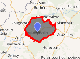
| |
 Demangevelle  Demangevelle | |
| Coordinates: 47°55′37″N 6°02′06″E | |
| Country | France |
| Region | Bourgogne-Franche-Comté |
| Department | Haute-Saône |
| Arrondissement | Vesoul |
| Canton | Jussey |
| Area 1 | 14.62 km2 (5.64 sq mi) |
| Population (2017-01-01)[1] | 278 |
| • Density | 19/km2 (49/sq mi) |
| Time zone | UTC+01:00 (CET) |
| • Summer (DST) | UTC+02:00 (CEST) |
| INSEE/Postal code | 70202 /70210 |
| Elevation | 222–350 m (728–1,148 ft) |
| 1 French Land Register data, which excludes lakes, ponds, glaciers > 1 km2 (0.386 sq mi or 247 acres) and river estuaries. | |
Geography
The Côney forms part of the commune's north-eastern border, flows south-westward through the middle of the commune, and forms part of the commune's south-western border.
External links
![]()
| Authority control |
|
|---|
This article is issued from Wikipedia. The text is licensed under Creative Commons - Attribution - Sharealike. Additional terms may apply for the media files.