Grand Banks of Newfoundland
The Grand Banks of Newfoundland are a series of underwater plateaus south-east of the island of Newfoundland on the North American continental shelf. The Grand Banks are one of the world's richest fishing grounds, supporting Atlantic cod, swordfish, haddock and capelin, as well as shellfish, seabirds and sea mammals.
Significance
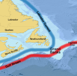
The Grand Banks of Newfoundland are a group of underwater plateaus south-east of Newfoundland on the North American continental shelf. These areas are relatively shallow, ranging from 15 to 91 metres (50 to 300 ft) in depth. The cold Labrador Current mixes with the warm waters of the Gulf Stream here, often causing extreme foggy conditions.
The mixing of these waters and the shape of the ocean bottom lifts nutrients to the surface. These conditions helped to create one of the richest fishing grounds in the world. Fish species include Atlantic cod, swordfish, haddock and capelin; shellfish include scallop and lobster. The area also supports large colonies of seabirds such as northern gannets, shear waters and sea ducks and various sea mammals such as seals, dolphins and whales.
Overfishing in the late 20th century caused the collapse of several species, particularly cod, leading to the closure of the Canadian Grand Banks fishery in 1992.
History
Extensive glaciation took place in the area of the Grand Banks during the last glacial maximum. By approximately 13,000 years ago the majority of the ice had melted, leaving the Grand Banks exposed as several islands extending for hundreds of kilometres. It is believed that rising sea-levels submerged these around 8,000 years ago.[1]

While no archaeological evidence for a European presence near the Grand Banks survives from the period between the short-lived Greenland Norse settlement at L'Anse aux Meadows in CE 1000 and John Cabot's transatlantic crossing in 1497, some evidence suggests that voyagers from Portugal,[2] the Basque Region[3] and England (especially those from Bristol)[4] and others[5] preceded Cabot.[6] In the 15th century some texts refer to a land called Bacalao, the land of the codfish, which is possibly Newfoundland. Within a few years of Cabot's voyage the existence of fishing grounds on the Grand Banks became generally known in Europe. Ships from France and Portugal pioneered fishing there, followed by vessels from Spain, while ships from England were scarce in the early years.[7] This soon changed, especially after Bernard Drake's Newfoundland Expedition in 1585, which virtually wiped out the Spanish and Portuguese fishing-industries in this area.[8] The fish stocks became important for the early European-settler economies of eastern Canada and New England.
On 18 November 1929, a major earthquake (known as the 1929 Grand Banks earthquake) on the southwestern part of the Grand Banks bordering the Laurentian Channel caused an underwater landslide which resulted in extensive damage to transatlantic cables and generated a rare Atlantic tsunami that struck the south coast of Newfoundland, claiming 29 lives on the Burin Peninsula.[9]
Technological advances in fishing (such as using large factory-ships and sonar), as well as geopolitical disputes over territorial sea and exclusive economic zone (EEZ) boundaries, led to overfishing and a serious decline in the fish stocks of the Grand Banks from around 1990. The Canadian Grand Banks fishery was closed in 1993.[10]
Canada's EEZ currently covers the majority of the Grand Banks except for the lucrative "nose" (eastern extremity, near the Flemish Cap) and "tail" (southern extremity) of the fishing bank. The 1783 Treaty of Paris gave the United States shared rights to fish in these waters, but that section of the Treaty is no longer in force. The exclusive economic zone of the French territory Saint Pierre and Miquelon occupies a pin-shaped section at the west edge of the Grand Banks, with the 22 kilometres (12 nmi; 14 mi) radius head of the pin surrounding the islands and the needle heading south for 348 km (188 nmi; 216 mi).
Research
Canada is currently performing the hydrographic and geological surveys necessary for claiming the entire continental shelf off eastern Canada, under the auspices of the latest United Nations Convention on the Law of the Sea (UNCLOS). Once this aspect of UNCLOS is ratified, Canada will presumably control these remaining parts of Grand Banks which are outside of its EEZ jurisdiction.
Petroleum reserves have also been discovered and a number of oil fields are under development in this region, most notably the Hibernia, Terra Nova, and White Rose projects; the harsh environment on the Grand Banks also led to the Ocean Ranger disaster.
Culture
Semi-fictional depictions of fishermen working on the Grand Banks can be found in Rudyard Kipling's novel Captains Courageous (1897) and in Sebastian Junger's non-fiction book The Perfect Storm (1997). The Grand Banks are also portrayed in the 1990 film The Hunt for Red October. Herman Melville described passing through the Banks as a young sailor on his first voyage in his autobiographical novel ‘’Redburn: His First Voyage’’ (1849), where he saw whales and a haunting shipwreck with weeks-dead sailors still on board. It is also featured in The Grey Seas Under, a non-fiction book by Canadian author Farley Mowat about the ocean-gong maritime salvage tug Foundation Franklin.
See also
References
- Shaw, John (2006). "Palaeogeography of Atlantic Canadian Continental Shelves from the Last Glacial Maximum to the Present, with an Emphasis on Flemish Cap". Journal of Northwest Atlantic Fishery Science. 37: 119–126. CiteSeerX 10.1.1.584.1310. doi:10.2960/J.v37.m565.
- Silva, A. J. M. (14–16 January 2015). Barata, F. T.; Rocha, J. M. (eds.). "The fable of the cod and the promised sea - About Portuguese traditions of bacalhau". Heritages and Memories from the Sea, Proceedings of the 1st International Conference of the UNESCO Chair in Intangible Heritage and Traditional Know-How: Linking Heritage. Évora: University of Evora: 130–143.
- Kurlansky, Mark (1997). "The Race to Codlandia". Cod: A Biography of the Fish that Changed the World. United States: Penguin Books. pp. 16–26. ISBN 978-0-14-027501-8.
- "European Exploration: From Earliest Times to 1497". Newfoundland and Labrador Heritage Web Site Project. Retrieved 2012-01-05.
- Seaver, Kirsten (2004). Maps, Myths, and Men: The Story of the Vinland Map. Stanford University Press. pp. 75–86. ISBN 978-0-8047-4962-6.
- Kurlansky, Mark (1997). "The Race to Codlandia". Cod: A Biography of the Fish that Changed the World. United States: Penguin Books. pp. 18–31. ISBN 978-0-14-027501-8.
- "European Exploration: From Earliest Times to 1497". Heritage Newfoundland and Labrador. Retrieved 28 January 2019.
- Prowse, D. W (2007). A History of Newfoundland from the English, Colonial and Foreign Record. Heritage Books. pp. 79–81. ISBN 978-078-842310-9.
- Yalçiner, Ahmet C.; Pelinovsky, Efim N.; Okal, Emile & Synolakis, Costas E., eds. (2003). Submarine Landslides and Tsunamis. Istanbul, Turkey: Springer Science+Business Media. pp. 177–178. ISBN 978-1-4020-1349-2. Retrieved 28 January 2019.
-
Zugarramurdi, Aurora; Parin, María A. & Lupin, Hector M. (1995). Economic Engineering Applied to the Fishery Industry. Rome: Food and Agriculture Organization of the United Nations. p. 11. ISBN 92-5103738-8. Retrieved 8 November 2019.
In 1993, fishing in the Grand Banks off Canada was closed due to overfishing.
External links
- The Grand Banks and the Flemish Cap
- Government response to the standing committee on fisheries and oceans' tenth report
- Watch Cries from the Deep—a Jacques Cousteau documentary on the Grand Banks
Fishing industry by region | ||
|---|---|---|
| By country |  | |
| Fishing banks | ||
| By species | ||
| Other areas | ||
| Fisheries | 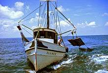 | |
|---|---|---|
| Fishing | ||
| Industry |
| |
| Recreation | ||
| Techniques | ||
| Tackle | ||
| Locations |
| |