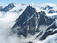
Graian Alps
The Graian Alps (Italian: Alpi Graie [ˈalpi ˈɡraːje]; French: Alpes grées [alp ɡʁe]) are a mountain range in the western part of the Alps.
| Graian Alps | |
|---|---|
| French: Alpes grées, Italian: Alpi Graie | |
.png) Graian Alps (in red) within the Alps.
The borders of the range according to Partizione delle Alpi & SOIUSA | |
| Highest point | |
| Peak | Mont Blanc |
| Elevation | 4,810.45 m (15,782.3 ft) |
| Coordinates | 45°50′1″N 6°51′54″E |
| Geography | |
| Countries | France, Italy and Switzerland |
| Provinces/Regions | Auvergne-Rhône-Alpes, Piedmont, Aosta Valley and Valais |
| Range coordinates | 45°30′N 7°10′E |
| Parent range | Alps |
| Borders on | List
|
| Geology | |
| Orogeny | Alpine orogeny |
Etymology
The name Graie comes from the Graioceli Celtic tribe, which dwelled in the area surrounding the Mont Cenis pass and the Viù valley.[1] Other sources claim that the name comes from the Celtic "Graig" meaning rock/stone, literally the Rocky Mountains[2]
Geography
The Graian Alps are located in France (Auvergne-Rhône-Alpes), Italy (Piedmont and the Aosta Valley), and Switzerland (western Valais).
The French side of the Graian Alps is drained by the river Isère (Tarentaise valley) and its tributary Arc (Maurienne valley), and by the Arve. The Italian side is drained by the rivers Dora Baltea, Orco and Stura di Lanzo, tributaries of the Po.
The Graian Alps can also be divided into the following four groups:
- the Mont Blanc group (north of the Little St Bernard Pass), including the Beaufortain Massif
- the Central group (the watershed between the Little St Bernard Pass and the Col du Mont Cenis)
- the Western or French group,
- and the Eastern or Italian group.
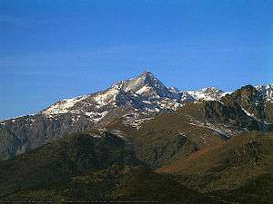
Peaks
The main peaks of the Graian Alps are:
Mont Blanc group

| Name | metres | feet |
|---|---|---|
| Mont Blanc | 4,810.45[3] | 15,782 |
| Mont Maudit | 4,471 | 14,669 |
| Dôme du Goûter | 4,331 | 14,210 |
| Grandes Jorasses | 4,205 | 13,797 |
| Aiguille Verte | 4,127 | 13,541 |
| Aiguille de Bionnassay | 4,066 | 13,341 |
| Dent du Géant | 4,013 | 13,166 |
| Aiguille de Tré la Tête | 3,911 | 12,832 |
| Aiguille d'Argentière | 3,902 | 12,802 |
| Aiguille de Triolet | 3,876 | 12,717 |
| Aiguille du Midi | 3,843 | 12,609 |
| Tour Noir | 3,836 | 12,586 |
| Aiguille des Glaciers | 3,834 | 12,579 |
| Mont Dolent | 3,823 | 12,543 |
| Aiguille du Chardonnet | 3,822 | 12,540 |
| Aiguille du Dru | 3,754 | 12,316 |
| Dômes de Miage | 3,688 | 12,100 |
| Aiguille du Tour | 3,540 | 11,615 |
| Aiguille du Grépon | 3,502 | 11,489 |
| Aiguille des Charmoz | 3,442 | 11,293 |
| Aiguille du Tacul | 3,438 | 11,280 |
| Pointe d'Orny | 3,274 | 10,742 |
| Mont Favre | 3,259 | 10,693 |
| Tour Sallière | 3,227 | 10,588 |
| Pointe de Léchaud | 3,127 | 10,260 |
| Mont Buet | 3,109 | 10,201 |
| Mont Ruan | 3,078 | 10,099 |
| Roignais | 2,995 | 9,826 |
| Pic de Tenneverge | 2,982 | 9,784 |
| Aiguille du Belvédère (Aigs Rouges) | 2,966 | 9,731 |
| Crammont | 2,737 | 8,980 |
| Pointe des Fours | 2,719 | 8,921 |
| Pointe du Colloney | 2,692 | 8,832 |
| Catogne | 2,599 | 8,527 |
| Mont Joly | 2,527 | 8,291 |
| Brevent | 2,525 | 8,284 |
| Pointe de Sales | 2,494 | 8,183 |
| Aiguille de Varan | 2,488 | 8,163 |
| Aiguille Croche | 2,487 | 8,159 |
| Mont Chetif | 2,343 | 7,687 |
Central group
| Name | metres | feet | Name | metres | feet | |
|---|---|---|---|---|---|---|
| Pointe de Charbonnel | 3760 | 12,336 | Grande Aiguille Rousse | 3482 | 11,424 | |
| Aiguille de la Grande Sassière | 3751 | 12,306 | Granta-Parey | 3473 | 11,395 | |
| Uia di Ciamarella | 3676 | 12,061 | Roc du Moulinet | 3469 | 11,382 | |
| Albaron | 3638 | 11,936 | Aiguille Pers | 3451 | 11,323 | |
| Pointe de Ronce | 3618 | 11,871 | Cima dell' Auille?? | 3446 | 11,306 | |
| Levanna | 3619 | 11,874 | Pointe de la Galise | 3345 | 10,975 | |
| Bec de l'Invergnan | 3608 | 11,838 | Pointe de la Traversière | 3341 | 10,962 | |
| Tsanteleina | 3606 | 11,831 | Ormelune/Pointe d'Archeboc | 3283 | 10,771 | |
| Bessanèse | 3597 | 11,801 | Signal du Mont Iseran | 3241 | 10,634 | |
| Croce Rossa | 3566 | 11,703 | Grand Assaly | 3174 | 10,413 | |
| Punta d'Arnas | 3540 | 11,615 | Torre d'Ovarda | 3075 | 10,089 | |
| Rocciamelone | 3537 | 11,605 | Dôme de Val d'Isère | 3033 | 9,951 | |
| Punta Chalanson | 3530 | 11,582 | Uia di Mondrone | 2964 | 9,725 | |
| Grande Traversière | 3495 | 11,467 | Punta Lunella | 2272 | 7,454 | |
| Testa del Rutor | 3486 | 11,438 | Monte Civrari | 2302 | 7,553 |
Eastern group
| Name | metres | feet | Name | metres | feet | |
|---|---|---|---|---|---|---|
| Gran Paradiso | 4061 | 13,324 | Grand Nomenon | 3513 | 11,444 | |
| Grivola | 3969 | 13,022 | Mont Tout Blanc | 3438 | 11,280 | |
| Herbétet | 3778 | 12,396 | Punta Sengie | 3408 | 11,182 | |
| Torre del Gran San Pietro | 3692 | 12,113 | Punta Lavina | 3308 | 10,854 | |
| Ciarforon | 3665 | 12,025 | Rosa dei Banchi | 3164 | 10,381 | |
| Roccia Viva | 3650 | 11,976 | Becca di Nona | 3142 | 10,309 | |
| Becca di Gay | 3623 | 11,887 | Punta Pousset | 3046 | 9,994 | |
| Monte Emilius | 3559 | 11,677 | Monte Colombo | 2848 | 9,344 | |
| Punta Tersiva | 3513 | 11,526 | Monte Marzo | 2750 | 9,023 |
Western group
| Name | metres | feet | Name | metres | feet | |
|---|---|---|---|---|---|---|
| Grande Casse | 3855 | 12,648 | Pointe de l'Échelle | 3422 | 11,227 | |
| Mont Pourri | 3779 | 12,398 | Bellecôte | 3417 | 11,211 | |
| Dent Parrachée | 3697 | 12,129 | Pointes de la Gliere | 3386 | 11,109 | |
| Grande Motte | 3653 | 11,985 | Pointe de Méan Martin | 3337 | 10,949 | |
| Dôme de l'Arpont | 3601 | 11,808 | Roche Chevrière | 3252 | 10,669 | |
| Dôme de Chasseforêt | 3586 | 11,765 | Aiguille Rouge | 3227 | 10,584 | |
| Aiguille de Péclet | 3566 | 11,700 | Pointe de la Réchasse | 3223 | 10,575 | |
| Aiguille de Polset | 3538 | 11,608 | Petit Mont Blanc de Pralognan | 2685 | 8809 | |
| Pointe de la Sana | 3436 | 11,273 | Mont Jovet | 2563 | 8409 |
Passes
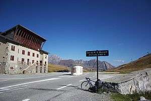
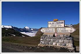
The main passes of the Graian Alps are shown in the table below. The group in which the pass is located is indicated with "MB" for Mont Blanc group, "C" for Central group, "E" for Eastern group, and "W" for Western group.
| name | location | group | type | elevation (m/ft) | |
|---|---|---|---|---|---|
| Col de la Brenva | Courmayeur to Chamonix | MB | snow | 4,333 | 14,217 |
| Col de Triolet | Chamonix to Courmayeur | MB | snow | 3,691 | 12,110 |
| Col d'Argentière | Chamonix to Orsières | MB | snow | 3,516 | 11,536 |
| Col de la Grande Rousse | Rhêmes Valley to Valgrisenche | C | snow | 3500 | 11,483 |
| Col de Talefre | Chamonix to Courmayeur | MB | snow | 3,484 | 11,430 |
| Col de Gebroulaz | Modane to Méribel | W | snow | 3470 | 11,385 |
| Col de Monel | Cogne to Locana | E | snow | 3428 | 11,247 |
| Col de Miage | Les Contamines to Courmayeur | MB | snow | 3,376 | 11,077 |
| Col du Géant | Chamonix to Courmayeur | MB | snow | 3,371 | 11,060 |
| Col du Grand Paradis | Ceresole Reale to Valsavarenche | E | snow | 3349 | 10,988 |
| Col du Charforon | Ceresole Reale to Valsavarenche | E | snow | 3331 | 10,929 |
| Col de Teleccio | Cogne to Locana | E | snow | 3326 | 10,913 |
| Col du Chardonnet | Chamonix to Orsières | MB | snow | 3,325 | 10,909 |
| Col de Lauzon | Cogne to the Valsavarenche | E | bridle path | 3301 | 10,831 |
| Col du Bouquetin | Bonneval-sur-Arc to Val d'Isère | C | snow | 3300 | 10,827 |
| Col de St Grat | Valgrisenche to La Thuile | C | snow | 3300 | 10,827 |
| Col du Tour | Chamonix to Orsières | MB | snow | 3,280 | 10,762 |
| Fenêtre de Saleinaz | Saleinaz Glacier to Trient Glacier | MB | snow | 3,264 | 10,709 |
| Col de l'Herbetet | Cogne to Valsavarenche | E | snow | 3257 | 10,686 |
| Col du Collerin | Bessans to Balme | C | snow | 3202 | 10,506 |
| Col du Grand Etret | Ceresole Reale to Valsavaranche | E | snow | 3158 | 10,361 |
| Col de Bassac | Rhêmes Valley to Valgrisenche | C | snow | 3153 | 10,345 |
| Col du Carro | Bonneval-sur-Arc to Ceresole Reale | C | snow | 3140 | 10,302 |
| Col d'Arbole | Cogne to Brissogne | E | snow | 3137 | 10,292 |
| Col de la Goletta | Val d'Isère to the Rhêmes Valley | C | snow | 3120 | 10,237 |
| Col de Rhêmes | Val d'Isère to the Rhêmes Valley | C | snow | 3101 | 10,174 |
| Col de la Grande Casse | Pralognan to Termignon | W | snow | 3100 | 10,171 |
| Col de Sea | Bonneval-sur-Arc to Forno Alpi Graie | C | snow | 3083 | 10,115 |
| Col de l'Autaret | Bessans to Usseglio | C | footpath | 3070 | 10,073 |
| Col de Girard | Bonneval-sur-Arc to Forno Alpi Graie | C | snow | 3044 | 9987 |
| Col Rosset | Valsavarenche to the Rhêmes Valley | C | bridle path | 3024 | 9922 |
| Col d'Arnas | Bessans to Balme | C | snow | 3014 | 9889 |
| Col de la Galise | Ceresole Reale to Val d'Isère | C | snow | 2998 | 9836 |
| Col de Sort | Valsavarenche to the Rhêmes Valley | E | bridle path | 2967 | 9735 |
| Quecees de Tignes | Val d'Isère to Termignon | W | snow | 2940 | 9646 |
| Col della Nouva | Cogne to Pont Canavese | E | bridle path | 2933 | 9623 |
| Col de Breuil | Bourg-Saint-Maurice to La Thuile | MB | snow | 2,879 | 9,446 |
| Col de Garin | Aosta to Cogne | E | footpath | 2868 | 9411 |
| Collarin d'Arnas | Balme to Usseglio | C | snow | 2850 | 9351 |
| Colle della Finestra | Rhêmes Valley to the Valgrisenche | C | footpath | 2847 | 9341 |
| Fenêtre de Champorcher | Cogne to Champorcher | E | bridle path | 2838 | 9311 |
| Col Vaudet | Sainte-Foy-Tarentaise to the Valgrisenche | C | footpath | 2836 | 9305 |
| Col de Bardoney | Cogne to Pont Canavese | E | snow | 2833 | 9295 |
| Col de Chaviere | Modane to Pralognan | W | footpath | 2806 | 9206 |
| Col de la Leisse | Tignes to Termignon | W | snow | 2780 | 9121 |
| Col de l'Iseran | Bonneval-sur-Arc to Val d'Isère | C | road | 2769 | 9085 |
| Ghicet di Sea | Balme to Forno Alpi Graie | C | footpath | 2735 | 8973 |
| Col de la Sachette | Tignes to Bourg-Saint-Maurice | W | footpath | 2729 | 8954 |
| Col du Palet | Tignes to Moûtiers or Bourg St Maurice | W | bridle path | 2658 | 8721 |
| Col du Mont | Ste Foy to the Valgrisenche | C | bridle path | 2646 | 8681 |
| Col du Nivolet | Ceresole Reale to the Valsavarenche | E | road | 2641 | 8665 |
| Colle della Crocetta | Ceresole Reale to Forno Alpi Graie | C | bridle path | 2636 | 8649 |
| Col de la Platiere | Saint-Jean-de-Maurienne to Moûtiers | W | bridle path | 2600 | 8531 |
| Col du Mont Tondu | Les Contamines to Courmayeur | MB | snow | 2,590 | 8,498 |
| Col Ferret | Courmayeur to Orsières | MB | bridle path | 2,533 | 8,311 |
| Col de la Vanoise | Pralognan to Termignon | W | bridle path | 2527 | 8291 |
| Col de la Seigne | Les Chapieux to Courmayeur | MB | bridle path | 2,512 | 8,242 |
| Col de Susanfe | Champéry to Salvan | MB | footpath | 2,500 | 8,202 |
| Col du Bonhomme | Contamines to Les Chapieux | MB | bridle path | 2,483 | 8,147 |
| Col de Sageroux | Sixt to Champéry | MB | footpath | 2,413 | 7,917 |
| Col des Encombres | Saint-Michel-de-Maurienne to Moûtiers | W | bridle path | 2337 | 7668 |
| Col d'Anterne | Sixt to Servoz | MB | bridle path | 2,263 | 7,425 |
| Col de Balme | Chamonix to the Trient Valley | MB | bridle path | 2,201 | 7,221 |
| Little St Bernard Pass | Aosta to Moûtiers | C | road | 2188 | 7179 |
| Mont Cenis | Modane to Susa | C | road | 2083 | 6827 |
| Col de la Madeleine | La Chambre to Moûtiers | W | road | 1993 | 6509 |
| Colle Checrouit | Courmayeur to the Lac de Combal | MB | bridle path | 1,960 | 6,431 |
| Col de Voza | Chamonix to Les Contamines | MB | bridle path | 1,675 | 5,496 |
| Col de la Forclaz (F) | Chamonix to Saint-Gervais | MB | bridle path | 1,556 | 5,105 |
| Col de la Forclaz (CH) | Argentière to Martigny | MB | road | 1,520 | 4,987 |
Nature conservation
The western group contains the Vanoise National Park, established in 1972 and covering 1250 km²;[4] the eastern group contains the Gran Paradiso National Park, the oldest Italian national park.[5] Also on the Italian side is located the Parco Regionale del Monte Avic, a nature park of 5,747 ha established by Regione Valle d'Aosta.[6]
Maps
- Italian official cartography (Istituto Geografico Militare - IGM); on-line version: www.pcn.minambiente.it
- French official cartography (Institut Géographique National - IGN); on-line version: www.geoportail.fr
- Swiss official cartography (Swiss Federal Office of Topography - Swisstopo); on-line version: map.geo.admin.ch
See also
- Mont Blanc Massif
- Vanoise Massif
- Swiss Alps
References

- Il territorio piemontese nel periodo preromano, on-line text on www.leganordavigliana.com
- "Revue celtique de Toronto, Tome III" (PDF). Archived from the original (PDF) on 2014-08-10. Retrieved 2014-08-11.
- Mont Blanc shrinks by 45cm in two years
- Les chiffres clés du Parc national de la Vanoise, National park official web-site www.parcnational-vanoise.fr Archived 2012-01-21 at the Wayback Machine (accessed on April 2012)
- Il parco compie 90 anni, National park official web-site www.pngp.it (accessed on April 2012)
- Parco del Mont Avic, home page on www.montavic.info (accessed on April 2012)
External links
| Wikimedia Commons has media related to Graian Alps. |
- Ascents in Gran Paradiso group - Czech and English
- Graian Alps on Summitpost - English