Monte Civrari
The Monte Civrari is a mountain of the Graian Alps, with an elevation of 2,302 m[1].
| Monte Civrari | |
|---|---|
| Punta Imperatoria | |
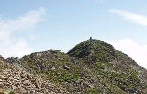 The summit of Monte Civrari (Punta Imperatoria) | |
| Highest point | |
| Elevation | 2,302 m (7,552 ft) |
| Prominence | 414 m (1,358 ft) |
| Listing | Alpine mountains 2000-2499 m |
| Coordinates | 45°11′31″N 7°19′39″E |
| Geography | |
 Monte Civrari Location in the Alps | |
| Location | Province of Turin, Italy |
| Parent range | Graian Alps |
| Climbing | |
| Easiest route | Hiking from Colle del Colombardo or Niquidetto |
Etymology
The name Civrari means goats’ mountain (from ciavra, the Piedmontese word for goat).[2] There is strong evidence that the area was in the past widely exploited for goat grazing.[3]
Geography

The Civrari is not an isolated peak but a small massif. Its main summit is named Punta Imperatoria; in the massif are also located Torretta del Prete (2.264 m), Punta della Croce (2.236 m), Monte Rognoso (1.952 m) and, in a wider sense, also the Punte di Costafiorita and Punta Sourela (1.777 m). On the summit of Punta Imperatoria stands a trigpoint of the IGM named Monte Civrari (code 055037).[4]
Punta Imperatoria is located slightly N of the ridge dividing Val Susa from Val di Viù, and stands on the border between the comunes of Viù and Lemie (both in the Metropolitan City of Turin).
SOIUSA classification
According to the SOIUSA (International Standardized Mountain Subdivision of the Alps) the mountain can be classified in the following way:[5]
- main part = Western Alps
- major sector = North Western Alps
- section = Graian Alps
- subsection = Southern Graian Alps
- supergroup = catena Rocciamelone-Charbonel
- group = gruppo del Rocciamelone
- subgroup = cresta Lunella-Arpone
- code = I/B-7.I-A.2.b
Access to the summit
The easiest route for the summit is a footpath starting from Niquidetto or from the Colle del Colombardo, a mountain pass which connects Viù and Condove and can be reached with 4wd vehicles.
Maps
- Italian official cartography (Istituto Geografico Militare - IGM); on-line version: www.pcn.minambiente.it
- I.G.C. (Istituto Geografico Centrale): Carta dei sentieri e dei rifugi 1:50.000 scale n.2 Valli di Lanzo e Moncenisio, and 1:25.000 scale n.110 Basse valli di Lanzo
Bibliography
- Alpi Graie meridionali, Giulio Berutto e Lino Fornelli, Club Alpino Italiano, 1980
Notes
- Geoportale IGM on www.pcn.minambiente.it
- Gallenga, Antonio Napoleone (1856). Storia del Piemonte dai primi tempi alla Pace di Parigi (in Italian). 1. Eredi Botta editore. p. 11.
- Clavarino, Luigi (1867). Saggio di corografia: statistica e storica delle Valli di Lanzo (in Italian). Stamperia della Gazzetta del popolo. p. 133.
- Punti Geodetici, IGM, on www.igmi.org Archived 2012-06-05 at the Wayback Machine (consultato nel marzo 2011)
- Marazzi, Sergio (2005). Atlante Orografico delle Alpi. SOIUSA (in Italian). Priuli & Verlucca. p. 134. ISBN 978-88-8068-273-8.
Image gallery
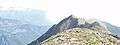 Torretta del Prete
.jpg) Punta della Croce
Punta della Croce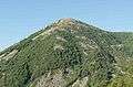 Monte Rognoso
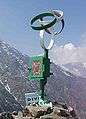 Punta Sourela summit
External links
- Monte Civrari: 360° panoramic image from the summit on pano.ica-net.it
- Monte Civrari-Punta Imperatoria, Italy on peakbagger.com
See also
![]()