Courmayeur
Courmayeur (French: [kuʁmajœʁ]; Valdôtain: Croméyeui) is a town and comune in northern Italy, in the autonomous region of Aosta Valley.
Courmayeur Croméyeui (Arpitan) | |
|---|---|
| Comune di Courmayeur Commune de Courmayeur | |
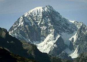
 Courmayeur from the Torino Hut in August 2009 | |
.svg.png) Coat of arms | |
Location of Courmayeur 
| |
 Courmayeur Location of Courmayeur in Italy 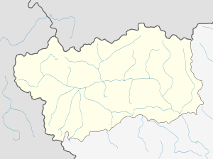 Courmayeur Courmayeur (Aosta Valley) | |
| Coordinates: 45°47′N 06°58′E | |
| Country | Italy |
| Region | Aosta Valley |
| Frazioni | Dolonne, Entrèves, La Palud, Villair Dessous, Villair Dessus, Larzey, Entrelevie, La Villette, La Saxe, Planpincieux, Lavachey, La Visaille, Arnouvaz. |
| Government | |
| • Mayor | Stefano Miserocchi (Independent) |
| Area | |
| • Total | 210 km2 (80 sq mi) |
| Highest elevation | 4,810 m (15,780 ft) |
| Lowest elevation | 1,224 m (4,016 ft) |
| Population (2010)[2] | |
| • Total | 2,870 |
| • Density | 14/km2 (35/sq mi) |
| Demonym(s) | Courmayeureins |
| Time zone | UTC+1 (CET) |
| • Summer (DST) | UTC+2 (CEST) |
| Postal code | 11013 |
| Dialing code | 0165 |
| Patron saint | St. Pantaleo |
| Saint day | July 27 |
| Website | comune.courmayeur.ao.it |
Geography
At an elevation of 1,224 m (4,016 ft) above sea level, it is located at the foot of the southern side of Mont Blanc, at 4,810 m (15,781 ft) the highest point in the Alps and western Europe (see Seven Summits), and is crossed by the Dora Baltea (fr. Doire baltée) river.
Courmayeur shares administration of Mont Blanc with its neighboring municipality of Saint-Gervais-les-Bains in France, and is consequently able to claim the title of highest commune in Italy.
Courmayeur also shares access to the glacial ski run of the Vallée Blanche with another French town, Chamonix, which sits at the opposite, northern, side of the Mont Blanc massif.
History
The toponym Courmayeur has been mentioned as Curia majori (1233-1381), Corte Maggiore (1620), Cormoyeu (1648), Cormaior (1680), Cormaior (Vissher, 1695), Cormaggior (L'Isle, 1707), Cormaior (Stagnoni, 1772) and Cormaieur (Martinel, 1799). Nowadays' toponym was first confirmed by Édouard Aubert (La Vallée d'Aoste, 1860), Joseph-Marie Henry (Histoire populaire de la Vallée d'Aoste, 1929) and Amé Gorret (Guide de la Vallée d'Aoste, 1877).

It became a popular tourist destination when alpinism arose, thanks to its proximity to Mont Blanc.
Under the Fascist regime and its "Italianist" rule, the town was briefly renamed Cormaiore. Courmayeur was reestablished in 1948 alongside all other French toponyms in the Aosta Valley.
In 2013 according to the regional law 61 (Dénomination officielle des communes de la Vallée d'Aoste et protection de la toponymie locale) a referendum was carried out to change the official name into Courmayeur-Mont-Blanc,[3] but there was no sufficient support.
Landmarks


Courmayeur is cited as "Italy's best all-round ski resort",[4] and contains the Alpine Botanical Garden Saussurea, which describes itself as Europe's highest botanical garden.[5] The Church of Saint-Pantaléon dates to the 18th century.
In the summer months Courmayeur is a popular destination for hikers.[6] The nearby village of La Palud is the base station of the Skyway Monte Bianco, the cable car to the Pointe Helbronner. This links to the Vallée Blanche Aerial Tramway going to the Aiguille du Midi, which connects to the Téléphérique de l'Aiguille du Midi, the cable car from Chamonix.
Notre Dame de Guérison sanctuary stands at the foot out Mont Chétif.
Sister cities

References
- "Superficie di Comuni Province e Regioni italiane al 9 ottobre 2011". Istat. Retrieved 16 March 2019.
- "Popolazione Residente al 1° Gennaio 2018". Istat. Retrieved 16 March 2019.
- C’est au tour de Courmayeur de vouloir s’appeler "Mont-Blanc"
- Porter (January 1990). Italy, 1990. Prentice Hall PTR. p. 415. ISBN 978-0-13-217357-5.
- Vay, David Le (4 August 2014). A Tour of Mont Blanc: And other circuitous adventures in Italy, France and Switzerland. Summersdale Publishers Limited. p. 66. ISBN 978-1-78372-215-0.
- Belford, Ros (1 March 2010). Back Roads Italy. Dorling Kindersley Limited. p. 38. ISBN 978-1-4053-4531-6.
External links
| Wikimedia Commons has media related to Courmayeur. |

- Official website (in Italian and French)


| Authority control |
|
|---|