Gorontalo (city)
Gorontalo is a city and the capital of the Gorontalo Province, Indonesia. It is on the island of Sulawesi. The city has an area of 64.79 km² and a population of 179,991 at the 2010 Census.[1]
Gorontalo | |
|---|---|
| Gorontalo City Kota Gorontalo | |
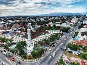 A view of Gorontalo | |
Seal | |
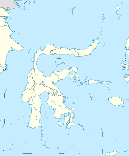
 Location within Gorontalo Province | |
| Coordinates: 0°32′N 123°4′E | |
| Country | |
| Province | |
| Founded | 18 March 1728 |
| Government | |
| • Mayor | Marten A Taha |
| • Vice Mayor | Budi Doku |
| Area | |
| • Total | 64.79 km2 (25.02 sq mi) |
| Elevation | 9 m (30 ft) |
| Population (2010 Census) | |
| • Total | 179,991 |
| Time zone | UTC+8 (Indonesia Central Time) |
| Area code | (+62) 435 |
| Website | www |

Geography
Gorontalo shares its borders with Bone Bolango Regency (to the north and east), Tomini Gulf (to the south), and Gorontalo Regency (to the west). Its elevation does not rise above 500 meters (1640 feet) above mean sea level and the average temperature is 26.5 °C.
Climate
Gorontalo has a relatively dry tropical rainforest climate (Af) with moderate rainfall year-round.
| Climate data for Gorontalo | |||||||||||||
|---|---|---|---|---|---|---|---|---|---|---|---|---|---|
| Month | Jan | Feb | Mar | Apr | May | Jun | Jul | Aug | Sep | Oct | Nov | Dec | Year |
| Average high °C (°F) | 30.8 (87.4) |
30.8 (87.4) |
31.2 (88.2) |
31.9 (89.4) |
31.7 (89.1) |
31.0 (87.8) |
30.8 (87.4) |
31.4 (88.5) |
32.1 (89.8) |
32.5 (90.5) |
32.2 (90.0) |
31.5 (88.7) |
31.5 (88.7) |
| Daily mean °C (°F) | 26.7 (80.1) |
26.6 (79.9) |
26.9 (80.4) |
27.4 (81.3) |
27.4 (81.3) |
26.8 (80.2) |
26.6 (79.9) |
26.8 (80.2) |
27.1 (80.8) |
27.3 (81.1) |
27.5 (81.5) |
27.2 (81.0) |
27.0 (80.6) |
| Average low °C (°F) | 22.6 (72.7) |
22.5 (72.5) |
22.7 (72.9) |
22.9 (73.2) |
23.2 (73.8) |
22.7 (72.9) |
22.5 (72.5) |
22.3 (72.1) |
22.1 (71.8) |
22.2 (72.0) |
22.9 (73.2) |
22.9 (73.2) |
22.6 (72.7) |
| Average precipitation mm (inches) | 101 (4.0) |
95 (3.7) |
101 (4.0) |
105 (4.1) |
148 (5.8) |
133 (5.2) |
117 (4.6) |
74 (2.9) |
67 (2.6) |
99 (3.9) |
128 (5.0) |
117 (4.6) |
1,285 (50.4) |
| Source: [2] | |||||||||||||
Infrastructure
The largest hospital on Gorontalo is the Aloei Saboe Hospital.
Culinary
Culinary in Gorontalo range from seafood to corn (as these can be easily found). Famous food "binthe Biluhuta" which is made out of corn, shredded coconut, basil, and some fish or dried prawns. Other than that, grilled tuna with chilly sauce is very popular.
Districts
In 2010 the city was composed of six districts (kecamatan),[3] listed below with their 2010 Census Populations:[1]
- Kota Selatan (South City) district - 35,988
- Kota Utara (North City) district - 33,149
- Kota Barat (West City) district - 20,220
- Kota Timur (East City) district - 42,155
- Kota Tengah (Central City) district - 27,047
- Dungingi district - 21,568
Since 2010, three additional districts have been created - Dumbo Raya, Hulonthalangi and Sipatana.
Sister cities
- Mamuju, Indonesia
- Bengkulu City, Indonesia
References
- Biro Pusat Statistik, Jakarta, 2011.
- https://en.climate-data.org/location/4806
- "Pemerintah Kota Gorontalo". 2009. Archived from the original on 12 May 2010. Retrieved 2 March 2011.
External links
| Wikivoyage has a travel guide for Gorontalo (city). |