Ghat Roads
Ghat Roads are access routes into the mountainous Western and Eastern Ghats, mountain ranges of the Indian Subcontinent. These roads are remarkable feats of engineering and most were constructed during the British Raj. Ghat roads were built to connect to the famous Hill Stations established in the mountains for residents to avoid summer heat. They generally served to connect coastal (sea side) areas with the upper region Deccan plateau of the Indian Subcontinent.
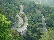
There are many roads in India which can be classed as Ghat Roads.The Indian state of Tamil Nadu has most of the ghat roads.
Andhra Pradesh
TIRUMALA GHATS
The Ghat roads between Tirupati and Tirumala to pilgrim Tirumala Venkateswara Temple. They are in Seshachalam Hills range in Pūrva Ghaṭ
SRISAILAM GHATs
It is one of the very dangerous ghat road in eastern ghats. It is connected with the state of Andhra Pradesh and Telangana. There are two roads dornala to srisailam another one is bramanapalli to srisailam.
KADAPPA GHATS
It is situated on southern nallamala forest on Chennai to Kadappa national highway between Kadappa and Rayachotty.Road is very scenic during monsoon season.
NANDYAL GHAT ROAD
It is situated on northern Nallamala Forest, between Giddalur and Nandyal,the road connects Kurnool and Kadappa districts.
NIRMAL GHATS
It is situated in Adilabad district of Telangana region.It is locally called as Mahaboob ghats and it stretches of 10 km.The road is scenic and surrounded by dense Forest and crosses two falls namely Poccheru and Kuntala falls.It is located at 220 km from Hyderabad.
HORSLEY GHATS
Horsley hills is a hill station in Chittor district.Madanappally is the nearest town to Horsley hills.Ghat road starts from Madanappally.It has 12 has hairpin bends.
ARAKU VALLEY GHATS
It is a hill station in Vishakapatnam district of Coastal Andhra region.It has several ghat roads.Lambasingi ghat road is very famous and scenic.
Karnataka
The Western Ghats lie in between coastal plains adjoining the Arabian Sea and the Deccan Plateau. There are many ghat roads which connect Karavali districts with that of Malenadu and Bayaluseemae region. Most of these ghats are very scenic during monsoon (rainy) season in the months of June, July and August. A few are mentioned below.
Agumbe (Kannada: ಆಗುಂಬೆ) is a small village located in Shimoga district, Thirthahalli taluk. Agumbe lies in a hilly, wet region of the Western Ghat mountains. Agumbe connects Udupi district (Udipi) with Shivamogga (Shimoga).[1] There is a sunset point at Agumbe ghats to view sunset in the evening. Agumbe ghat can be foggy during rains.Only small vehicles are allowed in Agumbe ghat like mini buses, passenger cars etc.
Charmadi. Charmadi ghat lies on the border of Dakshina Kannada and Chickmagalore districts of Karunadu. The national highway NH-73 (Old NH-234) passes through this ghat.[2]
Shiradi. Shirady ghat connects the coastal district of Dakshina Kannada with the Hassan district. The National highway 75 (Old NH-48) road starts from the seaport city of Mangaluru in Dakshina Kannada district and connects to Karnataka state capital Bengaluru.[3]
Hulikal. Hulikal ghat or Balebare ghat connects Udupi district with Shivamogga district, both in Karnataka state of India (Bharath). People and vehicles can travel from the low-lying coastal region to Deccan plateau through Western ghats.[4]
Sampaje. Sampaje ghat road is a part of Mangalooru to Mysuru highway via Madikeri.
Bisle. Bisle ghat road connects the temple town of Kukke Subramanya in Dakshina Kannada district, which lies below the western ghats, to Sakleshpura above the western ghats.[5] This ghat road is less used because of the dense forest and danger from wild elephants on the road. The Bisle ghat road lies in the Elephant corridor of Western Ghats ie; paths followed by the wild elephants in search of water and food sources.
Devimane Ghat. Devimane ghat lies in Uttara Kannada district of Karnataka state, Bharat. It connects the coastal town of Kumta with Sirsi town above the western ghat.[6] Many KSRTC buses run through this ghat section. There is a Hindu temple at Devimane village.
Arebail Ghat . Arebail ghat is situated in Uttara Kannada district of Karnataka state, India. Arebail ghat is in between road connecting Ankola which is down the ghat to Hubballi( Hubli) above the ghat on deccan plateau via the town of Yellapura. The road is known by national highway 52.
Male mahadeshwara betta : Kannada (ಮಲೆ ಮಹದೇಶ್ವರ ಬೆಟ್ಟ )Mm hills ghat road is situated in hanur taluk, chamarajanagara district of Karnataka state, India. it belongs to the Eastern ghats of India . MM hills ghat road connecting kollegal in karnataka and mettur in Tamil Nadu.
Maharashtra
Amboli Ghat. This ghat connects Sawantwadi to Kolhapur and Belagavi in Karnataka. Amboli, Sindhudurg is a hill station on this ghat.
Bhor Ghat. The road connecting city of Mumbai to the city of Pune both in state of Maharashtra, Bharat passes through this ghat.
Kasara Ghat. This ghat is a passage through western ghats (Sahyadri) range of mountains for travelling from Thane city to Nasik city.
Malshej Ghat . A passage for road travellers from Thane district to Junnar in Pune district of Maharashtra state.
Tamhini Ghat. Located in Pune district of Maharashtra state.
Tamil Nadu
The state of Tamil Nadu in India has most of ghat roads.
Nilgiri Ghat Roads
They are situated in The Nilgiris District of Tamil Nadu. There are several ghat roads here.It is a junction point of Western ghats and Eastern ghats.
Kodai Ghat Road
Also known as the state highway SH 156 to reach the Kodaikanal hill station, situated in Dindigul District in Tamil Nadu.
Yelagiri Ghat Road
It is situated in Vellore district and has 14 hairpin bends through 15 kilometres (9.3 mi). Ghat road begins at Ponneri village which lies in Vaniyambadi-Tirupattur Road.
Yercaud Ghat Road
This includes 20 sharp hairpin bends along 25 kilometres (16 mi) ghat road. This hill station is in Salem District.
Kollimalai Ghat Road
This road contains 72 hairpin bends and leads to this wonderful hill station which is situated in Namakkal district. The ghat road begins in Belukurichi village at the foot of the Kollimalai hills. Ghat road covers 24 kilometres (15 mi). Pachamalai ghat roads are also the part of kolli hills. Thuraiyur to pachamalai ghat road contains 14 hairpin bends situated in Trichirappally district.
Valparai Ghat Road
The Ghat road begins at the Monkey Falls and has 40 hairpin bends. Valparai is a hill station in Coimbatore district.
Dhimbam Ghat Road
This 14 kilometres (8.7 mi) ghat road located close to Eastern Ghats extends from Bannari to Dhimbam is a part of NH 948 cutting across Sathyamangalam Wildlife Sanctuary. 27 Hairpin bends.
Sirumalai Ghat Road
This ghat road is located between Dindigul and Madurai districts of southern Tamil Nadu. It has 26 hairpin bends.
BODIMETTU
It is situated in Theni district on the national highway Madhurai to Kochi.It is situated at an elevation of 1200 metre. It is one of the dangerous ghat roads in India. It connects Theni with Munnar of Kerala.
MEGHAMALAI GHATS
MEGHAMALAI is a hill station in Theni district. It has 20 hairpin bends.The road is surrounded by lush greenery tea estates very scenic during monsoon.
POTHIGHAI GHATS
POTHIGAI hills has many ghat roads. It is situated in southern Tamil Nadu. Manjolai ghat is very beautiful, covered by dense forest, is a part of pothigai hills situated in Tirunelveli and Kannyakumari districts.
References
- "Traffic is now open on Agumbe Ghat road". thehindu.com. Retrieved 26 May 2017.
- "Charmadi Ghat". karnatakaholidays.com. Retrieved 27 May 2017.
- "State govt. cancels Shiradi Ghat road reconstruction contract". thehindu.com. Retrieved 26 May 2017.
- "Balebare Ghat". yennaarudupi.blogspot.in. Retrieved 27 May 2017.
- "Bisle Ghat road awaits repair". deccanherald.com. Retrieved 27 May 2017.
- "Devimane Ghat opens for vehicles". thehindu.com. Retrieved 30 July 2018.