Geology of Serbia
The regional geology of Serbia describes the geologic structure and history inside the borders of Serbia.
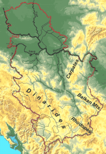
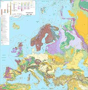
Serbia is in recent geologic time a part of the Eurasian Plate, but the bedrock lithologies are witness to a diverse geologic history.[1] In a tectonic sense, Serbia is part of an orogenic system that is composed of the Alpine, Carpathian, and Dinaride orogenic belts.[2][3] Its territory can be divided into five geotectonic units of differing genesis:[4][5]
- Pannonian Plain, occupying the northern part of the country (Vojvodina province)
- Dinaric Alps occupy western part of Central Serbia, stretching in general northwest-southeast direction
- Vardar Zone is a belt east of the Dinaric alps, continuing into central North Macedonia. It consists of three parts: Srem, Jadar and Kopaonik blocks, separated by ophiolitics fractures.
- Serbian-Macedonian Massif is a belt stretching in north-south direction along the Great and South Morava valleys, into western North Macedonia and northern Greece (north of Chalkidiki peninsula).
- Carpatho-Balkan Arc covers Eastern Serbia, in the shape of an arc. Its northern part, Serbian Carpathians is an extension of Carpathian Range, and it joins the western parts of Balkan Mountains, whose main massif is in Bulgaria.
Tectonic units
Sava Zone
The Sava Zone (named after the river Sava) is an oceanic suture that strikes roughly NNW to SSE through Serbia and is mostly covered in the north by the sediments of the Pannonian Basin. Outcrops can be found in the Fruška Gora (Fruška mountains).[2] Here the unit is composed of blueschists and ophiolites. In the south outcrops of the Sava Zone occur in the Balkan and Rhodope Mountains. This includes the Senonian Flysch and the rocks cropping out in the Jastrebac Window.[2]
Jadar-Kopaonik thrust sheet
The Jadar-Kopaonik Thrust Sheet is a NW-SE striking unit in the southern footwall of the Sava Zone and the northern hangingwall of the Drina-Ivanjica Thrust Sheet.[2] Most of the outcrops are ophiolites from the Western Vardar ocean, but there are some windows into the underlying basement. The Jadar unit in western Serbia (Jadar Region) is the largest window into the underlying Adriatic units of the Jadar-Kopaonik Thrust Sheet. Two smaller windows crop out farther to the south. The Studenica unit lies in the west and the Kopaonik unit in the east of the thrust sheet.[6]
Supragetic
The Supragetic nappes form a N-S striking belt in eastern Serbia, where they crop out in the Balkan Mountains (Stara Planina). They are part of the paleogeographic realm of Dacia. The Supragetic is subdivided into the Ranovac and Vlasina unit.[2]
Drina-Ivanjica thrust sheet
The Drina-Ivanjica thrust sheet forms a NNW to SSE striking thrust sheet through southwestern Serbia. It is composed of a Paleozoic basement and Mesozoic cover. On top of this lies the obducted Zlatibor ophiolite (Zlatibor Mountains), a remnant of the Western Vardar ocean.[2]
Seismic activity
Serbia is prone to moderate to strong seismic activity, especially in the central belts of Vardar Zone and Serbian Massif.[7] Major earthquakes in the 20th century ranged between 5.0 from 6.0 (Lazarevac 1922) Richter scale. The last major earthquake at 5.4 occurred near Kraljevo on 3 November 2010.[8]
List of major earthquakes in the 20th and 21st centuries:[9][10]
History of geologic investigation

The Serbian Geologic Society was established by a group of professors and students in Belgrade on 10 February 1891 under the leadership of Jovan Žujović.[11] The geologic survey was founded 29 December 1930.[12]
References
| Wikimedia Commons has media related to Geology of Serbia. |
- "Tectonic Plates: Divergent, Convergent, and Transform Boundaries" (PDF) (Map). Tectonics Observatory. California Institute of Technology. April 2009. Retrieved 19 September 2013.
- Schmid, Stefan M.; Daniel Bernoulli; Bernhard Fügenschuh; Liviu Matenco; Senecio Schefer; Ralf Schuster; Matthias Tischler; Kamil Ustaszewski (2008). "The Alpine-Carpathian-Dinaridic orogenic system: correlation and evolution of tectonic units" (PDF). Swiss Journal of Geosciences. 101 (1): 139–183. doi:10.1007/s00015-008-1247-3.
- Milena Zlokolica-Mandic. "Structural-Tectonic Elements as a Factor in Cave Development". Serbian Academy of Sciences and Arts. Archived from the original on 27 July 2011. Retrieved 3 November 2010.
- Mica Martinovic; Mihailo Milivojevic (25 April 2010). "Serbia Country Update" (PDF). Proceedings of World Geothermal Congress 2010. Archived from the original (PDF) on 22 July 2011.
- Eldridge M. Moores; Rhodes Whitmore Fairbridge (1997). Encyclopedia of European and Asian regional geology. Springer. pp. 786–789. ISBN 978-0-412-74040-4.
- Vasković, Nada; Vesna Matović (2010). Ophiolites of the Vardar Zone and the Dinarides:Central and West Serbia. ISBN 978-963-306-056-8.
- "Seismic Activity on the Territory Of Serbia --Overview Of Relevant Data" (PDF). First Workshop for the NATO Science For Peace Project. 7 November 2007. Archived from the original (PDF) on 28 July 2011.
- "Snažan zemljotres za ove prostore". B92. 3 November 2010.
- "Dve žrtve zemljotresa u Kraljevu". RTS. 11 March 2010.
- M. Marović; et al. (2002). "Neotectonics and seismicity of the southern margin of the Pannonian basin in Serbia". EGU Stephan Mueller Special Publication Series. 3: 277–295. doi:10.5194/smsps-3-277-2002.
- "Short History". Serbian Geologic Society. Retrieved 21 September 2013.
- "Istorijat Geološkog zavoda Srbije". Geoloski zavod Srbije. Retrieved 21 September 2013.