Furnace Creek, California
Furnace Creek is a census-designated place (CDP) in Inyo County, California. The population was 24 at the 2010 census, down from 31 at the 2000 census. The elevation of the village is 190 feet (58 m) below sea level. Furnace Creek holds the record for the highest reliably recorded air temperature on Earth at 134 °F (56.7 °C) on July 10, 1913, as well as the highest recorded natural ground surface temperature on Earth at 201 °F (93.9 °C) on July 15, 1972.
Furnace Creek | |
|---|---|
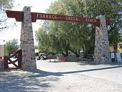 Entrance to Furnace Creek Ranch | |
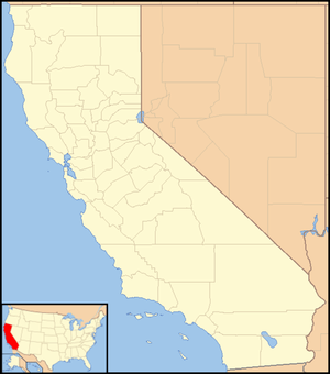 Furnace Creek Location in California | |
| Coordinates: 36°27′29″N 116°52′15″W | |
| Country | United States |
| State | California |
| County | Inyo |
| Area | |
| • Total | 31.463 sq mi (81.487 km2) |
| • Land | 31.203 sq mi (80.815 km2) |
| • Water | 0.260 sq mi (0.672 km2) 0.82% |
| Elevation | -190 ft (−60 m) |
| Population (2010) | |
| • Total | 24 |
| • Density | 0.76/sq mi (0.29/km2) |
| Time zone | UTC−08:00 (Pacific (PST)) |
| • Summer (DST) | UTC−07:00 (PDT) |
| ZIP Code | 92328 |
| Area codes | 442/760 |
| FIPS code | 06-28021 |
The visitor center, museum, and headquarters of the Death Valley National Park are located at Furnace Creek.[3]
Geography and climate
According to the United States Census Bureau, Furnace Creek has a total area of 31.5 square miles (82 km2), over 99% of it being land.
Springs in the Amargosa Range created a natural oasis at Furnace Creek, which has subsequently dwindled due to diversion of this water to support the village.[4]
From 1911 through 2006, Furnace Creek had an average high temperature of 91.4 °F (33.0 °C) and an average low temperature of 62.9 °F (17.2 °C). During that time period, the hottest month was July with an average daily high temperature of 116.5 °F (46.9 °C) and the driest month was June with an average monthly precipitation of 0.05 in (1.3 mm).[5]
Furnace Creek holds the record for the highest recorded temperature in the world, reaching 134 °F (56.7 °C) on July 10, 1913.[6] Some meteorologists dispute the accuracy of the 1913 temperature measurement.[7][8]
In addition, a ground temperature of 201 °F (93.9 °C) was recorded in Furnace Creek on July 15, 1972; this may be the highest natural ground surface temperature ever recorded.[9] (Temperatures measured directly on the ground may exceed air temperatures by 30 to 50 °C.[10])
| Climate data for Furnace Creek | |||||||||||||
|---|---|---|---|---|---|---|---|---|---|---|---|---|---|
| Month | Jan | Feb | Mar | Apr | May | Jun | Jul | Aug | Sep | Oct | Nov | Dec | Year |
| Record high °F (°C) | 88 (31) |
97 (36) |
102 (39) |
113 (45) |
122 (50) |
128 (53) |
134 (57) |
127 (53) |
123 (51) |
113 (45) |
98 (37) |
88 (31) |
134 (57) |
| Average high °F (°C) | 66.9 (19.4) |
73.3 (22.9) |
82.1 (27.8) |
90.5 (32.5) |
100.5 (38.1) |
109.9 (43.3) |
116.5 (46.9) |
114.7 (45.9) |
106.5 (41.4) |
92.8 (33.8) |
77.1 (25.1) |
65.2 (18.4) |
91.4 (33.0) |
| Daily mean °F (°C) | 53.4 (11.9) |
59.8 (15.4) |
68.4 (20.2) |
76.3 (24.6) |
86.6 (30.3) |
95.5 (35.3) |
102.2 (39.0) |
100.2 (37.9) |
91.0 (32.8) |
77.1 (25.1) |
62.6 (17.0) |
51.7 (10.9) |
77.2 (25.1) |
| Average low °F (°C) | 39.1 (3.9) |
46.3 (7.9) |
54.8 (12.7) |
62.1 (16.7) |
72.7 (22.6) |
81.2 (27.3) |
88 (31) |
85.7 (29.8) |
75.6 (24.2) |
61.5 (16.4) |
48.1 (8.9) |
38.3 (3.5) |
62.9 (17.2) |
| Record low °F (°C) | 14 (−10) |
26 (−3) |
26 (−3) |
39 (4) |
46 (8) |
54 (12) |
67 (19) |
65 (18) |
55 (13) |
37 (3) |
30 (−1) |
22 (−6) |
14 (−10) |
| Average precipitation inches (mm) | 0.39 (9.9) |
0.51 (13) |
0.30 (7.6) |
0.12 (3.0) |
0.03 (0.76) |
0.05 (1.3) |
0.07 (1.8) |
0.13 (3.3) |
0.21 (5.3) |
0.07 (1.8) |
0.18 (4.6) |
0.30 (7.6) |
2.36 (60) |
| Mean monthly sunshine hours | 217 | 226 | 279 | 330 | 372 | 390 | 403 | 372 | 330 | 310 | 210 | 186 | 3,625 |
| Source 1: NOAA 1981-2010 US Climate Normals [11] | |||||||||||||
| Source 2: http://weather2travel.com [12] | |||||||||||||
History

The William Tell Coleman Borax Company established Greenland Ranch in 1883, named after the green alfalfa fields which they planted there. They established a weather station at the ranch in 1891. Greenland Ranch was renamed Furnace Creek Ranch in 1933.[13]
The Timbisha tribe currently live at the Death Valley Indian Community reservation here.[14] They provided many of the artisans and builders to construct the original Fred Harvey Company resort buildings, the Indian Village, and Park Service structures. They compose the majority of residents of Furnace Creek's permanent population at the tribe's reservation.[15] Furnace Creek was formerly the center of Death Valley mining and operations for the Pacific Coast Borax Company and the historic 20 Mule Teams hauling wagon trains of borax across the Mojave Desert.[16]
On the afternoon of July 10, 1913, a temperature of 134 °F (56.7 °C) was recorded at Greenland Ranch.[17] This temperature stands as the highest ambient air temperature ever recorded at the surface of the Earth.[18]
Demographics
| Historical population | |||
|---|---|---|---|
| Census | Pop. | %± | |
| U.S. Decennial Census[19] | |||
The 2010 United States Census[20] reported that Furnace Creek had a population of 24. The population density was 0.8 people per square mile (0.3/km²). The racial makeup was six (25.0%) White, 16 (66.7%) American Indian, and two (8.3%) from two or more races.
The Census reported that 24 people (100% of the population) lived in households. There were 15 households, out of which two (13.3%) had children under age 18, four (26.7%) were married couples living together, four (20.0%) had a female householder with no husband present. Eight households (53.3%) were made up of individuals and three (20.0%) had someone living alone who was 65 or older. The average household size was 1.60. There were seven families (46.7%), and the average family size was 2.29. The population consisted of two people (8.3%) under 18, two (8.3%) aged 18 to 24, five (20.8%) aged 25 to 44, nine (37.5%) aged 45 to 64, and six (25.0%) who were 65 or older. The median age was 52.0 years.
There were 15 occupied housing units at an average density of 0.6 per square mile (0.2/km²), of which 11 (73.3%) were owner-occupied, and four (26.7%) were occupied by renters.[21]
Politics
In the state legislature, Furnace Creek is in the 8th Senate District, represented by Republican Andreas Borgeas,[22] and the 26th Assembly District, represented by Republican Devon Mathis.[23]
Federally, Furnace Creek is in California's 8th congressional district, represented by Republican Paul Cook.[24]
Tourist facilities
The village is surrounded by a number of National Park Service public campgrounds. The Ranch at Death Valley is located here, part of the Oasis at Death Valley, one of the park's major tourist facilities. The Furnace Creek Golf Course attached to the ranch claims to be the lowest in the world at 214 feet (65 m) below sea level. Some of the lodging is closed in the summer when temperatures can exceed 125 °F (52 °C), but the golf course remains open; the resort established a summer tournament in 2011 called the Heatstroke Open which drew a field of 48.[25] There are also a restaurant, cafe, store, and gas station in Furnace Creek village. The Furnace Creek Airport is located about 0.75 miles (1.21 km) west of the park headquarters.
References
- "2010 Census U.S. Gazetteer Files – Places – California". United States Census Bureau.
- U.S. Geological Survey Geographic Names Information System: Furnace Creek, California
- NPS- Death Valley Visitor Center (accessed 4/11/2010.
- "Furnace Creek: Focus on Water". US Geological Survey report. Archived from the original on 2009-11-20. Retrieved 2010-02-23.
- The average annual temperature is 77.2 °F (25.1 °C)."Weather and Climate - Death Valley National Park" (PDF). National Park Service. Retrieved 2014-02-04.
- El Fadli, Khalid Ibrahim; et al. (September 2012). "World Meteorological Organization Assessment of the Purported World Record 58°C Temperature Extreme at El Azizia, Libya (13 September 1922)". Bulletin of the American Meteorological Society. 94 (2): 199–204. Bibcode:2013BAMS...94..199E. doi:10.1175/BAMS-D-12-00093.1.
- Masters, Jeff. "Historic Heat Wave Reponsible(sic) for Death Valley's 129°F Gradually Weakening". WunderBlog. Wunderground.
- Burt, Christopher. "An Investigation of Death Valley's 134°F World Temperature Record". WunderBlog. Wunderground.
- A possible world record maximum natural ground surface temperature, Paul Kubecka, Weather, 56, #7 (July 2001), Weather, pp. 218-221, doi:10.1002/j.1477-8696.2001.tb06577.x.
- Mildrexler, David J.; Zhao, Maosheng; Running, Steven W. (2011). "Satellite Finds Highest Land Skin Temperatures on Earth". Bulletin of the American Meteorological Society. 92 (7): 855–860. Bibcode:2011BAMS...92..855M. doi:10.1175/2011BAMS3067.1.
- NOAA. "1981-2010 US Climate Normals". NOAA. Retrieved 2011-07-25.
- Weather2travel.com. "Weather2travel Death Valley Climate". Retrieved 2011-06-16.
- "Furnace Creek Resort". Archived from the original on 2013-05-13. Retrieved 2012-06-14.
- Timbisha Shoshone Tribe History (accessed 4/10/2010)
- The Timbisha Shoshone Tribe, Death Valley (accessed 4/10/2010)
- NPS- Death Valley History (accessed 4/11/2010)
- "World Meteorological Organization World Weather / Climate Extremes Archive". Archived from the original on 4 January 2013. Retrieved 10 January 2013.
- El Fadli, KI; et al. (September 2012). "World Meteorological Organization Assessment of the Purported World Record 58°C Temperature Extreme at El Azizia, Libya (13 September 1922)". Bulletin of the American Meteorological Society. 94 (2): 199. Bibcode:2013BAMS...94..199E. doi:10.1175/BAMS-D-12-00093.1.
- "Census of Population and Housing". Census.gov. Retrieved June 4, 2016.
- "2010 Census Interactive Population Search: CA - Furnace Creek CDP". U.S. Census Bureau. Archived from the original on December 25, 2016. Retrieved July 12, 2014.
- "Furnace Creek CDP, California". 2010 Census. U.S. Census Bureau. Archived from the original on 2020-02-13. Retrieved 2018-09-30.
- "Senators". State of California. Retrieved April 11, 2013.
- "Members Assembly". State of California. Retrieved April 11, 2013.
- "California's 8th Congressional District - Representatives & District Map". Civic Impulse, LLC. Retrieved April 11, 2013.
- Yoon, Peter (August 17, 2011). "This is what 18 in hell feels like". ESPNLosAngeles.com. Retrieved August 17, 2011.
External links
| Wikimedia Commons has media related to Furnace Creek. |
- Official Death Valley National Park website
- Official Timbisha Shoshone Tribe website
- Furnace Creek interactive map of local points of interest
| Authority control |
|
|---|