Cartago, California
Cartago (formerly Carthage, Daniersburg, and Lakeville) is a census-designated place in Inyo County, California, United States.[2] Cartago is located on the west side of Owens Lake 3 miles (4.8 km) north-northwest of Olancha,[3] at an elevation of 3629 feet (1106 m).[2] The population was 92 at the 2010 census, down from 109 at the 2000 census.
Cartago | |
|---|---|
 Cartago | |
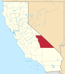
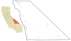 Location in Inyo County and the state of California | |
 Cartago Location in the United States | |
| Coordinates: 36°19′15″N 118°01′35″W | |
| Country | |
| State | |
| County | Inyo |
| Area | |
| • Total | 1.172 sq mi (3.036 km2) |
| • Land | 1.169 sq mi (3.029 km2) |
| • Water | 0.003 sq mi (0.007 km2) 0.24% |
| Elevation | 3,629 ft (1,106 m) |
| Population (2010) | |
| • Total | 92 |
| • Density | 78/sq mi (30/km2) |
| Time zone | UTC-8 (Pacific (PST)) |
| • Summer (DST) | UTC-7 (PDT) |
| ZIP code | 93549 |
| Area codes | 442/760 |
| FIPS code | 06-11600 |
| GNIS feature ID | 1660442 |
Geography
According to the United States Census Bureau, the CDP has a total area of 1.2 square miles (3.1 km2), over 99% of it land.
History
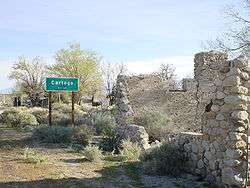
Located near the now abandoned settlement of Carthage, Cartago took its name from the Spanish name for ancient Carthage.[3] The first post office at Cartago opened in 1918.[3] During the heyday of mining in the area (the 1870s), Cartago was a steamboat port for shipment of wood and ore.[3]
Demographics
| Historical population | |||
|---|---|---|---|
| Census | Pop. | %± | |
| U.S. Decennial Census[4] | |||
2010
At the 2010 census Cartago had a population of 92. The population density was 78.5 people per square mile (30.3/km²). The racial makeup of Cartago was 63 (68.5%) White, 0 (0.0%) African American, 7 (7.6%) Native American, 0 (0.0%) Asian, 0 (0.0%) Pacific Islander, 11 (12.0%) from other races, and 11 (12.0%) from two or more races. Hispanic or Latino of any race were 16 people (17.4%).[5]
The whole population lived in households, no one lived in non-institutionalized group quarters and no one was institutionalized.
There were 44 households, 11 (25.0%) had children under the age of 18 living in them, 18 (40.9%) were opposite-sex married couples living together, 5 (11.4%) had a female householder with no husband present, 2 (4.5%) had a male householder with no wife present. There were 1 (2.3%) unmarried opposite-sex partnership, and 0 (0%) same-sex married couples or partnerships. 18 households (40.9%) were one person and 4 (9.1%) had someone living alone who was 65 or older. The average household size was 2.09. There were 25 families (56.8% of households); the average family size was 2.88.
The age distribution was 19 people (20.7%) under the age of 18, 9 people (9.8%) aged 18 to 24, 18 people (19.6%) aged 25 to 44, 30 people (32.6%) aged 45 to 64, and 16 people (17.4%) who were 65 or older. The median age was 45.0 years. For every 100 females, there were 124.4 males. For every 100 females age 18 and over, there were 135.5 males.
There were 55 housing units at an average density of 46.9 per square mile (18.1/km²),of which 44 were occupied, 28 (63.6%) by the owners and 16 (36.4%) by renters. The homeowner vacancy rate was 0%; the rental vacancy rate was 0%. 58 people (63.0% of the population) lived in owner-occupied housing units and 34 people (37.0%) lived in rental housing units.
2000
At the 2000 census there were 109 people, 40 households, and 25 families in the CDP. The population density was 68.7 people per square mile (26.5/km²). There were 49 housing units at an average density of 30.9 per square mile (11.9/km²). The racial makeup of the CDP was 76.15% White, 2.75% Native American, 20.18% from other races, and 0.92% from two or more races. 38.53% of the population were Hispanic or Latino of any race.[6] Of the 40 households 37.5% had children under the age of 18 living with them, 40.0% were married couples living together, 15.0% had a female householder with no husband present, and 37.5% were non-families. 32.5% of households were one person and 12.5% were one person aged 65 or older. The average household size was 2.73 and the average family size was 3.36.
The age distribution was 31.2% under the age of 18, 9.2% from 18 to 24, 27.5% from 25 to 44, 19.3% from 45 to 64, and 12.8% 65 or older. The median age was 28 years. For every 100 females, there were 142.2 males. For every 100 females age 18 and over, there were 127.3 males.
The median household income was $34,375 and the median family income was $50,625. Males had a median income of $33,750 versus $7,083 for females. The per capita income for the CDP was $14,699. There were no families and 5.1% of the population living below the poverty line, including no under eighteens and 27.3% of those over 64.
Politics
In the state legislature, Cartago is in the 8th Senate District, represented by Republican Andreas Borgeas,[7] and the 26th Assembly District, represented by Republican Devon Mathis.[8]
Federally, Cartago is in California's 8th congressional district, represented by Republican Paul Cook.[9]
References
- "2010 Census U.S. Gazetteer Files – Places – California". United States Census Bureau.
- U.S. Geological Survey Geographic Names Information System: Cartago, California
- Durham, David L. (1998). California's Geographic Names: A Gazetteer of Historic and Modern Names of the State. Clovis, Calif.: Word Dancer Press. p. 1152. ISBN 1-884995-14-4.
- "Census of Population and Housing". Census.gov. Retrieved June 4, 2016.
- "2010 Census Interactive Population Search: CA - Cartago CDP". U.S. Census Bureau. Archived from the original on July 15, 2014. Retrieved July 12, 2014.
- "U.S. Census website". United States Census Bureau. Retrieved 2008-01-31.
- "Senators". State of California. Retrieved April 11, 2013.
- "Members Assembly". State of California. Retrieved April 11, 2013.
- "California's 8th Congressional District - Representatives & District Map". Civic Impulse, LLC. Retrieved April 11, 2013.