Wilkerson, California
Wilkerson is a census-designated place (CDP) in Inyo County, California, United States. The population was 563 at the 2010 census, up from 562 at the 2000 census.
Wilkerson | |
|---|---|
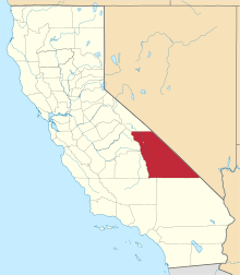
 Location in Inyo County and the state of California | |
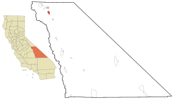
 Wilkerson Location in the United States | |
| Coordinates: 37°16′46″N 118°23′16″W | |
| Country | |
| State | |
| County | Inyo |
| Area | |
| • Total | 5.728 sq mi (14.835 km2) |
| • Land | 5.727 sq mi (14.833 km2) |
| • Water | 0.001 sq mi (0.002 km2) 0.013% |
| Population (2010) | |
| • Total | 563 |
| • Density | 98/sq mi (38/km2) |
| Time zone | UTC-8 (Pacific (PST)) |
| • Summer (DST) | UTC-7 (PDT) |
| ZIP code | 93514 |
| Area codes | 442/760 |
| FIPS code | 06-85551 |
| GNIS feature ID | 2409595 |
| U.S. Geological Survey Geographic Names Information System: Wilkerson, California | |
Geography
Wilkerson is located at 37°16′46″N 118°23′16″W.[2]
According to the United States Census Bureau, the CDP has a total area of 5.7 square miles (15 km2), over 99% of it land.
Demographics
2010
At the 2010 census Wilkerson had a population of 563. The population density was 98.3 people per square mile (38.0/km²). The racial makeup of Wilkerson was 524 (93.1%) White, 0 (0.0%) African American, 13 (2.3%) Native American, 5 (0.9%) Asian, 1 (0.2%) Pacific Islander, 5 (0.9%) from other races, and 15 (2.7%) from two or more races. Hispanic or Latino of any race were 53 people (9.4%).[3]
The whole population lived in households, no one lived in non-institutionalized group quarters and no one was institutionalized.
There were 244 households, 55 (22.5%) had children under the age of 18 living in them, 151 (61.9%) were opposite-sex married couples living together, 14 (5.7%) had a female householder with no husband present, 8 (3.3%) had a male householder with no wife present. There were 10 (4.1%) unmarried opposite-sex partnerships, and 1 (0.4%) same-sex married couples or partnerships. 65 households (26.6%) were one person and 31 (12.7%) had someone living alone who was 65 or older. The average household size was 2.31. There were 173 families (70.9% of households); the average family size was 2.76.
The age distribution was 100 people (17.8%) under the age of 18, 22 people (3.9%) aged 18 to 24, 88 people (15.6%) aged 25 to 44, 238 people (42.3%) aged 45 to 64, and 115 people (20.4%) who were 65 or older. The median age was 51.2 years. For every 100 females, there were 101.1 males. For every 100 females age 18 and over, there were 97.9 males.
There were 265 housing units at an average density of 46.3 per square mile (17.9/km²),of which 244 were occupied, 200 (82.0%) by the owners and 44 (18.0%) by renters. The homeowner vacancy rate was 1.5%; the rental vacancy rate was 4.3%. 466 people (82.8% of the population) lived in owner-occupied housing units and 97 people (17.2%) lived in rental housing units.
2000
At the 2000 census there were 562 people, 234 households, and 160 families in the CDP. The population density was 98.0 people per square mile (37.9/km²). There were 245 housing units at an average density of 42.7 per square mile (16.5/km²). The racial makeup of the CDP was 94.66% White, 0.18% Native American, 0.71% Asian, 1.07% from other races, and 3.38% from two or more races. 5.16% of the population were Hispanic or Latino of any race.[4] Of the 234 households 27.8% had children under the age of 18 living with them, 56.8% were married couples living together, 4.7% had a female householder with no husband present, and 31.2% were non-families. 27.4% of households were one person and 13.2% were one person aged 65 or older. The average household size was 2.40 and the average family size was 2.89.
The age distribution was 23.3% under the age of 18, 5.9% from 18 to 24, 21.2% from 25 to 44, 32.6% from 45 to 64, and 17.1% 65 or older. The median age was 45 years. For every 100 females, there were 105.1 males. For every 100 females age 18 and over, there were 100.5 males.
The median household income was $35,583 and the median family income was $55,625. Males had a median income of $39,750 versus $22,981 for females. The per capita income for the CDP was $20,182. None of the families and 4.6% of the population were living below the poverty line, including no under eighteens and 3.1% of those over 64.
Politics
In the state legislature, Wilkerson is in the 8th Senate District, represented by Republican Andreas Borgeas,[5] and the 26th Assembly District, represented by Republican Devon Mathis.[6]
Federally, Wilkerson is in California's 8th congressional district, represented by Republican Paul Cook.[7]
References
- "2010 Census U.S. Gazetteer Files – Places – California". United States Census Bureau.
- U.S. Geological Survey Geographic Names Information System: Wilkerson, California
- "2010 Census Interactive Population Search: CA - Wilkerson CDP". U.S. Census Bureau. Archived from the original on July 15, 2014. Retrieved July 12, 2014.
- "U.S. Census website". United States Census Bureau. Retrieved 2008-01-31.
- "Senators". State of California. Retrieved April 11, 2013.
- "Members Assembly". State of California. Retrieved April 11, 2013.
- "California's 8th Congressional District - Representatives & District Map". Civic Impulse, LLC. Retrieved April 11, 2013.