Flatlands, Brooklyn
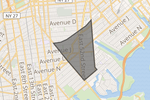
Flatlands is a neighborhood in the southeast part of the borough of Brooklyn in New York City. The current neighborhood borders are roughly defined by the Bay Ridge Branch to the north, Avenue U to the south, Ralph Avenue to the east, and Flatbush Avenue to the southwest.
Flatlands | |
|---|---|
Neighborhood of Brooklyn | |
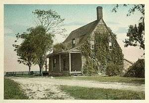 Jans Martense Schenck house, Flatlands, built 1675, formerly at Avenue U and East 63rd Street | |
Location in New York City | |
| Coordinates: 40.621°N 73.935°W | |
| Country | |
| State | |
| City | |
| Borough | |
| Community District | Brooklyn 18[1] |
| Area | |
| • Total | 2.2800 sq mi (5.9053 km2) |
| Population | |
| • Total | 64,762 |
| • Density | 28,000/sq mi (11,000/km2) |
| Ethnicity | |
| • Black | 66.3% |
| • White | 18.2 |
| • Hispanic | 8.9 |
| • Asian | 4.0 |
| • Other | 2.6 |
| Time zone | UTC−5 (Eastern) |
| • Summer (DST) | UTC−4 (EDT) |
| ZIP Code | 11234 |
| Area codes | 718, 347, 929, and 917 |
| New Netherland series |
|---|
| Exploration |
| Fortifications: |
|
| Settlements: |
| The Patroon System |
|
| People of New Netherland |
| Flushing Remonstrance |
 |
Originally an independent town,[4][5] Flatlands became part of the City of Brooklyn in 1896.[6]
Flatlands is part of Brooklyn Community District 18 and its primary ZIP Code is 11234.[1] It is patrolled by the 63rd Precinct of the New York City Police Department.[7] Politically it is represented by the New York City Council's 45th and 46th Districts.[8]
History
Flatlands was originally known as Nieuw Amersfoort, after the Dutch city of Amersfoort, and was established as a farming community in 1636 when Wolfert Gerritse Van Couwenhoven and Andries Hudde purchased 15,000 acres of land centered on what is now the intersection of Kings Highway and Flatbush Avenue.[4]
Though the area was purchased from Lenape Native Americans,[9] there is no definitive evidence that the area was actually inhabited by them, as the notion of land ownership in Lenape culture differed substantially from that of Europeans and they may have been a transient population.
Flatlands was given the right to local rule in 1661 by Peter Stuyvesant as one of the five Dutch Towns on Long Island.
The town’s growth and development came late, largely due to the lack of a transit system or set of roads connecting it with other parts of Brooklyn. Flatlands was annexed by the city of Brooklyn in 1896. At the time, it contained numerous small islands on Jamaica Bay, including Mill Island, Bergen Island, and Barren Island.[6]
Land use
Crops typically grown in the area were beans, corn, marsh hay, squash, potato bean and tobacco. Oysters and clams were also farmed and harvested from Jamaica Bay, surrounding marshes and basins. The land-controlling families of Nieuw Amersfoort also kept black slaves to work their farms until the state declared emancipation of all slaves in 1827, after which black laborers took up farming jobs, many times on the farms they worked on as slaves.[10]
Historic buildings

Historic homes dated to the 18th century include the Stoothoff-Baxter-Kouwenhaven House and Joost Van Nuyse House.[11]
Other historic structures are the Hendrick I. Lott House (East 36th Street between Fillmore Ave and Ave. S, built around 1720), which was a stop on the Underground Railroad, and the Flatlands Dutch Reformed Church, founded by Pieter Clausen Wycoff.
Demographics
Based on data from the 2010 United States Census, the population of Flatlands was 64,762, a decrease of 1,964 (2.9%) from the 66,726 counted in 2000. Covering an area of 1,249.32 acres (505.58 ha), the neighborhood had a population density of 51.8 inhabitants per acre (33,200/sq mi; 12,800/km2).[2]
The racial makeup of the neighborhood was 18.2% (11,793) White, 66.3% (42,935) African American, 0.2% (158) Native American, 4.0% (2,577) Asian, 0.0% (16) Pacific Islander, 0.5% (334) from other races, and 1.8% (1,196) from two or more races. Hispanic or Latino of any race were 8.9% (5,753) of the population.[3]
The entirety of Community Board 18, which comprises Canarsie and Flatlands, had 165,543 inhabitants as of NYC Health's 2018 Community Health Profile, with an average life expectancy of 82.0 years.[12]:2, 20 This is slightly higher than the median life expectancy of 81.2 for all New York City neighborhoods.[13]:53 (PDF p. 84)[14] Most inhabitants are middle-aged adults and youth: 25% are between the ages of 0–17, 29% between 25–44, and 24% between 45–64. The ratio of college-aged and elderly residents was lower, at 9% and 13% respectively.[12]:2
As of 2016, the median household income in Community Board 18 was $76,647.[15] In 2018, an estimated 15% of Canarsie and Flatlands residents lived in poverty, compared to 21% in all of Brooklyn and 20% in all of New York City. One in eleven residents (9%) were unemployed, compared to 9% in the rest of both Brooklyn and New York City. Rent burden, or the percentage of residents who have difficulty paying their rent, is 50% in Canarsie and Flatlands, lower than the citywide and boroughwide rates of 52% and 51% respectively. Based on this calculation, as of 2018, Canarsie and Flatlands are considered to be high-income relative to the rest of the city and not gentrifying.[12]:7
Shopping district
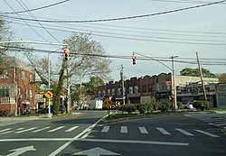
The main shopping streets in Flatlands are Utica Avenue, Flatbush Avenue, Avenue N, and Ralph Avenue. Residents also commonly shop at the nearby indoor mall, Kings Plaza, located at the border of Flatlands and Marine Park, while being across the water from the neighborhood of Mill Basin.
Police and crime
Flatlands is patrolled by the New York City Police Department's 63rd Precinct. The precinct also covers Marine Park, Mill Basin, and Bergen Beach.[7] The 63rd Precinct ranked 31st safest out of 69 patrol areas for per-capita crime in 2010.[16] With a non-fatal assault rate of 46 per 100,000 people, Canarsie and Flatlands's rate of violent crimes per capita is less than that of the city as a whole. The incarceration rate of 380 per 100,000 people is lower than that of the city as a whole.[12]:8
The 63rd Precinct has a lower crime rate than in the 1990s, with crimes across all categories having decreased by 85.9% between 1990 and 2018. The precinct reported 5 murders, 14 rapes, 88 robberies, 131 felony assaults, 92 burglaries, 495 grand larcenies, and 62 grand larcenies auto in 2018.[17]
Fire safety
The New York City Fire Department (FDNY)'s Engine Co. 309/Ladder Co. 159 is located at 1851 East 48th Street.[18][19]
Health
Preterm births are more common in Canarsie and Flatlands than in other places citywide, though teenage births are less common. In Canarsie and Flatlands, there were 89 preterm births per 1,000 live births (compared to 87 per 1,000 citywide), and 11.6 teenage births per 1,000 live births (compared to 19.3 per 1,000 citywide).[12]:11 Canarsie and Flatlands has a relatively low population of residents who are uninsured, or who receive healthcare through Medicaid.[20] In 2018, this population of uninsured residents was estimated to be 21%, which is higher than the citywide rate of 12%.[12]:14
The concentration of fine particulate matter, the deadliest type of air pollutant, in Canarsie and Flatlands is 0.0071 milligrams per cubic metre (7.1×10⁻⁹ oz/cu ft), lower than the citywide and boroughwide averages.[12]:9 Fifteen percent of Canarsie and Flatlands residents are smokers, which is slightly higher than the city average of 14% of residents being smokers.[12]:13 In Canarsie and Flatlands, 30% of residents are obese, 14% are diabetic, and 37% have high blood pressure—compared to the citywide averages of 24%, 11%, and 28% respectively.[12]:16 In addition, 21% of children are obese, compared to the citywide average of 20%.[12]:12
Eighty-one percent of residents eat some fruits and vegetables every day, which is lower than the city's average of 87%. In 2018, 77% of residents described their health as "good," "very good," or "excellent," slightly less than the city's average of 78%.[12]:13 For every supermarket in Canarsie and Flatlands, there are 9 bodegas.[12]:10
Post offices and ZIP Code
Flatlands is covered by ZIP Code 11234.[21] The United States Post Office's Canarsie Station is located at 10201 Flatlands Avenue,[22] while the Ryder Station is located at 1739 East 45th Street.[23]
Education

Canarsie and Flatlands generally has a similar ratio of college-educated residents to the rest of the city. Though 40% of residents age 25 and older have a college education or higher, 13% have less than a high school education and 48% are high school graduates or have some college education. By contrast, 40% of Brooklynites and 38% of city residents have a college education or higher.[12]:6 The percentage of Canarsie and Flatlands students excelling in math rose from 40 percent in 2000 to 57 percent in 2011, though reading achievement decreased from 48% to 46% during the same time period.[24]
Canarsie and Flatlands's rate of elementary school student absenteeism is slightly lower than the rest of New York City. In Canarsie and Flatlands, 17% of elementary school students missed twenty or more days per school year, compared to the citywide average of 20% of students.[24]:24 (PDF p. 55)[12]:6 Additionally, 80% of high school students in Canarsie and Flatlands graduate on time, equal to the citywide average of 75% of students.[12]:6
Schools
Flatlands contains the following public elementary schools which serve grades PK-5 unless otherwise indicated:[25]
The following schools are located nearby:[25]
- PS 207 Elizabeth G Leary (grades PK-8), in Marine Park[30]
- PS 222 Katherine R Snyder (grades PK-5), in Marine Park[31]
- PS 236 Mill Basin (grades PK-5), in Mill Basin[32]
- PS 312 Bergen Beach (grades PK-5), in Bergen Beach[33]
- JHS 78 Roy H Mann (grades 6-8), in Bergen Beach[34]
- Brooklyn Theatre Arts High School (grades 9-12), in Canarsie
Libraries

The Brooklyn Public Library (BPL) has two branches in Flatlands. The Flatlands branch is located at 2065 Flatbush Avenue near Avenue P. It was opened in a former Prudential Savings Bank branch in 1949, and moved to its current 6,000-square-foot (560 m2) space in 1955.[35]
The Paerdegat branch is located at 850 East 59th Street near Paerdegat Avenue South. It opened in 1950 and moved to its current building in 1959.[36]
Transportation
No New York City Subway service runs into Flatlands. However, many residents live within walking distance of the IRT Nostrand Avenue Line (2 and 5 trains) which terminates at the junction of Flatbush and Nostrand Avenues; others use buses to get to the BMT Brighton Line (B and Q trains) or the BMT Canarsie Line (L train). Local and express buses are also used as a means of travel in and around the area. As of August 2019, the buses that serve Flatlands are the B2, B3, B6, B7, B9, B41, B44, B44 SBS, B46, B46 SBS, B47, B82, B82 SBS, B100, B103, BM1, BM2 and Q35.[37]
Notable residents
- Neil Bogart (1943-1982), founder of Casablanca Records, was raised in the Glenwood Houses project in Flatlands[38]
- Roy DeMeo (1942-1983), Gambino crime family member[39]
- Leonard DiMaria (born 1941), mobster and Caporegime in the Gambino crime family[40]
- Abner Louima (born 1966), Haitian immigrant and father, brutally assaulted by NYPD
- Chris Mullin (born 1963), former NBA basketball player, was born and raised in Flatlands.[41]
- Steven Van Voorhees (1600-1684), magistrate, first Voorhees in America
- Wolfert Gerritse Van Couwenhoven (1579-1662), New Netherland colonist and the original patentee.
References
Notes
- "NYC Planning | Community Profiles". communityprofiles.planning.nyc.gov. New York City Department of City Planning. Retrieved April 7, 2018.
- Table PL-P5 NTA: Total Population and Persons Per Acre - New York City Neighborhood Tabulation Areas*, 2010, Population Division - New York City Department of City Planning, February 2012. Accessed June 14, 2016.
- Table PL-P3A NTA: Total Population by Mutually Exclusive Race and Hispanic Origin - New York City Neighborhood Tabulation Areas*, 2010, Population Division - New York City Department of City Planning, March 29, 2011. Accessed June 14, 2016.
- 1832-1909., Stiles, Henry Reed (c. 2009). A history of the city of Brooklyn : including the old towns of Brooklyn, Bushwick, and Williamsburgh. Carlisle, Mass.: Applewood Books. ISBN 978-1429022224. OCLC 502030985.CS1 maint: numeric names: authors list (link)
- "Narrows-Jamaica Bay, Brooklyn. - David Rumsey Historical Map Collection".
- Manbeck, John B. (2008), Brooklyn: Historically Speaking, Charleston, South Carolina: The History Press, ISBN 978-1-59629-500-1, p.79
- "NYPD – 63rd Precinct". www.nyc.gov. New York City Police Department. Retrieved October 3, 2016.
- Current City Council Districts for Kings County, New York City. Accessed May 5, 2017.
- Kilgannon, Corey (November 1, 2007). "Dutch Deed Fetches More Than a Handful of Beads". City Room. Retrieved May 16, 2018.
- "Flatlands Historic Hubbards Lane".
- "National Register Information System". National Register of Historic Places. National Park Service. March 13, 2009.
- "Flatlands and Canarsie (Including Bergen Beach, Canarsie, Flatlands, Georgetown, Marine Park and Mill Basin)" (PDF). nyc.gov. NYC Health. 2018. Retrieved March 2, 2019.
- "2016-2018 Community Health Assessment and Community Health Improvement Plan: Take Care New York 2020" (PDF). nyc.gov. New York City Department of Health and Mental Hygiene. 2016. Retrieved September 8, 2017.
- "New Yorkers are living longer, happier and healthier lives". New York Post. June 4, 2017. Retrieved March 1, 2019.
- "NYC-Brooklyn Community District 18--Canarsie & Flatlands PUMA, NY". Census Reporter. Retrieved July 17, 2018.
- "Flatlands – DNAinfo.com Crime and Safety Report". www.dnainfo.com. Archived from the original on April 15, 2017. Retrieved October 6, 2016.
- "63rd Precinct CompStat Report" (PDF). www.nyc.gov. New York City Police Department. Retrieved July 22, 2018.
- "Engine Company 309/Ladder Company 159". FDNYtrucks.com. Retrieved March 2, 2019.
- "FDNY Firehouse Listing – Location of Firehouses and companies". NYC Open Data; Socrata. New York City Fire Department. September 10, 2018. Retrieved March 14, 2019.
- New York City Health Provider Partnership Brooklyn Community Needs Assessment: Final Report, New York Academy of Medicine (October 3, 2014).
- "NYC Neighborhood ZIP Code Definitions". New York State Department of Health. November 7, 2014. Retrieved March 5, 2019.
- "Location Details: Canarsie". USPS.com. Retrieved June 20, 2018.
- "Location Details: Ryder". USPS.com. Retrieved March 7, 2019.
- "Flatlands/Canarsie – BK 18" (PDF). Furman Center for Real Estate and Urban Policy. 2011. Retrieved October 5, 2016.
- Zillow. "Flatlands New York School Ratings and Reviews". Zillow. Retrieved March 4, 2019.
- "P.S. 119 Amersfort". New York City Department of Education. December 19, 2018. Retrieved March 7, 2019.
- "P.S. 203 Floyd Bennett School". New York City Department of Education. December 19, 2018. Retrieved March 7, 2019.
- "P.S. 251 Paerdegat". New York City Department of Education. December 19, 2018. Retrieved March 7, 2019.
- "P.S. 326". New York City Department of Education. December 19, 2018. Retrieved March 7, 2019.
- "P.S. 207 Elizabeth G. Leary". New York City Department of Education. December 19, 2018. Retrieved March 7, 2019.
- "P.S. 222 Katherine R. Snyder". New York City Department of Education. December 19, 2018. Retrieved March 7, 2019.
- "P.S. 236 Mill Basin". New York City Department of Education. December 19, 2018. Retrieved March 7, 2019.
- "P.S. 312 Bergen Beach". New York City Department of Education. December 19, 2018. Retrieved March 7, 2019.
- "J.H.S. 078 Roy H. Mann". New York City Department of Education. December 19, 2018. Retrieved March 7, 2019.
- "Flatlands Library". Brooklyn Public Library. August 19, 2011. Retrieved February 21, 2019.
- "Paerdegat Library". Brooklyn Public Library. August 22, 2011. Retrieved February 21, 2019.
- "Brooklyn Bus Map" (PDF). Metropolitan Transportation Authority. November 2017. Retrieved April 24, 2018.
- Contrera, Al. Hushabye: The Mystics, the Music, and the Mob, p. 263. Balboa Press, 2018. ISBN 9781982200282. Accessed August 13, 2019. "Bogart (Neil Scott Bogatz) was born in the same neighborhood as Joe, Bruce and Eddie, and there was this connection that occurs whenever you meet a fellow Brooklynite. He grew up in the Glenwood housing projects in the Flatlands section of Brooklyn, the same area as Joe, Eddie and Bruce."
- Kennedy, David. The Men of Honor, p. 143. Accessed August 13, 2019. Diamondback Publishers International, 2018. ISBN 9781386305439. "But the Brooklyn faction had a crew that was even more violent, some were certifiable psychopaths, led by capo Roy DeMeo. Working out of the Flatlands section of Brooklyn, DeMeo, who was a trained butcher by trade, had taught his young proteges how to kill cleanly and efficiently."
- Raab, Selwyn. "Reputed New Gambino Boss Is Arrested", The New York Times, December 19, 1996. Accessed August 13, 2019. "Another major defendant in the case is Leonard DiMaria, 55, who officials say is Mr. Corozzo's right-hand capo who recently took command of Mr. Corozzo's old Brooklyn crew. Mr. DiMaria was arrested by the F.B.I. at his home in Flatlands, Brooklyn."
- Anderson, Dave. "Sports Of The Times; The Mullins Live A Family Fantasy", The New York Times, March 16, 1985. Accessed August 13, 2019. "It's known as basketball, but it's really rimball. That's what the players shoot at - a rim, not a basket. Chris Mullin learned to shoot by aiming at the rim on the garage in the driveway of his Brooklyn home.... A rim is a rim is a rim - 18 inches in diameter. But the battered old rim on the Mullin garage is now a shrine in the Flatlands neighborhood."
Further reading
- New York Times article on Flatlands
- History of Flatlands including early Dutch settlers
- Manbeck, John B. and Jackson, Kenneth T. The Neighborhoods of Brooklyn. New Haven: Yale University Press, 2004. ISBN 0-300-07752-1
- New York City Landmarks Preservation Commission; Dolkart, Andrew S.; Postal, Matthew A. (2009). Postal, Matthew A. (ed.). Guide to New York City Landmarks (4th ed.). New York: John Wiley & Sons. ISBN 978-0-470-28963-1.
External links