Southfield, Staten Island
Southfield was a Town in Richmond County, New York. It was located in the southeastern part of Staten Island, along Lower New York Bay prior to the incorporation of Staten Island into New York City in 1898, bounded on the west roughly by Richmond Road, Giffords Lane, Amboy Road, and Arden Avenue.[1]
The town's origins dates to an administrative division of the island made by English colonists in the late 17th century, after they took over New Netherland from the Dutch in 1664. The town was incorporated as one of the four original divisions of Richmond County in 1788.[2] In 1860, Middletown was created from parts of Southfield and Castleton.[3][4] Fort Wadsworth is located in Southfield.
The town was dissolved in 1898 upon consolidation into the City of New York.
The present-day neighborhoods in the former town include:
See also
References
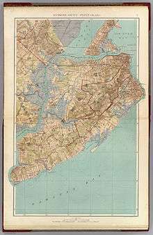
- Joseph Rudolf Bien (1891). Richmond County, Staten Island (Map).
- "Staten Island Time Line". The Staten Island Historian. Retrieved November 3, 2018.
- "A Brief History of Richmond County, Staten Island". NYRICHMO GenWeb. Retrieved September 19, 2013.
- Bayles, Richard Mather (1887). History of Richmond County (Staten Island), New York: From Its Discovery to the Present Time. Madison, WI: . E. Preston & Company. p. 333.