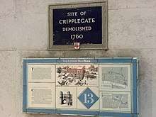
Cripplegate
Cripplegate was a gate in the London Wall and a name for the region of the City of London outside the gate. The area was almost entirely destroyed in the Blitz of World War II and today it is the site of the Barbican Estate and Barbican Centre. The name is preserved in the church of St Giles-without-Cripplegate, in the Cripplegate ward of the City, and in a small road named Cripplegate Street which lies slightly to the north of the site of the Wall between Viscount Street and Bridgewater Street.[2]
| Ward of Cripplegate | |
|---|---|
 Ward of Cripplegate Location within Greater London | |
| Population | 2,782 (2011 Census. Ward)[1] |
| OS grid reference | TQ327811 |
| Sui generis | |
| Administrative area | Greater London |
| Region | |
| Country | England |
| Sovereign state | United Kingdom |
| Post town | LONDON |
| Postcode district | EC3 |
| Dialling code | 020 |
| Police | City of London |
| Fire | London |
| Ambulance | London |
| UK Parliament | |
| London Assembly | |
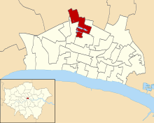
The ward of Cripplegate straddles the former line of the Wall and the old gate, and remains divided into "Within" and "Without" parts,[3] with a beadle and a deputy (alderman) appointed for each part. Since the 1994 (City) and 2003 (ward) boundary changes, most of the ward is Without, with the ward of Bassishaw having expanded considerably into the Within area.
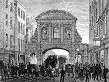
The Gate
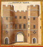
The origins of the gate's name are unclear.[4] One theory, bolstered by a mentioning of the gate in the fourth law code of Æthelred the Unready and a charter of William the Conqueror from 1068 under the name "Crepelgate",[5] is that it takes its name from the Anglo-Saxon word crepel, meaning a covered or underground passageway.
Another unsubstantiated theory suggests it is named after the cripples who used to beg there. The name of the nearby medieval church of St Giles-without-Cripplegate lends credence to this suggestion as Saint Giles is the patron saint of cripples and lepers.
Cripplegate Ward
Cripplegate is one of the 25 ancient wards of the City of London, each electing an alderman to the Court of Aldermen and commoners (the City equivalent of a councillor) to the Court of Common Council of the City of London Corporation. Only electors who are Freemen of the City are eligible to stand. In the early 12th century, the area was originally referred to as Alwoldii which was probably the name of the current alderman.[6] The early records are unreliable as regards who the Aldermen were, but from 1286 there is a more reliable list of Aldermen available.[6]
The modern City of London spreads across a square mile of land and remains divided into 25 geographic areas, or 'Wards'. Four of these Wards (Aldersgate, Portsoken, Queenhithe and Cripplegate), are described as 'Residential' as they contain the vast majority of all City residents.
Geography
The Ward of Cripplegate provides part of the Northern edge of the City and stretches from just below Old Street, down to London Wall at its Southern tip, where it meets the Ward of Bassishaw. To the West is the Ward of Aldersgate and on the Eastern edge is Coleman Street.
The 2003 Ward Boundary Review recommended some significant changes for a number of Wards and these were eventually implemented in 2013.[6]
The Cripplegate Ward boundary used to extend a great deal further South, all the way down to Cheapside in fact. The Ward was home to the Livery Halls of 6 Worshipful Companies and now only one remains (The Barber-Surgeons in Monkwell Square).[6]
Each Ward is represented by an assembly called the 'Court of Common Council'. This consists of 100 Common Councilmen and 25 Alderman (one for each Ward). The number of Councilmen allocated to each particular Ward is based on the size of the electorate and where Cripplegate used to warrant 12 members of Council it is now reduced to 9.[6]
The Ward is promoted by the Cripplegate Ward Club. Founded in 1878, The Cripplegate Ward Club is a social organisation, encouraging its members to take an interest in the Civic affairs of the City, while also supporting appeals and charitable activities. Cripplegate is among the busiest of the 20+ Ward Clubs in the City of London, with a varied programme of events throughout the year. Further information about the Cripplegate Ward Club and the history of Cripplegate can be found on their website.

Politics
Current elected representatives in Cripplegate are David Graves (Alderman), Mark Bostock, David Bradshaw, Mary Durcan, Vivienne Littlechild, Susan Pearson, William Pimlott, Stephen Quilter and John Tomlinson.[7]
In the 2017 City-wide Common Council elections, the Labour Party won two seats in Cripplegate ward with local residents Mary Durcan and William Pimlott making Labour gains.[8] The Labour Party won a record total of five seats on the Common Council in March 2017 winning two seats in Portsoken, two seats in Cripplegate ward and one seat in Aldersgate ward.[9]
Following a boundary change in 1994, the Golden Lane Estate was transferred from Islington to the City, and so Cripplegate is today the most populous of the four residential wards of the City, with a population of 2,782 (2011).
History of the Ward
In 1068, a burial site in Cripplegate, where Jewin Street now stands, was the only place in England where Jews were permitted to be buried. Those living elsewhere in the country were forced, at great expense and inconvenience, to bring their dead there.[10]
In 1555, John Gresham endowed the new Gresham's School in Norfolk with three tenements in the parish of St. Giles Without Cripplegate, including 'The White Hind' and 'The Peacock'.[11]
During the Second World War, the Cripplegate area, a centre of the rag trade,[12] was virtually destroyed and by 1951 the resident population of the City stood at only 5,324, of whom 48 lived in Cripplegate. Discussions began in 1952 about the future of the area, and the decision to build new residential properties was taken by the Court of Common Council on 19 September 1957. The area was reopened as the Barbican Estate in 1969.
Tranter's Hotel was located at 6-9 Bridgewater Square,[13] in a Georgian building with 60 rooms available,[14] not far from today’s Beech Street, before being destroyed by the World War II bombs. It was advertised on a number of periodical and magazines in between 1887 and 1919 as a very centrally located, family and commercial temperance friendly hotel, convenient for St Paul’s Cathedral, Aldersgate station for business and pleasure.[15]
Other uses
Cripplegate Foundation
The foundation dates its origins to the donation of £40 "to provide trousers for local people" on 2 April 1500.[16] However it was only in 1891 that various local trusts were consolidated into the Cripplegate Foundation by the London Parochial Charities Act.[16] Between 1896 and 1973 the foundation ran the Cripplegate Institute.[16] From 1 April 2008 the area of benefit was expanded to include Islington. John Gilbert is the chair of the foundation, having been on the board of governors since 2005.[16]
Cripplegate Bank
The Cripplegate Savings Bank was established in 1819 as a joint stock bank, then re-registered as Cripplegate Bank Ltd in 1879, and finally renamed London, Commercial & Cripplegate Bank Ltd in 1900.[17] In between 1876-1906 the Cripplegate Bank was located at 31 and then 1 Whitecross Street, before been incorporated into the Union Bank of London, and finally been liquidated.[18]
In popular culture
The second wedding in the film Four Weddings and a Funeral takes place in the fictional church of St. Mary of the Fields, Cripplegate, EC2[19] It was filmed in the chapel of the Royal Naval College, Greenwich.[20]
References
- "City of London Ward population 2011". Neighbourhood Statistics. Office for National Statistics. Retrieved 16 October 2016.
- A-Z London. Geographer's A-Z Map Co Ltd. 2001. p. 162. ISBN 0-85039-753-7.
- Cripplegate Ward News Archived 12 June 2011 at the Wayback Machine - note use of "Within" and "Without" on page 4
- Harben, Henry (1918). A Dictionary of London. London.
- 'Saxon London', by Alan Vince, 1990, p43
- Caroline Fiona Gordon (1985), The Ward of Cripplegate in the City of London, London: Cripplegate Ward Club, OL 14531369M
- Find Member - Results by ward: Cripplegate
- In the 2017 City-wide Common Council elections, the Labour Party won two seats in Cripplegate ward with local residents Mary Durcan and William Pimlott making Labour gains
- The Labour Party won a record total of five seats on the Common Council in March 2017 winning two seats in Portsoken, two seats in Cripplegate ward and one seat in Aldersgate ward
- Light for the last days (1888), H Grattan Guinness D.D., FRAS>
- Herbert, William, The History of the Twelve Great Livery Companies of London (London, Wm Herbert, 1836) pp. 80-81 at books.google.co.uk
- Tom Bolton (24 June 2015). "From Cripplegate to Agar Town: inside London's vanished neighbourhoods". The Guardian. Retrieved 24 June 2015.
by the second world war, Cripplegate had become "Fire Island", the highest-insurance-risk area in London, occupied by rag trade warehouses packed with tinder-box stock.
- https://alondoninheritance.com/
- https://archive.org/stream/blacksguidetoed00firgoog/blacksguidetoed00firgoog_djvu.txt
- "An Almanack for the Year of Our Lord". 1848.
- "History". www.cripplegate.org. Cripplegate Foundation Limited. Retrieved 8 December 2017.
- "London, Commercial & Cripplegate Bank Ltd". RBS Heritage Hub. Retrieved 5 June 2019.
- http://discovery.nationalarchives.gov.uk/details/c/F189019
- Sic : Cripplegate is in the EC3 postcode area.
- Four Weddings and a Funeral at movie-locations.com
- Old and New London and A New History of London — two historical sources on the ward from British History Online
- Map of Early Modern London: Cripplegate Ward - Historical Map and Encyclopedia of Shakespeare's London(Scholarly)
External links
- Cripplegate Ward Club - The Social Club and Ward website for the Cripplegate Ward based in the City of London
- City of London Corporation Map of Cripplegate ward (2003 —)
- The City of London Corporation - The Official government website for the City of London. This encompasses all 25 Wards including the Cripplegate Ward
| Wikimedia Commons has media related to Ward of Cripplegate. |
| Wards |  | |
|---|---|---|
| Enclaves | ||
| Localities | ||
| Attractions |
| |
| Notable structures | ||
| Civil parishes | ||
| Bridges |
| |
| Rail and tube stations | ||
| Topics | ||
| ||
Gates and bars of the City of London | |||
|---|---|---|---|
 | Former gates of London Wall and City bars
Listed clockwise from the West
| ||