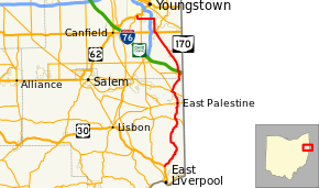
Ohio State Route 170
State Route 170 (SR 170) is a north–south running state route located in Mahoning and Columbiana counties in northeast Ohio. It runs within a few miles of the Pennsylvania border for much of its route as it passes through the eastern parts of the two counties. The southern terminus is at an interchange with U.S. 30, State Route 7, and State Route 11 near Calcutta, and the northern at U.S. 62 in Youngstown. ODOT extended the northern terminus from the previous point of Interstate 680, changing signs on July 16 and 17, 2008.[2]
| ||||
|---|---|---|---|---|
 | ||||
| Route information | ||||
| Maintained by ODOT | ||||
| Length | 36.64 mi[1] (58.97 km) | |||
| Existed | 1924–present | |||
| Major junctions | ||||
| South end | ||||
| North end | ||||
| Location | ||||
| Counties | Columbiana, Mahoning | |||
| Highway system | ||||
| ||||

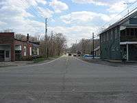
Intersection with State Route 154 in Negley
History
- 1924 – Original state highway.[3]
- 1924 – Originally routed from East Palestine to Petersburg.[3]
- 1931 – Extended to East Liverpool along previous unnumbered road.[3]
- 1962 – Extended to 1-mile (1.6 km) north of North Kingsville along previous route 90.[3]
- 1970 – Truncated at 3 miles (4.8 km) north of Poland.[3]
- 2008 – Extended 3 miles (4.8 km) to U.S. 62 in Youngstown along the former Route 625.[2][4]
Major junctions
| County | Location | mi | km | Destinations | Notes |
|---|---|---|---|---|---|
| Columbiana | Calcutta | 0.00 | 0.00 | Interchange | |
| Negley | 11.18 | 17.99 | Southern end of SR 154 concurrency | ||
| 11.24 | 18.09 | Northern end of SR 154 concurrency | |||
| East Palestine | 14.57 | 23.45 | Southern terminus of SR 46; eastern terminus of SR 558 | ||
| 14.82 | 23.85 | Southern end of SR 165 concurrency | |||
| Unity Township | 16.70 | 26.88 | Southern end of SR 14 concurrency | ||
| 17.24 | 27.75 | Northern end of SR 14 / SR 165 concurrency | |||
| Mahoning | Petersburg | 21.23 | 34.17 | Southern end of SR 617 concurrency | |
| 21.32 | 34.31 | Northern end of SR 617 concurrency | |||
| New Middletown | 26.04 | 41.91 | Western terminus of SR 630 | ||
| Poland | 30.33 | 48.81 | Southern terminus of SR 616 | ||
| 30.39 | 48.91 | ||||
| Youngstown | 33.55 | 53.99 | Exit 9 (I-680) | ||
| 35.33 | 56.86 | ||||
| 36.64 | 58.97 | ||||
1.000 mi = 1.609 km; 1.000 km = 0.621 mi
| |||||
References
- Ohio Department of Transportation. "Technical Services Straight Line Diagrams". Retrieved April 30, 2010.
- "Sign work, I-680 restrictions to be done today". The Vindicator. 2008-07-17. Retrieved 2009-05-12.
- Route 170 by John Simpson Archived March 7, 2008, at the Wayback Machine
- "ODOT SLD: Mahoning County 2008 Updates". Ohio Department of Transportation. January 1, 2008. Retrieved 2009-02-18.
This article is issued from Wikipedia. The text is licensed under Creative Commons - Attribution - Sharealike. Additional terms may apply for the media files.