Eagle Cap Wilderness
Eagle Cap Wilderness is a wilderness area located in the Wallowa Mountains of northeastern Oregon (United States), within the Wallowa–Whitman National Forest.[1] The wilderness was established in 1940. In 1964, it was included in the National Wilderness Preservation System. A boundary revision in 1972 added 73,000 acres (30,000 ha) and the Wilderness Act of 1984 added 66,100 acres (26,700 ha) resulting in a current total of 361,446 acres (146,272 ha; 565 sq mi), making Eagle Cap by far Oregon's largest wilderness area.[2]
| Eagle Cap Wilderness | |
|---|---|
IUCN category Ib (wilderness area) | |
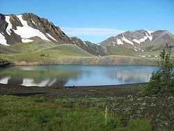
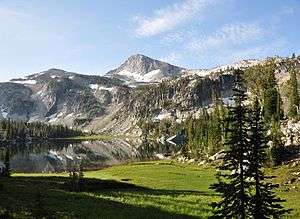 Mirror Lake in the Eagle Cap Wilderness | |
 | |
| Location | Wallowa / Union / Baker counties, Oregon, United States |
| Nearest city | Enterprise, Oregon |
| Coordinates | 45°14′32″N 117°26′30″W |
| Area | 361,446 acres (146,272 ha) |
| Established | 1940 |
| Governing body | U.S. Forest Service |

Eagle Cap Wilderness is named after a peak in the Wallowa Mountains, which were once called the Eagle Mountains. At 9,572 feet (2,918 m) Eagle Cap was incorrectly thought to be the highest peak in the range.[3]
Topography
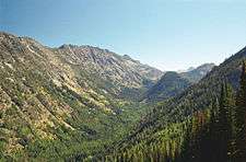
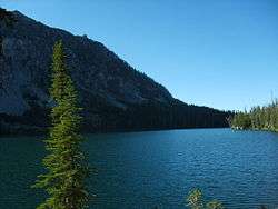
The Eagle Cap Wilderness is characterized by high alpine lakes and meadows, bare granite peaks and ridges, and U-shaped glacial valleys.[1] Thick timber is found in the lower valleys and scattered alpine timber on the upper slopes. Elevations in the wilderness range from approximately 3,000 feet (914 m) in lower valleys to 9,838 feet (2,999 m) at the summit of Sacajawea Peak with 30 other summits exceeding 8,000 feet (2,400 m).[4] The wilderness is home to Legore Lake, the highest lake above sea level in Oregon at 8,950 feet (2,728 m),[5] as well as almost 60 alpine lakes (9 of which are above 8,000 feet),[6] and more than 37 miles (60 km) of streams.[4]
History
The Eagle Cap Wilderness and surrounding country in the Wallowa–Whitman National Forest was first occupied by the ancestors of the Nez Perce Indian tribe around 1400 AD, and later by the Cayuse, the Shoshone, and Bannocks. The wilderness was used as hunting grounds for bighorn sheep and deer and to gather huckleberries. It was the summer home to the Joseph Band of the Nez Perce tribe. 1860 marked the year the first settlers moved into the Wallowa Valley. In 1930, the Eagle Cap was established as a primitive area and in 1940 earned wilderness designation.[1]
Wildlife
Eagle Cap Wilderness is home to a variety of wildlife, including black bears, cougars, Rocky Mountain bighorn sheep, and mountain goats. In the summer white-tailed deer, mule deer, and Rocky Mountain elk roam the wilderness. Smaller mammals that inhabit the area year-round include the pika, pine martens, badgers, squirrels, and marmots. Birds include peregrine falcons, bald eagles, golden eagles, ferruginous hawks, and gray-crowned rosy finch. Trout can be found in many of the lakes and streams in the wilderness.[1] The Oregon State record golden trout was caught in the wilderness in 1987, by Douglas White. The lake where it was caught was not named.
Moose have recently returned to the wilderness; the herd now numbers about 40. There is possible evidence that grizzly bears and wolverines are returning as well.[7][8]
Vegetation
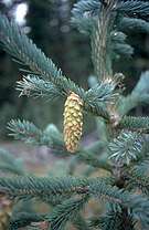
Plant communities in the Eagle Cap Wilderness range from low elevation grasslands and ponderosa pine forest to alpine meadows. Engelmann spruce, larch, mountain hemlock, sub-alpine fir, and whitebark pine can be found in the higher elevations. Varieties of Indian paintbrush, sego lilies, elephanthead, larkspur, shooting star, and bluebells are abundant in the meadows.[1] The wilderness does contain some small groves of old growth forest.[1]
Recreation
As Oregon's largest wilderness area, Eagle Cap offers many recreational activities, including hiking, backpacking, horseback riding, hunting, fishing, camping, and wildlife watching. Winter brings backcountry skiing and snowshoeing opportunities. There are 47 trailheads and approximately 534 miles (859 km) of trails in Eagle Cap, accessible from Wallowa, Union, and Baker Counties, and leading to all areas of the wilderness.[1][9][10]
Wild and Scenic Rivers
Four designated Wild and Scenic Rivers originate in Eagle Cap Wilderness—the Lostine, Eagle Creek, Minam, and Imnaha.
Lostine River
16 miles (26 km) of the Lostine from its headwaters in the wilderness to the Wallowa–Whitman National Forest boundary are designated Wild and Scenic. Established in 1988, 5 miles (8 km) of the river are designated "wild" and 11 miles (18 km) are designated "recreational." A small portion of the river is on private property.[11]
Eagle Creek
27 miles (43 km) of Eagle Creek from its output at Eagle Lake in the wilderness to the Wallowa–Whitman National Forest boundary at Skull Creek are designated Wild and Scenic. In 1988, 4 miles (6 km) of the river were designated "wild," 6 miles (10 km) are designated "scenic," and 17 miles (27 km) are designated "recreational."[12]
Minam
39 miles (63 km) of the Minam River from its headwaters at the south end of Minam Lake to the wilderness boundary, one-half mile downstream from Cougar Creek, are designated Wild and Scenic. In 1988, all 39 miles (63 km) were designated "wild."[13]
Imnaha
77 miles (124 km) of the Imnaha River from its headwaters are designated Wild and Scenic. The designation comprises the main stem from the confluence of the North and South Forks of the Imnaha River to its mouth, and the South Fork from its headwaters to the confluence with the main stem. In 1988, 15 miles (24 km) were designated "wild," 4 miles (6 km) were designated "scenic," and 58 miles (93 km) were designated "recreational," though only a portion of the Wild and Scenic Imnaha is located within Eagle Cap Wilderness.[14]
Lakes

| Name | Elevation[15][16] |
|---|---|
| Aneroid Lake | 7,500 ft (2,300 m) |
| Bear Lake | 7,905 ft (2,409 m) |
| Billy Jones Lake | 8,400 ft (2,600 m) |
| Blue Lake | 7,703 ft (2,348 m) |
| Bonny Lakes | 7,840 ft (2,390 m) |
| Catched Two Lake | 7,980 ft (2,430 m) |
| Cheval Lake | 7,801 ft (2,378 m) |
| Chimney Lake | 7,604 ft (2,318 m) |
| Crescent Lake | 7,371 ft (2,247 m) |
| Dollar Lake | 8,300 ft (2,500 m) |
| Douglas Lake | 7,326 ft (2,233 m) |
| Echo Lake | 8,372 ft (2,552 m) |
| Echo Lake | 7,020 ft (2,140 m) |
| Frances Lake | 7,705 ft (2,348 m) |
| Frazier lake | 7,127 ft (2,172 m) |
| Glacier Lake | 8,166 ft (2,489 m) |
| Green Lake | 6,699 ft (2,042 m) |
| Horseshoe Lake | 7,133 ft (2,174 m) |
| Ice Lake | 7,849 ft (2,392 m) |
| Jewett Lake | 8,240 ft (2,510 m) |
| John Henry Lake | 7,168 ft (2,185 m) |
| Laverty Lake | 7,500 ft (2,300 m) |
| Lee Lake | 7,145 ft (2,178 m) |
| Legore Lake | 8,950 ft (2,730 m) |
| Little Storm Lake | 7,580 ft (2,310 m) |
| Maxwell Lake | 7,729 ft (2,356 m) |
| Minam Lake | 7,373 ft (2,247 m) |
| Mirror Lake | 7,595 ft (2,315 m) |
| Moccasin Lake | 7,473 ft (2,278 m) |
| Prospect Lake | 8,328 ft (2,538 m) |
| Pocket Lake | 8,225 ft (2,507 m) |
| Razz Lake | 8,103 ft (2,470 m) |
| Roger Lake | 7,360 ft (2,240 m) |
| Steamboat Lake | 7,363 ft (2,244 m) |
| Swamp Lake | 7,837 ft (2,389 m) |
| Tombstone Lake | 7,421 ft (2,262 m) |
| Traverse Lake | 7,723 ft (2,354 m) |
| Unit Lake | 7,007 ft (2,136 m) |
| Wood Lake | 7,338 ft (2,237 m) |
See also
- List of Oregon Wildernesses
- List of U.S. Wilderness Areas
- List of old growth forests
References
- Wallowa–Whitman National Forest - Eagle Cap Wilderness
- Eagle Cap Wilderness, Oregon Archived 2010-05-13 at the Wayback Machine - GORP
- McArthur, Lewis A.; Lewis L. McArthur (2003) [1928]. Oregon Geographic Names (Seventh ed.). Portland, Oregon: Oregon Historical Society Press. ISBN 0-87595-277-1 (trade paperback), ISBN 0-87595-278-X (hardcover).
- "Eagle Cap Wilderness". Wilderness.net. Retrieved 2009-08-06.
- http://www.fishingworks.com/lakes/oregon/wallowa/chief-joseph-mountain/legore-lake/
- http://www.fs.fed.us/r6/w-w/recreation/wilderness/elevations-ecw.shtml
- "Moose enter Oregon, so are grizzlies next?". Tri-City Herald. Archived from the original on 2014-07-06. Retrieved Nov 1, 2008.
- "Wolverines in Oregon? The rumors are true". OPB.
- Wallowa–Whitman National Forest - Majestic Eagle Cap Wilderness Recreation
- Wallowa–Whitman National Forest - List of trails in the Eagle Cap Ranger District
- National Wild and Scenic Rivers System Archived 2010-06-10 at the Wayback Machine - Lostine River
- National Wild and Scenic Rivers System Archived 2011-05-20 at Archive.today - Eagle Creek
- National Wild and Scenic Rivers System Archived 2010-06-10 at the Wayback Machine - Minam River
- National Wild and Scenic Rivers System Archived 2009-03-25 at the Wayback Machine - Imnaha River
- http://www.fs.fed.us/r6/w-w/recreation/wilderness/elevations-ecw.shtml Retrieved on November 24, 2008
- http://www.fishingworks.com/lakes/oregon/union/
External links
- Eagle Cap Wilderness - Wallowa–Whitman National Forest
- Eagle Cap Wilderness - Wilderness.net
- EagleCapWilderness.com
- Eagle Cap Wilderness - JosephOregon.com