Aneroid Lake
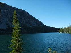
Aneroid Lake is a large tarn located on Aneroid Mountain in the Eagle Cap Wilderness of northeastern Oregon. It is situated in between Roger Lake and Dollar Lake.[1] It is not accessible by any kind of motor vehicle. However, there is a popular hiking trail that leads to the lake. There is a small group of private cabins near the south end and Pete's Point is clearly visible from the lake.[2] It ties with Laverty Lake as the twenty-third highest lake in the Eagle Cap Wilderness at 7,500 ft (2,300 m).[3]
| Aneroid Lake | |
|---|---|
 | |
| Location | Eagle Cap Wilderness, Wallowa County, Oregon |
| Coordinates | 45.2082°N 117.2043°W |
| Type | Tarn |
| Basin countries | United States |
| Max. length | 653 yd (597 m) |
| Max. width | 478 yd (437 m) |
| Average depth | 348 ft (106 m) |
| Max. depth | 560 ft (170 m) |
| Surface elevation | 7,500 ft (2,300 m) |
Backcountry skiing
Being surrounded by slopes that are typically covered in snow as early as October, Aneroid Lake has become a popular backcountry skiing destination. Guided tours are available, some tours utilize the cabins at the lake.[4]
Fatalities
The area is known for unexpected avalanches, which at times have caused fatalities. One of the earliest avalanche caused fatalities on record that occurred at Aneroid Lake was on February 14, 1981, when an avalanche killed one skier near the lake.[5] Through not a single avalanche-related death had occurred at lake since 1981, on March 7, 2009, a 50-year-old skier was killed near the lake. Roger T. Roepke, his 15-year-old son, and 48-year-old Don Woodhouse were part of a group who was skiing about one half mile above the Aneroid Lake cabins when a quarter-mile-long slab avalanche occurred, burying the three skiers. The avalanche began at about 1 p.m. and slid approximately 1,000 feet (300 m) before the run-out. It received a 3.5 danger scale rating by the American Avalanche Association. Don Woodhouse and the 15-year-old Roepke survived the event. However, after 30 minutes of CPR and other life saving measures, Roger Roepke was considered dead.[6][7]
SNOTEL

One half mile east of Aneroid Lake is Aneroid Lake Snotel #2, which is one of the two SNOTELs in the Eagle Cap mountains. It measures the depth of the snow, the amount of water content in the snow, general precipitation, and air temperature. It is operated by the Natural Resources Conservation Service and was installed in 1982.[9]
Trail
Aneroid Lake can be accessed by either the East Fork Wallowa River Trailhead at Wallowa Lake or Tenderfoot Trailhead. The East Fork Wallowa River Trailhead is by far a shorter hike to Aneroid Lake, being only 6 miles (9.7 km) long. It begins at the south end of Wallowa Lake, near Wallowa Lake State Park. After about 2 miles (3 km) of hiking on the East Fork Wallowa River Trail, the climber will reach a small dam. At 3.8 miles (6.1 km) there is a small, well built bridge. At 5.5 miles (8.9 km) lies Roger Lake.[10] The trail is usually well maintained. It may be heavily traveled in the summer months.[11]

See also
- List of lakes in Oregon
References
- Frank Barstad, p. 276 Hiking Oregon's Eagle Cap Wilderness (c) 2002 Morris Book Publishing
- "Archived copy". Archived from the original on 2008-07-05. Retrieved 2008-11-25.CS1 maint: archived copy as title (link) Retrieved 2008-11-25.
- "Elevations of Points Near Eagle Cap Wilderness". U.S. Forest Service. Archived from the original on 2009-05-12.
- {{cite web|url=http://www.kryzzell.net/aneroid/%5B%5D
- http://www.i-world.net/oma/avalanche/avalanche-history.html Archived 2009-05-28 at the Wayback Machine Retrieved 2009-03-02.
- http://www.lagrandeobserver.com/News/Local-News/Aneroid-avalanche-claims-Enterprise-skier Retrieved 2009-06-18.
- "Archived copy". Archived from the original on 2016-03-03. Retrieved 2009-06-18.CS1 maint: archived copy as title (link) Retrieved 2009-06-18.
- Data collected from ftp://ftp.wcc.nrcs.usda.gov/data/climate/table/temperature/history/oregon/17d02s_tmax.txt%5B%5D on 2009-02-20.
- Aneroid Lake SNOTEL #2 Archived February 4, 2009, at the Wayback Machine Retrieved 2009-02-19.
- http://www.trailsnw.com/index.php?fuseaction=Trails.DisplayTrail&hike_num=42 Retrieved 2008-11-25.
- "East Fork Wallowa Trail #1804" (PDF). U.S. Forest Service. Retrieved 2014-12-22.
External links
- Aneroid Lake SNOTEL #2
- Wing Ridge Ski Tours (provides professional guided back country ski tours to Aneroid lake)