Pilot Butte (Oregon)
Pilot Butte is a lava dome that was created from an extinct volcano located in Bend, Oregon. It is a cinder cone butte which rises nearly 500 feet (150 m) above the surrounding plains. Bend is one of four cities in the United States to have a volcano within its boundaries. Portland, with Mount Tabor, is the only other city in Oregon with a volcano within its city limits. Jackson Volcano in Jackson, Mississippi, and Diamond Head in Honolulu are the others.
| Pilot Butte | |
|---|---|
 | |
| Highest point | |
| Elevation | 4,142 ft (1,262 m) NAVD 88[1] |
| Prominence | 480 ft (150 m) [2] |
| Coordinates | 44°03′38″N 121°17′00″W [1] |
| Geography | |
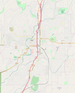 Pilot Butte 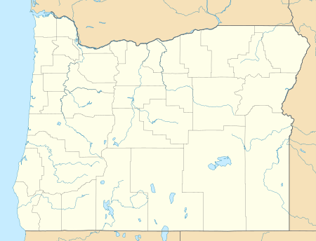 Pilot Butte Pilot Butte (Oregon) | |
| Parent range | Cascades |
| Topo map | USGS Bend |
| Geology | |
| Age of rock | Less than 780,000 years[3] |
| Mountain type | Cinder cone |
| Volcanic arc | Cascade Volcanic Arc |
| Climbing | |
| Easiest route | Road |
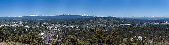
The 114.22-acre (46.22 ha) Pilot Butte State Scenic Viewpoint, presented as a gift to the State of Oregon in 1928,[4] is a Bend icon. Pilot Butte itself is a popular hiking destination with two trails to the summit, each gaining about 490 feet (150 m) in elevation. There is also a 1.8-mile (2.9 km) trail around the base of Pilot Butte that was constructed in 2010. A scenic road also winds up and around the cone. The park had 949,968 annual visits in 2018, making it the most visited Oregon State Park east of the Cascade Mountains and the ninth most popular in the state.[5] From the top, the entire city of Bend is visible, as well as several major Cascade peaks. Most prominent are the Three Sisters, Broken Top, and Mount Bachelor, which are located about 20 miles (32 km) to the west. The City of Bend launches Fourth of July fireworks from Pilot Butte each year.[6] Pilot Butte was named in 1851 by Thomas Clark, leader of the first party of European settlers to camp on the future site of Bend. The Clark wagon train approached the area from the east after recovering from the Clark Massacre.
Geology
Pilot Butte is believed to be less than 780,000 years old due to the rock having normal polarity, and thus most likely laid down after the most recent reversal.
References
- "Pilot Butte". NGS data sheet. U.S. National Geodetic Survey. Retrieved 2008-04-02.
- "Pilot Butte, Oregon". Peakbagger.com. Retrieved 2008-04-02.
- "USGS Geologic Investigations Series Map I-2683, pamphlet" (PDF). U.S. Department of the Interior and U.S. Geological Survey. 2004. Retrieved 2018-10-28.
- "Pilot Butte Is Presented To State For Public Park". Bend Bulletin. October 1, 1928. Retrieved 14 April 2013.
- "The 20 most popular Oregon state parks in 2018". oregonlive.com. The Oregonian. Retrieved 27 April 2020.
- "July 4th Fireworks Spectacular". Bend Oregon Visitor Bureau for Hotels, Lodging, or Restaurants. Retrieved 2013-01-12.
External links
| Wikimedia Commons has media related to Pilot Butte State Scenic Viewpoint. |
- "Pilot Butte". Geographic Names Information System. United States Geological Survey. Retrieved 2008-04-02.
- "Pilot Butte State Scenic Viewpoint". Oregon Parks and Recreation Department. Retrieved 2008-04-01.
- "Pilot Butte, Oregon". USGS Cascades Volcano Observatory. Retrieved 2008-04-01.
- Pilot Butte State Scenic Viewpoint, from The Oregon Encyclopedia