Dungannon
Dungannon (from Irish: Dún Geanainn, meaning "Geanann's fort")[1] is a town in County Tyrone, Northern Ireland. It is the third-largest town in the county (after Omagh and Strabane) and had a population of 14,340 at the 2011 Census.[2] The Dungannon and South Tyrone Borough Council had its headquarters in the town, though since 2015 it has been covered by Mid-Ulster District Council.
Dungannon
| |
|---|---|
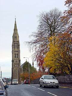 St Patrick's Roman Catholic church | |
 Dungannon Coat of Arms | |
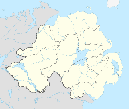 Dungannon Location within Northern Ireland | |
| Population | 14,340 (2011 Census) |
| Irish grid reference | H7962 |
| • Belfast | 40 miles (64 km) |
| District |
|
| County | |
| Country | Northern Ireland |
| Sovereign state | United Kingdom |
| Post town | DUNGANNON |
| Postcode district | BT70, BT71 |
| Dialling code | 028 |
| Police | Northern Ireland |
| Fire | Northern Ireland |
| Ambulance | Northern Ireland |
| UK Parliament | |
| NI Assembly | |
For centuries, it was the 'capital' of the O'Neill dynasty of Tír Eoghain, who dominated most of Ulster and built a castle on the hill. After the O'Neills' defeat in the Nine Years' War, the English founded a plantation town on the site, which grew into what is now Dungannon. Dungannon has won Ulster in Bloom's Best Kept Town Award five times. It currently has the highest percentage of immigrants of any town in Northern Ireland.
History
.jpg)
.jpg)
For centuries, Dungannon's fortunes were closely tied to that of the O'Neill dynasty which ruled a large part of Ulster until the 17th century. Dungannon was the clan's main stronghold. The traditional site of inauguration for 'The O'Neill', was Tullyhogue Fort, an Iron Age mound some four miles northeast of Dungannon. The clan O'Hagan were the stewards of this site for the O'Neills. In the 14th century, the O'Neills built a castle on what is today known as Castle Hill; the location was ideal for a fort as it was one of the highest points in the area, and dominated the surrounding countryside with the ability to see seven counties depending on the weather.
This castle was burned in 1602 by Hugh O'Neill, 2nd Earl of Tyrone as Crown forces under Lord Mountjoy closed in on the Gaelic lords towards the end of the Nine Years' War. In 1607, ninety-nine Irish chieftains and their followers, including Hugh O'Neill, set sail from Rathmullan, bound for the continent. What followed became known as the Plantation of Ulster and the town and its castle were granted to Sir Arthur Chichester, one of the architects of the plantation.
In 1641 after seizing the town in the opening stages of the Irish Rebellion, Sir Phelim O'Neill issued the Proclamation of Dungannon in which the rebels set out their aims and proclaimed their loyalty to Charles I. O'Neill hinted that they had been ordered to rise by the King and later produced a commission which he claimed Charles had issued to him.

The castle was partially excavated in October 2007, by the Channel 4 archaeological show Time Team, uncovering part of the moat and walls of the castle. In 1973, the town became the seat of the new district of the Dungannon and South Tyrone Borough Council. In 1782, the town was the location where the independence of the Irish Parliament was declared by members of the Protestant Ascendancy who controlled the parliament at the time.[3]
The Troubles
In the late 1960s, Northern Ireland was plunged into an ethnopolitical conflict known as the Troubles. During the conflict almost 50 people were killed in and around Dungannon,[4] and there were many bombings in the town. The deadliest attack in the town was on 17 March 1976, when a loyalist car bomb attack on the Hillcrest Bar killed four Catholic civilians.
On 24 August 1968, the Campaign for Social Justice (CSJ), the Northern Ireland Civil Rights Association (NICRA), and other groups, held Northern Ireland's first civil rights march from Coalisland to Dungannon. The rally was officially banned, but took place and passed off without incident. The publicity surrounding the march encouraged other groups to form branches of NICRA.[5]
Demography
Dungannon had a population of 14,340 at the 2011 census.[2] It has the highest percentage of immigrants of any town in Northern Ireland.[6] Immigrants make up about 11% of its population; more than twice the average. Between 2001 and 2011, the number of immigrants in Dungannon increased tenfold; the biggest increase of any town.[6] Many came to work in the local food processing plants. There have been several attacks on immigrants[7] and clashes between rival groups of immigrants[8] in the area.
The population of the town increased slightly overall during the 19th century:[9][10]
| Year | 1841 | 1851 | 1861 | 1871 | 1881 | 1891 |
|---|---|---|---|---|---|---|
| Population | 3,801 | 3,854 | 3,994 | 3,886 | 4,084 | 3,812 |
| Houses | 675 | 686 | 720 | 727 | 812 | 830 |
On Census day (27 March 2011) there were 14,340 people living in Dungannon (5,388 households), accounting for 0.79% of the NI total.[2] Of these:
- 22.01% were aged under 16 years and 12.09% were aged 65 and over;
- 50.33% of the usually resident population were female and 49.67% were male;
- 64.82% belong to or were brought up in the Catholic religion and 30.46% belong to or were brought up in a 'Protestant and Other Christian (including Christian related)' religion;
- 31.63% had an Irish national identity, 28.27% indicated that they had a British national identity and 23.93% had a Northern Irish national identity (respondents could indicate more than one national identity);
- 34 years was the average (median) age of the population;
- 15.93% had some knowledge of Irish (Gaelic), 4.82% had some knowledge of Ulster-Scots and 23.18% did not have English as their first language.
Places of interest
An interesting feature of the town is the former police barracks at the top right-hand corner of the market square which is quite unlike any other barracks of a similar vintage in Ireland. A popular but apocryphal story relates that the unusual design of this building is due to a mix-up with the plans in Dublin which meant Dungannon got a station designed for Nepal and they got a standard Irish barracks, complete with a traditional Irish fireplace. Dungannon Park is a seventy-acre oasis centred round an idyllic still-water lake, with miles of pathways and views of the surrounding townland.[11][12]
Geography
Dungannon is in the southeast of County Tyrone, within the historic barony of Dungannon Middle and the civil parish of Drumglass.[13]
The town grew up around a hill, known locally as Castle Hill. There are three small lakes on the southern edge of town, the biggest of which is Black Lough. There are also two parks in the eastern part of town: Dungannon Park and Windmill Park. Surrounding settlements include Moygashel (a village at the southern edge of Dungannon), Coalisland (to the northeast), Donaghmore (to the northwest), Eglish (to the south) and Castlecaulfield (to the west).
Townlands
Dungannon sprang up in a townland called Drumcoo. Over time, the urban area has spread into the neighbouring townlands. Many of its roads and housing estates are named after them. The following is a list of these townlands and their likely etymologies:[14][15]
- Ballynorthland Park
- Ballysaggart (from Irish: Baile na Sagart, meaning "homestead of the priests")
- Coolhill (from Cúlchoill meaning "the backwoods")
- Drumcoo (from Druim Cuaiche meaning "ridge of the cuckoo")
- Drumharriff (from Druim Thairbh meaning "ridge of the bull")
- Gortmerron (from Gort Mearain meaning "Merron's field")
- Killymaddy (from Coill na Madaí meaning "wood of the dogs")
- Killymeal (from Coill na Maoile meaning "wood of the bald/hornless cow")
- Lisnaclin (from Lios na Clinge meaning "ringfort of the bell chime")
- Lisnahull (from Lios a' Choill meaning "ringfort of the hazel")
- Lurgaboy (from Lurga Buí meaning "yellow shin" i.e. shin-shaped hill)
- Mullaghadun (from Mullach a' Dúin meaning "hilltop of the fort")
- Mullaghanagh (from Mullán na hÁithe meaning "hillock of the kiln")
- Mullaghconor (from Mullach Conchobhair meaning "Conchobhar's hilltop")
- Mullaghmore (from Mullach Mór meaning "big hilltop")
Economy
The economy of Dungannon has evolved from agriculture and linen production dominating the landscape to food and light engineering being the main industrial employers. A well-known crystal glass producer was Tyrone Crystal.
Schools
- Primary
- Aughamullan (Holy Family) Primary School (RC)
- Bush Primary School
- Clintyclay Primary School
- Derrylatinee Primary School (RC)
- Donaghey Controlled Primary School
- Dungannon Primary School
- Killyman Primary School
- Laghey Primary School (RC)
- Lisfearty Primary School
- Newmills Primary School
- Orchard County Primary School (amalgamation of Annaghmore and Tullyroan primary schools)
- St Mary's Primary School
- St Patrick's Primary School
- Tamnamore Primary School
- Walker Memorial Primary School
- Windmill Integrated Primary School
- Secondary
- Royal School Dungannon
- Integrated College Dungannon
- St Patrick's Academy, Dungannon[16]
- Drumglass High School
- St Patricks's College, Dungannon
Transport
Dungannon is linked to the M1 motorway, which runs from the southeast of the town to Belfast. There is an Ulsterbus town bus service that runs daily that serves the town's suburbs.[17] Formally operated by the Optare Solo buses. The nearest railway station is Portadown on Northern Ireland Railways.
Former railways
The Irish gauge 1,600 mm (5 ft 3 in) Portadown, Dungannon and Omagh Junction Railway (PD&O) linked the town with Portadown from 1858 and Omagh from 1861,[18] completing the Portadown – Derry railway route that came to be informally called "The Derry Road".[19] The Great Northern Railway took over the PD&O in 1876[20] and built a branch line from Dungannon to Cookstown in 1879.[18]
The GNR Board cut back the Cookstown branch to Coalisland in 1956[21] and the Ulster Transport Authority (UTA) closed the branch altogether in 1959.[21] In accordance with the Benson Report submitted to the Government of Northern Ireland 1963 the UTA closed the "Derry Road" through Dungannon in 1965.[21][22] The site of Dungannon station is now a public park and the former trackbed through the station is now a greenway.
Notable people
- Adrian Logan, television presenter
- Austin Currie, former member of the Parliament of Northern Ireland and Dáil Éireann
- Bernadette Devlin McAliskey, former British MP; Irish republican activist
- Birdy Sweeney, actor
- Colin Morgan, actor
- Darren Clarke, professional golfer
- Fra Fee, film, stage actor
- Gareth Steenson, rugby union player
- Geraldine McQueen, artist
- Gerry McGeough, Provisional Irish Republican Army volunteer; prison escapee
- Gerry McKenna, MRIA, biologist, Senior Vice President of the Royal Irish Academy, Vice Chancellor and President of University of Ulster[23]
- Joanne Salley, television presenter
- Kris Meeke, rally driver[24]
- Niall McGinn, footballer
- Michaella McCollum Connolly, criminal (convicted drug smuggler)[25]
- Patrick Wallace, snooker player
- Richard Dowse (1824–1890), judge
- Ryan Farquhar, motorcycle racer
- Sister Nivedita (born Margaret Elizabeth Noble), social worker, author, teacher and disciple of Swami Vivekananda
- Thomas J. Clarke, the first signatory of the 1916 Proclamation of the Irish Republic; executed by the British authorities
- Thomas Wilson Spence, Wisconsin lawyer and state politician
- U.S. Senator George T. Oliver and his brother, Pittsburgh industrialist Henry W. Oliver (both born in Dungannon in the 1840s)
- Victor Sloan, artist
Sport
Cricket
Dungannon Cricket Club is the oldest sporting club in Dungannon dating back to at least 1865. The club played continuously through to 1914 with a break from 1901-04 when Lord Ranfurly was Governor of New Zealand and there was no ground available until his return. The club became affiliated to the NCU in 1913 and played in the Junior Cup in 1913 and 1914 until the club was discontinued during the Great War.
Attempts were made to reestablish the club after the war and this was done in 1929 and survived until 1933 when Lord Ranfurly died to again leave the club without a ground. Cricket was kept alive by the Royal School, Bankers and the RUC until 1939 when the Second World War broke out. The club was reformed in 1948 mainly due to the efforts of Eddie Hodgett and the NCU leagues in 1952 and continues to do so to the present time. The club has never quite reached senior cricket as it has limited resources and relies on the District Council for a ground. The club has played on at least five different locations during its existence. Home games are played at Dungannon Park.[26]
Football
Dungannon Swifts F.C. is the town's local team, which plays in the IFA Premiership, and is Tyrone's only representative in the league, following Omagh Town's collapse. The club represented Northern Ireland in European competition in 2005–06 and 2006-06.
Gaelic games
The town has also achieved much success in Gaelic games, Gaelic football and hurling. Dungannon has produced many footballers, especially for the Tyrone County Team, who won the All-Ireland Gaelic Football Championship in 2003, 2005 and 2008.
The local boys' Gaelic football club is Dungannon Thomas Clarkes (Thomáis Uí Chléirigh Dún Geanainn) while the ladies' football team is Aodh a Ruadh. The local hurling club is Eoghan Ruadh Dungannon and the Camogie club is Naomh Treasa.
Golf
PGA tour golfer Darren Clarke grew up in Dungannon, and was a member of Dungannon Golf Club. The club is one of the oldest 18-hole courses in Northern Ireland, having been founded in 1890.
Hare coursing and greyhound racing
The local Hare Coursing Club has been in existence since the 1920s but the sport was popular in the area long before the formation of the club. With hare coursing currently banned in Northern Ireland the Dungannon club organises meetings in the Republic of Ireland. Greyhound racing was a popular sport in Dungannon from the 1940s until the Oaks Park Greyhound Stadium finally closed in January 2003. Large crowds attended the weekly meetings on Tuesdays, Wednesdays and Saturdays with visitors travelling from as far away as Dublin to enjoy the races.[27][28]
Rugby
Dungannon was one of the first towns in Ireland to form a rugby club. Dungannon Rugby FC's most recent success was sharing the Ulster Senior League title with Ballymena. They were also the first Ulster club to win the All Ireland League. The rugby club was founded in 1873 and was a founder member of the IRFU. Despite being a rugby union club since inception its official title is Dungannon Football Club.
See also
- Abbeys and priories in Northern Ireland (County Tyrone)
- List of towns and villages in Northern Ireland
- List of localities in Northern Ireland by population
- O'Neill dynasty
- Tullyhogue Fort
References
- "Dún Geanainn/Dungannon". Logainm.ie. 3 November 2015. Retrieved 17 June 2016.
- "Census 2011 Population Statistics for Dungannon Settlement". Northern Ireland Statistics and Research Agency (NISRA). Retrieved 10 August 2019.
- 'Dungannon' from Britannica 2001 Deluxe Edition CD-ROM, 1999–2000.
- CAIN, cain.ulst.ac.uk; accessed 17 June 2016.
- "A Chronology of the Conflict – 1968". Conflict Archive on the Internet (CAIN). Retrieved 7 September 2014.
- "NI migrant population triples in decade, says study". BBC News. 26 June 2014.
- "Politicians unite to condemn ‘racist’ sign in Moygashel", Tyrone Courier, 8 January 2014; accessed 7 September 2014.
- "Loyalists blamed as racist attacks on migrants double in Ulster", The Guardian, 30 May 2006.
- "Census of Ireland 1851". Enhanced Parliamentary Papers on Ireland. Retrieved 21 March 2013.
- "Census of Ireland 1891". Enhanced Parliamentary Papers on Ireland. Retrieved 21 March 2013.
- Discover Northern Ireland – Dungannon Park, Discovernorthernireland.com; accessed 25 September 2015.
- Dungannon Park – Tourist attraction in Dungannon district, Inthedistrict.com; accessed 25 September 2015.
- "Townlands of County Tyrone". IreAtlas Townland Database. Retrieved 21 March 2013.
- "Northern Ireland Placenames Project".
- "OSI Dungannon". Ordnance Survey Ireland. Archived from the original on 29 August 2012. Retrieved 2 July 2010.
- "Home". Stpatrickscollege-dungannon.net. Retrieved 17 June 2016.
- "Archived copy". Archived from the original on 20 October 2004. Retrieved 27 May 2010.CS1 maint: archived copy as title (link)
- Hajducki, S. Maxwell (1974). A Railway Atlas of Ireland. Newton Abbott: David & Charles. map 8. ISBN 0-7153-5167-2.
- FitzGerald, J.D. (1995). The Derry Road. Colourpoint Transport. Gortrush: Colourpoint Press. ISBN 1-898392-09-9.
- Hajducki, op. cit., page xiii
- Hajducki, op. cit., map 39
- Baker, Michael H.C. (1972). Irish Railways since 1916. London, UK: Ian Allan. pp. 155, 209. ISBN 0711002827.
- "Professor P. G. (Gerry) McKenna". www.gerrymckenna.co.uk. Retrieved 4 July 2017.
- "Archived copy". Archived from the original on 22 April 2009. Retrieved 9 June 2009.CS1 maint: archived copy as title (link)
- Brennan, Colin (1 April 2016). "Michaella McCollum Connolly released from jail in Peru". Retrieved 4 July 2017.
- "Dungannon Cricket Club". Dungannoncricketonline.moonfruit.com. Retrieved 16 June 2016.
- "Dungannmon" (PDF). Greyhoundracinghistory.co.uk. Retrieved 17 June 2016.
- Owen Bowcott. "Northern Ireland bans hare coursing". The Guardian. Retrieved 5 April 2016.
External links
| Wikimedia Commons has media related to Dungannon. |
| Wikivoyage has a travel guide for Dungannon. |
List of towns by population | ||
| Large |  | |
| Medium | ||
| Small | ||
Italics denote settlements that are classed as towns but also have city status
| ||
| Authority control |
|
|---|