Ballycastle, County Antrim
Ballycastle (from Irish: Baile an Chaistil, meaning "town of the castle")[4][5] is a small seaside town in County Antrim, Northern Ireland. It is on the north-easternmost coastal tip of Ireland, in the Antrim Coast and Glens Area of Outstanding Natural Beauty. The harbour hosts the ferry to Rathlin Island, which can be seen from the coast. The Ould Lammas Fair is held each year in Ballycastle on the last Monday and Tuesday of August. Ballycastle is the home of the Corrymeela Community.
| Ballycastle | |
|---|---|
 Ballycastle harbour | |
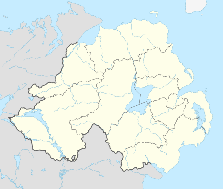 Ballycastle Location within Northern Ireland | |
| Population | 5,237 (2011 Census) |
| Irish grid reference | D115407 |
| • Belfast | 55 miles (89 km) |
| District |
|
| County | |
| Country | Northern Ireland |
| Sovereign state | United Kingdom |
| Post town | BALLYCASTLE |
| Postcode district | BT54 |
| Dialling code | 028 |
| Police | Northern Ireland |
| Fire | Northern Ireland |
| Ambulance | Northern Ireland |
| UK Parliament | |
| NI Assembly | |
| Website | www.northantrim.com |

Ballycastle had a population of 5,237 at the 2011 census.[6] It was the seat and main settlement of the old Moyle District Council. Ballycastle was named the best place to live in Northern Ireland in a list compiled by The Sunday Times in 2016.
Demography
At the time of the 2011 Census the population of Ballycastle was 5,237.[6] Of these:
- 20.2% were aged under 16 years and 17.5% were aged 65 and over
- 47.5% of the population were male and 52.5% were female
- 77.1% were from a Catholic and 19.0% were from a Protestant or other Christian background
- 7.1% of people aged 16–74 were unemployed
Places of interest
- Fair Head, Ballycastle's headland rises 196 metres (643 ft) out of the bay. Goats roam the rocks beneath the cliff tops, where a walkway called 'The Gray Man's Path' winds around the coastline. From the road, a man-made Iron Age island or crannog can be seen in the middle of a large lake.[7]
- Knocklayde, a heather-covered mountain with a height of 1,695 feet, is crowned by Carn na Truagh (the cairn of sorrow), and has views over Ballycastle, Rathlin Island, Fair Head, and Scotland.[8]
- Glentaisie, the most northerly of the Nine Glens of Antrim, lies at the foot of Knocklayde mountain. It is named after the Princess Taisie, the daughter of King Dorm of Rathlin Island. According to legend, Taisie, renowned for her great beauty, was betrothed to Congal, heir to the Kingdom of Ireland. The king of Norway also sought her hand in marriage, and when he arrived to claim his bride, her wedding celebrations to Congal had begun. The king and his army tried to capture Taisie, but in the subsequent battle he was killed, and his army fled leaderless and empty-handed.
- The Carey, Glenshesk and Tow Rivers flow down from the glens into the Margy River. It then flows into the Moyle Sea at the start of the Strand.[9]
- The Strand's Ballycastle Beach is designated a Blue Flag beach.
- Pans Rocks, which are the remains of an iron salt pan lying at the far end of Ballycastle Beach, jut out into the sea and are used as a location for fishing.
- The Devils Churn, lying just beyond Pans Rocks, has steps carved into the stone leading to an underwater tunnel.
- Clare Park on Clare Road, was an estate owned by the then-local landed gentry, the McGildownys. The 17th-century house has been pulled down but it was set in a site high up on the Antrim coast.
- A cycling route runs from Ballycastle to Cushendun, by way of Torr Head, from which Moyle (the North Channel) can be seen. Also used for inshore sea fishing, Torr Head has a coastguard station, which was built on and out of the remains of Dunvarragh, the fort of Barach.
- The Corrymeela Community (a Christian organisation promoting peace and reconciliation, founded in 1965) is based at Corrymeela, just outside Ballycastle.
- Overlooking the harbour, there is a monument to Guglielmo Marconi whose employees made the world's first commercial wireless telegraph transmission between Ballycastle and the East Lighthouse on Rathlin Island.
Buildings of note
- Holy Trinity Parish Church is a Church of Ireland church situated in The Diamond, i.e., the main square. Like the rest of The Diamond, the church is grade 'A' listed. Built by Colonel Hugh Boyd, who bore the total cost, the church was completed in 1756 and is popularly known as Boyd's Church. It was built in Graeco-Italian style with an apse-shaped chancel, and an octagonal spire about 100 feet high. It was effectively a chapel for the Boyd family and its estate for many years. The remains of many Boyd descendants are in the vaults below - although it was always subject to Episcopal jurisdiction. It was given to the Church of Ireland in about 1950. The church is open every day from 9am-5pm.
- Bonamargy Friary is off the Cushendall Road on the approach to Ballycastle and is a late Franciscan foundation established in 1485 by Rory MacQuillan. Locked vaults hold the remains of the celebrated chieftain, Sorley Boy MacDonnell, and several of the Earls of Antrim.
- Kinbane Castle is situated on a headland projecting into the sea, about 3 miles (5 km) from Ballycastle on the road to Ballintoy. Originally a two-storey building, it was built in 1547 by Colla MacDonnell, who died within its walls in 1558.
- There are several churches in Ballycastle. Ballycastle's Presbyterian Church (in Castle Street) has a distinctive round tower.[10]
Notable people
.jpg)
- Sorley Boy MacDonnell (c.1505-1590) - Scottish-Irish prince, born at Dunanynie Castle near Ballycastle
- Gillaspick MacDonnell (c.1550-1571) - nephew of Sorley Boy MacDonnell, killed accidentally in 1571 at Ballycastle.
- The 1st Viscount Longford and 17th Baron Slane (1669-1726) - politician. Lord Longford, known for much of his life as Lord Slane, is buried in the MacDonnell family vault in Bonamargy Friary, Ballycastle, the burial place of the Earls of Antrim.
- Hugh Boyd (1746-1794) - writer
- John Surman Carden (1771-1858) - officer of the British Royal Navy, died in Ballycastle
- Hugh M‘Neile (1795-1879) - controversial anti-Roman Catholic preacher
- John Samuel Bewley Monsell (1811-1875) - clergyman and hymnwriter
- Thomas Witherow (1824–1890) - Presbyterian minister and historian.
- Sir Roger Casement (1864-1916) - writer and Irish Republican revolutionary who was born and raised in Dublin to a father from Ballycastle.
- Dame Louise McIlroy (1874-1968) - medical doctor, born near Ballymena, father was a general practitioner in Ballycastle
- Robert Quigg 1885-1955) - soldier and recipient of the Victoria Cross
- Helen Megaw (1907-2002) - crystallographer
- Donal Lamont (1911 - 2003) - Bishop of Mutare, Zimbabwe, nominated for the Nobel Peace Prize in 1978
- Michael Dallat (1925 – 2000) - Titular Bishop of Thala, Tunisia and Auxiliary Bishop of Diocese of Down and Connor
- Keith Cardinal O'Brien (1938-2018) - he served as Archbishop of St Andrews and Edinburgh, 1985-2013. Cardinal O'Brien was effectively the head of the Catholic Church in Scotland[11] from the death of Thomas Cardinal Winning, Archbishop of Glasgow, in June 2001 until his own resignation as Archbishop of St Andrews and Edinburgh in February 2013. He was created a Cardinal in October 2003.
- David McWilliams (1945-2002) - folksinger and musician
- Conleth Hill (b. 1964) - actor
Transport
Bus services in Ballycastle are operated by Translink.
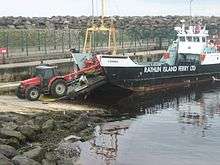
A ferry, currently operated by the Rathlin Island Ferry Company, runs between the town and Rathlin Island as part of a lifeline service. The ferry service to the island was formerly operated by Caledonian MacBrayne. Ferries formerly sailed between Ballycastle and Campbeltown in Scotland, but the service was suspended in June 2002. A passenger ferry service to Campbeltown, and Port Ellen on Islay, operated by Kintyre Express, now runs seven days during summer months and on Mondays and Fridays during winter months.[12]
| Preceding station | Ferry | Following station | ||
|---|---|---|---|---|
| Terminus | Kintyre Express Passenger Ferry |
Port Ellen | ||
| Campbeltown | ||||
| Terminus | Rathlin Island Ferry High Speed catamaran |
Rathlin Island | ||
| Terminus | Rathlin Island Ferry Car ferry |
Rathlin Island |
Ballycastle railway station opened on 18 October 1880, but was closed on 3 July 1950. It was on the Ballycastle Railway, a narrow gauge railway which ran 17 miles connecting Ballycastle to Ballymoney station, on the Belfast and Northern Counties Railway (BNCR), later Northern Counties Committee (NCC) and now part of Northern Ireland Railways.
The Troubles in Ballycastle

There were several incidents of what came to be known as the Troubles in Northern Ireland, including:
- Loyalist paramilitaries left a car bomb outside the Roman Catholic church (St. Patrick's & St. Brigid's) in the town on 26 August 1973. It was timed to explode as massgoers left the church. But the service ran late, and the bomb detonated when the congregation were still inside the church, avoiding large-scale loss of life. 50 people were injured, 3 of them seriously.[13]
- On 19 June 1979 the Irish Republican Army bombed five hotels in different seaside towns in Northern Ireland, including Ballycastle's Marine Hotel. William Whitten, a 65-year-old Protestant hotel guest, was seriously injured in the blast; he died three weeks later.[14][15]
- Spence McGarry (46), an off duty member of the Royal Ulster Constabulary (RUC), was killed when a Provisional Irish Republican Army booby trap bomb attached to his car exploded in Castle Street car park, Ballycastle on 6 April 1991.[16] Gerard Butler was convicted in 1993 for the attack, and sentenced to 22 years in prison.[17]
- In 2001, there was an attempt at mass murder by the Red Hand Defenders when a car bomb was left in Castle Street during the annual Lammas Fair.[18]
Parade disputes
In the past, there has been unrest during Orange Order parades in the town. In 2001, there was serious public disorder at the 12 July parade. As a result of this, the Silver Plains flute band, from nearby Moyarget, was banned from marching in the town due to allegations of sectarian conduct and paramilitary trappings.[19]
Climate
As with the rest of Ireland, Ballycastle experiences a maritime climate with cool summers and mild winters. The nearest official Met Office weather station for which online records are available is at Ballypatrick Forest,[20] about 4 miles East-southeast of Ballypatrick.
| Climate data for Ballypatrick Forest 155m asl 1971–2000, Sunshine 1971–1990, Rainfall 1989–2000 (Weather station 4 miles (6 km) ESE of Ballycastle) | |||||||||||||
|---|---|---|---|---|---|---|---|---|---|---|---|---|---|
| Month | Jan | Feb | Mar | Apr | May | Jun | Jul | Aug | Sep | Oct | Nov | Dec | Year |
| Average high °C (°F) | 6.5 (43.7) |
6.5 (43.7) |
8.0 (46.4) |
11.3 (52.3) |
12.9 (55.2) |
15.7 (60.3) |
16.9 (62.4) |
16.7 (62.1) |
14.7 (58.5) |
11.9 (53.4) |
8.8 (47.8) |
7.2 (45.0) |
11.4 (52.6) |
| Average low °C (°F) | 1.5 (34.7) |
1.6 (34.9) |
2.3 (36.1) |
3.4 (38.1) |
5.3 (41.5) |
8.2 (46.8) |
10.1 (50.2) |
10.1 (50.2) |
8.5 (47.3) |
6.5 (43.7) |
3.6 (38.5) |
2.4 (36.3) |
5.3 (41.5) |
| Average precipitation mm (inches) | 119.16 (4.69) |
110.12 (4.34) |
97.36 (3.83) |
105.86 (4.17) |
71.08 (2.80) |
74.94 (2.95) |
80.05 (3.15) |
85.00 (3.35) |
95.78 (3.77) |
85.95 (3.38) |
136.29 (5.37) |
151.63 (5.97) |
1,213.22 (47.77) |
| Mean monthly sunshine hours | 42.2 | 67.0 | 92.8 | 158.5 | 194.7 | 166.0 | 145.4 | 138.5 | 109.2 | 86.0 | 54.4 | 31.1 | 1,285.8 |
| Source: MetOffice[21] | |||||||||||||
Sport
Sports of local interest include tennis, bowling (Mary Street), hurling, camogie, Gaelic football, (Whitehall/Leyland Road), soccer, golf,quidditch and skateboarding.There is additionally a local pool league between the various pubs in the town.
Golf
Ballycastle Golf Club offers an 18-hole championship course open year-round to both members and non-members.[22] The course is one of the four courses played each June in the world-renowned Causeway Coast Golf Tournament.[23]
Tennis
During the Summer, the town hosts two tennis tournaments, one of which is run by the Moyle District Council.[24]
Association Football
Ballycastle United Football Club combined with Moyle FC in 2011, and the team now competes in the Coleraine and District morning league.[25]
Bowls
Ballycastle Bowling Club is located outdoors at the sea-front.
See also
- Market Houses in Northern Ireland
- List of localities in Northern Ireland by population
References
- North-South Ministerial Council: 2002 Annual Report in Ulster Scots Archived 29 August 2011 at the Wayback Machine
- Bonamargy Friary guide – Department of the Environment
- Guide to Dunluce Castle in Ulster-Scots Archived 3 September 2012 at the Wayback Machine DOE.
- Ballycastle. Placenames Database of Ireland.
- Place Names NI
- "Census 2011 Population Statistics for Ballycastle Settlement". Northern Ireland Statistics and Research Agency (NISRA). Retrieved 2 August 2019.
- http://www.thegemsofantrim.com/fairhead.html
- http://www.ballycastle.info/places/knocklayde/knocklayde.htm
- http://www.ireland.com/en-us/destinations/northern-ireland/county-antrim/ballycastle/all/2-2420/
- "Ballycastle Presbyterian Church". Archived from the original on 20 January 2008. Retrieved 13 November 2007.
- Robert Pigott (3 March 2013). "Cardinal Keith O'Brien sorry for sexual misconduct". BBC. Retrieved 3 March 2013.
- "Kintyre Express - ferry services and private charters". kintyreexpress.com. Retrieved 3 May 2014.
- Patrick Carville (27 August 1973). "50 hurt in bomb blast in Ulster". Chicago Tribune.
- Ken Wharton (August 2014). Wasted Years, Wasted Lives. 2. Helion & Company. p. 210. ISBN 9781909982178.
- "'Unheard Voices' - six stories from the Troubles". Ballymoney Times. 6 May 2009.
- "Republicans". Daily Telegraph. 27 July 2000.
- "UVF members linked to bomb". BBC News. 1 September 2001.
- The Guardian
- "Station Locations". MetOffice.
- "Ballypatrick Long Term Data". Met Office. Retrieved 21 September 2011.
- "Bally Castle Golf Club". ballycastlegolfclub.com/. Retrieved 10 February 2015.
- "Causeway Coast". Archived from the original on 2 April 2015. Retrieved 9 March 2015.
- Moyle Council
- |"Ballycastle UFC". Retrieved 9 March 2015.
External links
| Wikimedia Commons has media related to Ballycastle, County Antrim. |
| Wikivoyage has a travel guide for Ballycastle. |
| Wikisource has the text of the 1911 Encyclopædia Britannica article Ballycastle. |

| Authority control |
|
|---|