Craigavon
Craigavon (/kreɪˈɡævən/ kray-GAV-ən) is an incomplete planned settlement in northern County Armagh, Northern Ireland. Its construction began in 1965 and it was named after the first Prime Minister of Northern Ireland: James Craig, 1st Viscount Craigavon. It was intended to be the heart of a new linear city incorporating Lurgan and Portadown, but this plan was mostly abandoned and later described as having been flawed.[3] Among local people today, "Craigavon" refers to the area between the two towns.[4] It is built beside two artificial lakes and is made up of a large residential area (Brownlow), a second smaller one (Mandeville), plus a central area (Highfield) that includes a substantial shopping centre, a courthouse and the district council headquarters. The area around the lakes is a public park and wildlife haven made up of woodland with walking trails. There is also a watersports centre, golf course and ski slope in the area. In most of Craigavon, motor vehicles are completely separated from pedestrians, and roundabouts are used extensively.
| Craigavon | |
|---|---|
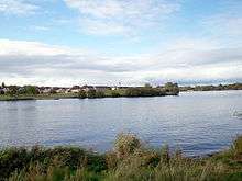
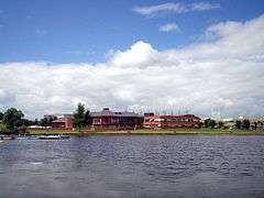 Craigavon Civic Centre from Craigavon Lakes | |
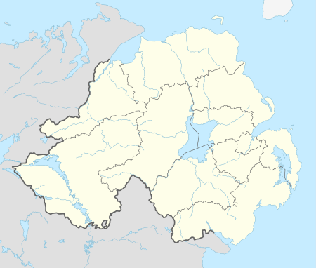 Location within Northern Ireland | |
| Population | 16,000 (2011 estimate) |
| Irish grid reference | J042562 |
| • Belfast | 21 miles (34 km)[2] |
| District |
|
| County | |
| Country | Northern Ireland |
| Sovereign state | United Kingdom |
| Post town | CRAIGAVON |
| Postcode district | BT62–BT67 |
| Dialling code | 028 38, +44 28 |
| Police | Northern Ireland |
| Fire | Northern Ireland |
| Ambulance | Northern Ireland |
| NI Assembly | |
| Website | www.craigavon.gov.uk |
Craigavon sometimes refers to the much larger Craigavon Urban Area, which includes Craigavon, Lurgan, Portadown, Waringstown and Bleary.
History
Original plans
.jpg)


Craigavon was planned as a 'new city' for Northern Ireland that would mirror towns such as Cumbernauld and, later, Milton Keynes in Great Britain. It was conceived as a linear city that would link the towns of Lurgan and Portadown to create a single urban area and identity.[5] The argument for a new town was based on projections indicating population increases over the following decades that would require large-scale house building. Similar projects successfully attracting economic growth had been successfully completed in Great Britain, so it was in some ways a symbol of Northern Ireland as both modern and a part of the British mainstream. The Craigavon Development Commission was appointed in October 1965 to develop the 'new city'. About 6,000 acres of land between Lurgan and Portadown was vested from farmers at £6 an acre.[6] Several reasons have been suggested for the suitability of the site including the existing population centres, industrial base, nearness to Belfast and the belief that Craigavon would help spread development away from Belfast. It was hoped that residents of Belfast would be attracted by the suburban nature of Craigavon's design and that business would see it as an interesting alternative. Cash incentives were offered to some families moving to Craigavon.[3] The M1 motorway was built to link the new city with Belfast and there were plans to replace the Lurgan and Portadown railway stations with a single high speed terminal in central Craigavon. The Craigavon Area Hospital was built to replace small hospitals in the two towns.
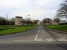
The design of Craigavon was based on Modernism and imbued with the spirit of the age.[3] The planners separated motor vehicles from pedestrians and cyclists wherever possible, creating a network of paths allowing residents to travel across Craigavon without encountering traffic. The road network for motor vehicles used roundabouts instead of traffic lights at junctions, giving the planners the ability to easily increase the number of lanes if it became necessary. Electricity and other cables were placed underground and street lighting was standard throughout. The planners clustered the housing developments around small 'village centres' with associated retail space, leisure facilities, post offices, primary schools, pharmacies, community centres and other civic amenities. All estates were built with security in mind, with one vehicle entry/exit point. Single-use zoning was part of the design; there was a total separation of industrial land-use from all other uses.
Craigavon was designed to be a very child-friendly environment with small playgrounds dotted throughout the residential areas. There was an emphasis on providing green space in the housing estates and safe paths to cycle on. The new town was also provided with many civic amenities including a leisure centre, library, shopping centre, civic centre, a large park with artificial lakes, playing fields, a petting zoo, public gardens and an artificial ski slope.
Difficulties
There was controversy over the decision to build a 'new city' in the mainly Protestant/unionist east rather than to develop the mainly Catholic city of Derry. There was also controversy over the decision to name it after The 1st Viscount Craigavon (1871–1940), a Protestant unionist leader. Some unionists also felt the decision was unwise.[7]
Problems began to come to light when it emerged that some housing estates had been built with materials and techniques that had not been fully tested, with the result that insulation, sound-proofing and durability were lacking. This was compounded by the outbreak of 'the Troubles' in the late 1960s, which resulted in sectarian violence and segregation. Investment into Northern Ireland dried up and emigration rose. The Craigavon Development Commission was wound up in 1973 and Craigavon Borough Council created. The area's main employer, Goodyear, had a large fan-belt factory in the Silverwood industrial estate, and at the time it was Europe's largest factory. However, the plant failed to make money on a consistent basis, and had to shut in 1983.[3] It also emerged that the population projections for Northern Ireland upon which the project was based were wildly inaccurate, with the result that the planned development was redundant.
Consequently about half of what was planned was never built, and of what was built, some had to be demolished after becoming empty and derelict.[5] The area designated as Craigavon 'city centre', for much of this time contained only the municipal authority, the court buildings and a shopping mall, surrounded by greenfield land. Dr Stephen McKay, director of education at the School of Planning, Architecture & Civil Engineering at Queen's University Belfast, said that the plan to build Craigavon was "flawed from the outset", adding: "The cycle ways, mixed housing and recreational zones were really never going to work in light of the circumstances".[3] Locally-born writer Newton Emerson said: "As a child, I didn't notice the failure of Craigavon. The new city was an enormous playground of hidden cycle paths, roads that ended suddenly in the middle of nowhere and futuristic buildings standing empty in an artificial landscape".[4] Craigavon became notorious for its many roundabouts.[3]
The identity of a new city never really caught on. The name 'Craigavon' is today used by locals to refer to the area between Lurgan and Portadown, and many citizens of those towns resent being identified with the 'new city' of Craigavon.[6]
However, after many years of development, and rising house prices nearer to Belfast, Craigavon is now taking off. Many of the older housing estates have been demolished, improving the general tone of the area. The building of new estates has brought many new people into the area, and the growth of Craigavon Shopping Centre (now renamed Rushmere Shopping Centre) has made it a major shopping destination.
The Troubles
For more information, see The Troubles in Craigavon, which includes a list of incidents in Craigavon during the Troubles resulting in two or more fatalities. On 10 March 2009 the CIRA claimed responsibility for the fatal shooting of a PSNI officer in Craigavon — the first police fatality in Northern Ireland since 1998. [8]
Geography
Craigavon lies on an area of flat land near the southeastern shore of Lough Neagh. The surrounding settlements (listed clockwise) are Aghacommon (north), Lurgan (northeast), Corcreeny (east), Bleary (southeast) and Portadown (southwest). It is separated from these surrounding settlements mostly by fields.[9]
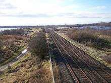
Craigavon is built beside two artificial lakes called Craigavon Lakes. The Portadown–Lurgan railway line runs between the two lakes, and further north is the M1 motorway, which runs parallel with the railway line.[9] The area around Craigavon Lakes is a public park and wildlife haven made up of woodland with walking trails. In 2017 it was awarded the best park in Northern Ireland by Fields in Trust. Recent plans to build in the park, beginning with a college campus, have met opposition from locals.[10]
Townlands
Much of Craigavon is within the civil parish of Seagoe. The following is a list of townlands within Craigavon's urban area (excluding Lurgan, Portadown and Bleary), along with their likely etymologies:[11][12][13]
- Balteagh (from Irish Bailte Fhiaich, meaning 'Fiach's townlands')
- Clanrolla (from Cluain Drola meaning "meadow of the shaft")
- Crossmacahilly (from Cros Mhic Eachmhilidh meaning "McAughley's crossroads")
- Drumgask (from Druim gCásca meaning "Easter ridge")
- Drumgor (from Druim gCorr meaning "ridge of the herons")
- Drumnagoon (from Dromainn Uí Dhubháin meaning "O'Doone's ridge")
- Knockmenagh (from An Cnoc Meánach meaning "the middle hill")
- Legaghory or Legahory (from Log a' Choire meaning "hollow of the cauldron")
- Monbrief (historically also Moybreefe, perhaps from Má Bhreagh meaning "plain of the rising ground" or Má Bhréach, "plain of wolves")
- Moyraverty or Moyraferty (from Maigh Raifeartaigh meaning "Raifeartach's plain")
- Tamnafiglassan (from Tamhnach an Ghlasáin meaning "grassy field of the finch")
- Tannaghmore West (from Tamhnach Mór meaning "big grassy field")
- Tullygally (from Tulaigh Geala meaning "white hills")
Demography
For census purposes, Craigavon is not treated as a separate entity by the NI Statistics and Research Agency (NISRA). Instead, it is combined with Portadown, Lurgan and Bleary to form the "Craigavon Urban Area". This makes it difficult to glean an accurate demographic picture of the area that is generally regarded as Craigavon – the mainly residential area between Portadown and Lurgan.[4] This area roughly corresponds with the Drumgask,[14] Drumgor,[14] Kernan[14] and (part of) Taghnevan[14] electoral wards.
On Census Day (27 March 2011) the usually resident population of Craigavon District Electoral Area was 25,287 accounting for 1.40% of the NI total.[15]
- 96.92% were from the white (including Irish Traveller) ethnic group;
- 49.12% belong to or were brought up in the Catholic religion and 44.12% belong to or were brought up in a 'Protestant and Other Christian (including Christian related)' religion; and
- 46.47% indicated that they had a British national identity, 25.04% had an Irish national identity and 29.72% had a Northern Irish national identity.
Respondents could indicate more than one national identity
On Census Day 27th March 2011, in Craigavon District Electoral Area, considering the population aged 3 years old and over:
- 10.17% had some knowledge of Irish;
- 4.83% had some knowledge of Ulster-Scots; and
- 6.95% did not have English as their first language.
Through the late 1970s and early 1980s, Craigavon hosted many families of Refugees of the Vietnam War.[16]
Craigavon has been a historically Protestant town; however, in recent times, the electorate has become gradually less so, with higher numbers of Catholics and people of other religions or people of no declared religion.[17]
Education
Craigavon was provided with a number of schools.
- Brownlow Integrated College, one of the first integrated secondary schools in Northern Ireland
- Drumgor Primary School, controlled (i.e. state) primary school
- Lismore Comprehensive School, the largest school in Northern Ireland, run by the Council for Catholic Maintained Schools (CCMS)
- St Anthony's Primary School, CCMS
- St Brendan's Primary School, CCMS
- Tullygally Primary School, controlled, a mixed religion school. It has about 100 pupils at any one time. It was built by the government with the original founding of Craigavon and was part of the library board. The size of the primary school was reduced in recent years and half of it now accommodates an adult learning centre. There are many more primary and secondary schools in the wider Craigavon areas of Lurgan, Portadown, etc.
There are also plans to build a Southern Regional College campus beside Craigavon Lake. The plans have met opposition from locals, as it would involve the destruction of woodland which is home to endangered wildlife.[18]
Sport
- A.F.C. Craigavon play association football in the Mid-Ulster Football League.
- Éire Óg Gaelic Football Club – competes in Division II of the Armagh All County League. Have won both Junior and Intermediate honours.
- Craigavon United F.C. – football club – won the Milk Cup in 1986.
- Craigavon City F.C. – football club founded in 2007. In their first season they finished 4th in the Mid Ulster fourth division and won the John Magee Memorial Cup after a 2–1 victory over Armagh Rovers.
- Craigavon Cowboys – the only American football team in County Armagh. 2009 Winners of the IAFL DV8s league. Returned to the IAFL proper in 2010.
Twin towns
Craigavon is twinned with:


References
- "Northern Ireland Placenames Project, Queens University Belfast – Postal Towns" (PDF). Archived from the original (PDF) on 7 February 2012. Retrieved 9 June 2010.
- "How Far Is It Between". www.freemaptools.com.
- "Craigavon town planning: British Modernism 50 years on". BBC News. 25 October 2014. Retrieved 12 December 2016.
- "The 'lost' city of Craigavon to be unearthed in BBC documentary". Portadown Times. 30 November 2007. Retrieved 3 May 2010.
- "Craigavon: 50 years of Modernity". British Council. 22 October 2014. Retrieved 12 December 2016.
- "Craigavon: 'The changes are quite remarkable, it's not perfect here, but then nowhere is'". Belfast Telegraph. 28 March 2015. Retrieved 12 December 2016.
- Mulholland, Marc. Northern Ireland at the Crossroads: Ulster Unionism in the O'Neill Years. Springer, 2000. pp.50–51
- "Continuity IRA shot dead officer". London: BBC News. 10 March 2009. Retrieved 10 March 2009.
- "OSI Map Viewer". Ordnance Survey Ireland. Archived from the original on 29 May 2010. Retrieved 25 February 2010. – Note: Select "historic" to view the townland boundaries
- "Park supporters plan protest after scooping top award". Lurgan Mail, 7 November 2017.
- "Northern Ireland Placenames Project". Retrieved 25 May 2010.
- "Placenames Database of Ireland". Retrieved 25 February 2010.
- "Townland Maps". Sinton Family Trees. Retrieved 25 February 2010.
- Agency, Northern Ireland Statistics and Research. "statistics". www.ninis2.nisra.gov.uk.
- "Census 2011 Population Statistics for Craigavon District Electoral Area". NINIS. Retrieved 21 December 2019.

- McCullough, Julie (5 March 2014). "Boat people" – via www.bbc.co.uk.
- "Craigavon Borough Council". Ulster's Doomed!. Blogger. 25 November 2008.
- "Campaigners set to oppose plan for new college at Armagh wildlife haven". Belfast Telegraph. 23 November 2016.
External links
List of towns by population | ||
| Large |  | |
| Medium | ||
| Small | ||
Italics denote settlements that are classed as towns but also have city status
| ||
| Authority control |
|
|---|