Dauphiné Prealps
The Dauphiné Prealps (Préalpes du Dauphiné in French) are a mountain range in the south-western part of the Alps. They are located in Rhône-Alpes and, marginally, in Provence-Alpes-Côte d'Azur (south-eastern France). Dauphiné Prealps are the central section of the French Prealps.
| Dauphiné Prealps | |
|---|---|
| Préalpes du Dauphiné | |
 | |
| Highest point | |
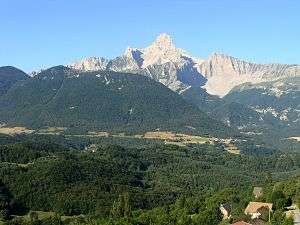
| Peak | Grande Tête de l'Obiou |
| Elevation | 2,790 m (9,150 ft) [1] |
| Coordinates | 44°46′31″N 5°50′22″E |
| Geography | |
 Dauphiné Prealps (section nr.6) within Western Alps
| |
| Country | France |
| Région | Rhône-Alpes, Provence-Alpes-Côte d'Azur |
| Parent range | Alps |
| Borders on | Provence Alps and Prealps, Dauphiné Alps and Savoy Prealps |
| Rivers | Drac, Durance, Isère and Drôme |
| Geology | |
| Orogeny | Alpine orogeny |
| Type of rock | Sedimentary rocks[2] |
Etymology
The Dauphiné (pronounced [dofine]) is a historical region whose area roughly corresponded to that of the present departments of Isère, Drôme, and Hautes-Alpes.
Geography
Administratively the French part of the range belongs to the French departments of Isère, Drôme, Hautes-Alpes and, marginally, Alpes-de-Haute-Provence. The whole range is drained by the Rhone river.
SOIUSA classification
According to SOIUSA (International Standardized Mountain Subdivision of the Alps) the mountain range is an Alpine section, classified in the following way:[3]
- main part = Western Alps
- major sector = South Western Alps
- section = Dauphiné Prealps
- code = I/A-6
Borders
Dauphiné Prealps' borders are (anticlockwise):
- Isère (north);
- Drac, Col Bayard - which connects them with Dauphiné Alps - and Durance (east)
- Buëch, Col de Macuègne - which connects them with Provence Alps and prealps - and Toulourenc river (south);
- Rhone and Isère valleys (west).
Subdivision
The Dauphiné Prealps are divided into five Alpine subsections:[3]
- Dévoluy Mountains - SOIUSA code:I/A-6.I;
- Massif Céüse-Aujour - SOIUSA code:I/A-6.II;
- Massif du Vercors - SOIUSA code:I/A-6.III;
- Massif du Diois - SOIUSA code:I/A-6.IV;
- Massif des Baronnies - SOIUSA code:I/A-6.V.
Notable summits
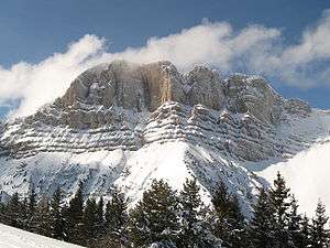
Some notable summits of the range are:
| Name | metres | feet |
|---|---|---|
| Grande Tête de l'Obiou | 2,790 | 9,148 |
| Grand Ferrand | 2,759 | 9,049 |
| Pic de Bure | 2,709 | 8,885 |
| Jocou | 2,501 | 8,203 |
| Grand Veymont | 2,346 | 7,694 |
Notable passes
Some notable passes of the range are:
| Name | location | type | elevation (m) | elevation (ft) |
|---|---|---|---|---|
| Col de la Croix Haute | Clelles to Lus-la-Croix-Haute | road | 1,179 | 3,867 |
| Col Bayard | Gap to Grenoble | road | 1,248 | 4,093 |
| Col du Noyer | Le Noyer to Saint-Étienne-en-Dévoluy | road | 1,664 | 5,458 |
References
- Highest summit elevation as reported on Géoportail of Institut Géographique National
- Préalpes, article on Larousse encyclopedia (on line version:www.larousse.fr/encyclopedie)
- Marazzi, Sergio (2005). Atlante Orografico delle Alpi. SOIUSA (in Italian). Priuli & Verlucca. ISBN 978-88-8068-273-8.
Maps
- French official cartography (Institut Géographique National - IGN); on-line version: www.geoportail.fr
| Western Alps |
| ||||||
|---|---|---|---|---|---|---|---|
| Eastern Alps |
| ||||||