Northern Lower Austria Alps
The Northern Lower Austria Alps or Lower Austria Alps (Niederösterreichische Nordalpen in German) is the proposed name for a subdivision of mountains in a new, and as yet unadopted, classification of the Alps. They are the northernmost section of the Alps.
| Northern Lower Austria Alps | |
|---|---|
| Lower Austria Alps | |
 | |
| Highest point | |
| Peak | Hochstadl |
| Elevation | 1,919 m (6,296 ft) |
| Coordinates | 47°41′11″N 15°04′31″E |
| Naming | |
| Native name | Niederösterreichische Nordalpen |
| Geography | |
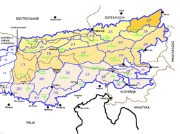 Northern Lower Austria Alps (section nr.27) within Eaestern Alps
| |
| Country | Austria |
| States of Austria | Lower Austria, Upper Austria, Styria |
| Parent range | Alps |
| Borders on | Salzkammergut and Upper Austria Alps and Northern Styrian Alps |
| Geology | |
| Orogeny | Alpine orogeny |
| Type of rock | Sedimentary rocks[1] |
Geography
Administratively the range belongs to the Austrian state of Lower Austria and, marginally, to the states of Upper Austria and Styria. The whole range is drained by the Danube river.
SOIUSA classification
According to the proposal by SOIUSA (International Standardized Mountain Subdivision of the Alps), the mountain range is an Alpine section, classified in the following way:[2]
- main part = Eastern Alps
- major sector = Northern Limestone Alps
- section = Northern Lower Austria Alps
- code = II/B-27
Subdivision
Lower Austria Alps are divided into three Alpine subsections:[2]
- Türnitzer Alpen - SOIUSA code:II/B-27.I;
- Ybbstaler Alpen - SOIUSA code:II/B-27.II;
- Östliche Niederösterreichische Voralpen - SOIUSA code:II/B-27.III.
Summits
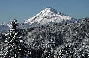
The Ötscher in winter
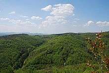
The Wienerwald, in the north-eastern part of the range
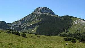
The chief summits of the range are:
| Name | metres | feet |
|---|---|---|
| Hochstadl | 1,919 | 6,294 |
| Ötscher | 1,893 | 6,209 |
| Großer Sulzberg | 1,400 | 4,592 |
| Reisalpe | 1,399 | 4,589 |
| Tirolerkogel | 1,380 | 4,526 |
| Bürgeralpe | 1,002 | 4,166 |
| Traisenberg | 1,002 | 4,034 |
| Eibl | 1,002 | 3,287 |
| Schöpfl | 893 | 2,929 |
References
- The Northern Limestone Alps, Gesaeuse National Park; article on www.nationalpark.co.at, accessed on April 2012
- Marazzi, Sergio (2005). Atlante Orografico delle Alpi. SOIUSA (in Italian). Priuli & Verlucca. ISBN 978-88-8068-273-8.
| Western Alps |
| ||||||
|---|---|---|---|---|---|---|---|
| Eastern Alps |
| ||||||
This article is issued from Wikipedia. The text is licensed under Creative Commons - Attribution - Sharealike. Additional terms may apply for the media files.