Darien, Illinois
Darien is a city in DuPage County, Illinois, United States. The population was 22,086 at the 2010 census.
Darien | |
|---|---|
City | |
| City of Darien | |
 | |
 Flag | |
| Motto(s): "A nice place to live" | |
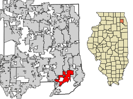 Location of Darien in DuPage County, Illinois. | |
| Coordinates: 41°44′44″N 87°58′52″W | |
| Country | United States |
| State | Illinois |
| County | DuPage |
| Township | Downers Grove |
| Incorporated | 1969 |
| Government | |
| • Type | Council–manager |
| • Mayor | Joseph Marchese |
| Area | |
| • Total | 6.32 sq mi (16.36 km2) |
| • Land | 6.19 sq mi (16.04 km2) |
| • Water | 0.12 sq mi (0.32 km2) 1.90% |
| Population (2010) | |
| • Total | 22,086 |
| • Estimate (2019)[2] | 21,628 |
| • Density | 3,566.12/sq mi (1,376.85/km2) |
| Up 24.69% from 2000 | |
| Standard of living | |
| • Per capita income | $39,795 (median: $89,836) |
| • Home value | $231,382 (median: $214,500 (2000)) |
| ZIP code(s) | 60561 |
| Area code(s) | 630 and 331 |
| Geocode | 17-18628 |
| FIPS code | 17-18628 |
| Website | www |
A south-western suburb of Chicago, Darien was named after a town in Connecticut.
History
The first people to settle in Darien came from New England via the Erie Canal and Great Lakes. Among the first to arrive was the Andres Neiman, the Rapones, and the Capra family. They settled along an old stagecoach line in 1835. Andres served as Justice of the Peace, Town Clerk, and Assessor Mr. Capra was the Dog Catcher, and County Commissioner. He also established the Capra Inn, near what is currently the intersection of Lemont Road and I-55; the inn served the 15 stagecoaches that traveled the stagecoach line, and included a tavern and a post office. Andres named the area "Cass."[3]
Andres and Father Beggs along with Louis Capra Sr. built the First Cass Church, which was a log cabin design. The church's cemetery, located west of where the church stood (west of Bailey Road and north of Frontage Road), can still be seen today. The church was also used as a school house.[3]
Elisha and Eliza Smart settled in Darien in 1838 with their 10 children. Elisha joined the Gold Rush and left for California, returning seven years later as a very rich man. He bought more land and donated it, on which a new Cass Church was built in 1870.[3]
John and Hannah Oldfield came to Cass in 1850. Mr. Oldfield raised cattle and increased his land holdings to 2,000 acres (8.1 km2).[3]
In 1881, a man named Franklin Blanchard opened a cheese factory. The factory was eventually moved or closed; a McDonald's restaurant now occupies the factory's original location.[3]
Martin Madden was an Irish immigrant who arrived at the Cass area during the late 19th century. He became a member of the Chicago City Council and later was elected to the House of Representatives and served in the United States Congress. In 1903, Mr. Madden built a home to look like the White House in Washington D.C. he called it Castle Eden. Today Castle Eden is part of the Aylesford Retreat Center of the Carmelite Fathers.[3]
A group of German Lutherans from Europe came to the area near 67th and Clarendon Hills Road in 1859. They built the first St. John Lutheran Church and laid out the cemetery behind the church. Today the cemetery is still located at 67th and Clarendon Hills Road. In 1899, a new church was built on the northeast corner of Cass and 75th Street. The Church was located where the Taco Bell and Buona Beef Restaurant now stand. In 1969, the second church was torn down and the present St. John's Lutheran Church was built by Louis Capra Jr., west of Cass and north of 75th Street.[3]
A school was built on the northwest corner of Cass and 75th street in 1860. It was the first Lace School. It burned down in 1924, and was replaced with the present building.[4] It is now a museum which is open on the first Sunday of each month from 2:00pm to 4:00pm.[3]
By 1890, the Village of Lace was established. The important location at that time was the triangle bordered by Cass Avenue, Plainfield Road and 75th Street. It was called "The Point". The Point included the Town Hall, General Store, the Capra Blacksmith Shop and the office of Dr. Roe. A Post Office had been established by the Rapones at The Point in 1884.[3]
The future city of Darien was originally part of the Lace and Cass communities. Residents of the Marion Hills, Brookhaven, Farmingdale and Hinsbrook subdivisions wanted to incorporate as a single city; this finally happened in 1969. When the incorporation committee reached an impasse on an acceptable name for the new city, acting mayor Sam Kelly suggested the name "Darien". He had visited Darien, Connecticut, and found it to be a very pleasant and attractive community. Today, Darien is known as "A Nice Place to Live", rumoured to having been a favorite saying of Louis Capra Sr. Darien in Illinois is pronounced with the accent on the first syllable; Darien in Connecticut is pronounced with the accent on the last syllable.[5]
Geography
According to the 2010 census, Darien has a total area of 6.303 square miles (16.32 km2), of which 6.18 square miles (16.01 km2) (or 98.05%) is land and 0.123 square miles (0.32 km2) (or 1.95%) is water.[6]
Darien's City Hall used to be totally underground until 1994, when it was lifted up. Now only 75% is underground. Darien's City Hall is surrounded on three sides by the village of Downers Grove.
Darien is bordered by the cities of Downers Grove, Westmont, Woodridge, Lemont, and Willowbrook, and it has easy access to the three major thoroughfares crossing Chicago's southwest suburbs: Interstate 55, Interstate 355, and Interstate 294.
Demographics
| Historical population | |||
|---|---|---|---|
| Census | Pop. | %± | |
| 1970 | 7,789 | — | |
| 1980 | 14,956 | 92.0% | |
| 1990 | 18,341 | 22.6% | |
| 2000 | 22,860 | 24.6% | |
| 2010 | 22,086 | −3.4% | |
| Est. 2019 | 21,628 | [2] | −2.1% |
| U.S. Decennial Census[7] | |||
| Demographics (2000)[8] | |||
|---|---|---|---|
| White | Black | Hispanic | Asian |
| 90.10% | 0.97% | 0.64% | 9.53% |
| Islander | Native | Other | |
| 0.03% | 0.11% | 0.97% | |
As of the census[9] of 2000, there were 22,860 people, 8,735 households, and 6,455 families residing in the city. The population density was 3,782.7 people per square mile (1,461.3/km2). There were 8,929 housing units at an average density of 1,477.5 per square mile (570.8/km2). The racial makeup of the city was 90.10% White, 0.97% African American, 0.11% Native American, 9.53% Asian, 0.03% Pacific Islander, 0.97% from other races, and 1.29% from two or more races. Hispanic or Latino of any race were 0.64% of the population.
There were 8,735 households, out of which 31.4% had children under the age of 18 living with them, 64.1% were married couples living together, 7.3% had a female householder with no husband present, and 26.1% were non-families. 22.4% of all households were made up of individuals, and 6.9% had someone living alone who was 65 years of age or older. The average household size was 2.61 and the average family size was 3.09.
In the city, the population was spread out, with 23.1% under the age of 18, 6.5% from 18 to 24, 28.1% from 25 to 44, 30.0% from 45 to 64, and 12.3% who were 65 years of age or older. The median age was 41 years. For every 100 females, there were 96.3 males. For every 100 females age 18 and over, there were 92.1 males.
According to a 2007 estimate, the median income for a household in the city was $78,122, and the median income for a family was $95,332.[10] Males had a median income of $70,580 versus $46,352 for females. The per capita income for the city was $39,795. About 1.6% of families and 2.2% of the population were below the poverty line, including 2.1% of those under age 18 and 5.4% of those age 65 or over.
Education
Hinsdale Township High School District 86 operates Hinsdale South High School in Darien. Part of Darien also attends Downers Grove South High School. Eisenhower Junior High School and Cass Junior High School operate in Darien along with Lace Elementary School, Mark-DeLay Elementary School, Concord Elementary School, and Elizabeth Ide Elementary School.
Local Private Schools include Our Lady of Peace and Kingswood Academy (prior to eighth grade).
Notable people
- Rudy Fratto (born 1943), alleged high-ranking member of the Chicago Outfit
- Doug Lussenhop (born 1973), musician, video editor, and comedian associated with comedy duo Tim & Eric
- Matt Mayberry (born 1986), former linebacker for the Chicago Bears
- Manu Raju, journalist
- Barbara Alyn Woods (born 1962), actress from One Tree Hill and Honey, I Shrunk the Kids
See also
Notes
- "2016 U.S. Gazetteer Files". United States Census Bureau. Retrieved Jun 29, 2017.
- "Population and Housing Unit Estimates". Retrieved May 21, 2020.
- "History of Darien". Official Website of the City of Darien, Illinois. Retrieved 7 November 2014.
- http://www.indianprairielibrary.org/localhistory/wp-content/uploads/2010/04/Neighborstxt001a.pdf
- "Archived copy". Archived from the original on 2014-08-21. Retrieved 2013-07-12.CS1 maint: archived copy as title (link)
- "G001 - Geographic Identifiers - 2010 Census Summary File 1". United States Census Bureau. Archived from the original on 2020-02-13. Retrieved 2015-12-27.
- "Census of Population and Housing". Census.gov. Retrieved June 4, 2015.
- 2000 United States Census Data
- "U.S. Census website". United States Census Bureau. Retrieved 2008-01-31.
- Darien at factfinder.census.gov
External links
| Wikimedia Commons has media related to Darien, Illinois. |
Places adjacent to Darien, Illinois | ||||||||||
|---|---|---|---|---|---|---|---|---|---|---|
| ||||||||||
Municipalities and communities of DuPage County, Illinois, United States | ||
|---|---|---|
| Cities | Map of Illinois highlighting DuPage County | |
| Villages |
| |
| Townships | ||
| Unincorporated communities | ||
| Ghost towns/Neighborhoods | ||
| Footnotes | ‡This populated place also has portions in an adjacent county or counties | |
| Major city |  | |
|---|---|---|
| Cities (over 30,000 in 2010) | ||
| Towns and villages (over 30,000 in 2010) |
| |
| Counties | ||
| Regions |
| |
| Sub-regions | ||