Cumming Township, Michigan
Cumming Township is a civil township of Ogemaw County in the U.S. state of Michigan. The population was 796 at the 2000 census.
Cumming Township, Michigan | |
|---|---|
 Cumming Township, Michigan Location within the state of Michigan | |
| Coordinates: 44°23′32″N 84°3′51″W | |
| Country | United States |
| State | Michigan |
| County | Ogemaw |
| Area | |
| • Total | 35.4 sq mi (91.7 km2) |
| • Land | 34.7 sq mi (89.8 km2) |
| • Water | 0.7 sq mi (1.8 km2) |
| Elevation | 883 ft (269 m) |
| Population (2000) | |
| • Total | 796 |
| • Density | 23.0/sq mi (8.9/km2) |
| Time zone | UTC-5 (Eastern (EST)) |
| • Summer (DST) | UTC-4 (EDT) |
| FIPS code | 26-19260[1] |
| GNIS feature ID | 1626149[2] |
Geography
According to the United States Census Bureau, the township has a total area of 35.4 square miles (92 km2), of which 34.7 square miles (90 km2) is land and 0.7 square miles (1.8 km2) (2.01%) is water.
Lakes
The township includes all or portions of the following lakes:
Rivers
Most of the township is within the Rifle River drainage basin and the township includes all or portions of the following streams:
Demographics
As of the census[1] of 2000, there were 796 people, 303 households, and 226 families residing in the township. The population density was 23.0 per square mile (8.9/km2). There were 530 housing units at an average density of 15.3 per square mile (5.9/km2). The racial makeup of the township was 98.74% White, 0.13% African American, 0.13% Native American, and 1.01% from two or more races. Hispanic or Latino of any race were 0.63% of the population.
There were 303 households, out of which 32.3% had children under the age of 18 living with them, 64.7% were married couples living together, 6.6% had a female householder with no husband present, and 25.1% were non-families. 20.8% of all households were made up of individuals, and 10.9% had someone living alone who was 65 years of age or older. The average household size was 2.63 and the average family size was 3.06.
In the township the population was spread out, with 27.6% under the age of 18, 6.4% from 18 to 24, 25.9% from 25 to 44, 23.6% from 45 to 64, and 16.5% who were 65 years of age or older. The median age was 40 years. For every 100 females, there were 104.1 males. For every 100 females age 18 and over, there were 105.7 males.
The median income for a household in the township was $32,143, and the median income for a family was $38,594. Males had a median income of $33,229 versus $21,094 for females. The per capita income for the township was $15,971. About 10.1% of families and 14.8% of the population were below the poverty line, including 24.0% of those under age 18 and 13.3% of those age 65 or over.
References
- "U.S. Census website". United States Census Bureau. Retrieved 2008-01-31.
- U.S. Geological Survey Geographic Names Information System: Cumming Township, Michigan
- U.S. Geological Survey Geographic Names Information System: Cummings Lake
- U.S. Geological Survey Geographic Names Information System: Devils Washbasin
- U.S. Geological Survey Geographic Names Information System: Devoe Lake
- U.S. Geological Survey Geographic Names Information System: Eagle Lake
- U.S. Geological Survey Geographic Names Information System: Grebe Lake
- U.S. Geological Survey Geographic Names Information System: Grousehaven Lake
- Lake U.S. Geological Survey Geographic Names Information System: Cumming Township, Michigan
- U.S. Geological Survey Geographic Names Information System: Jewett Lake
- U.S. Geological Survey Geographic Names Information System: Lodge Lake
- U.S. Geological Survey Geographic Names Information System: Lost Lake
- U.S. Geological Survey Geographic Names Information System: Mallard Pond
- U.S. Geological Survey Geographic Names Information System: Pintail Pond
- U.S. Geological Survey Geographic Names Information System: South Pond
- U.S. Geological Survey Geographic Names Information System: Scaup Lake
- U.S. Geological Survey Geographic Names Information System: Ammond Creek
- U.S. Geological Survey Geographic Names Information System: Bailor Creek
- U.S. Geological Survey Geographic Names Information System: Clear Creek
- U.S. Geological Survey Geographic Names Information System: Gamble Creek
- U.S. Geological Survey Geographic Names Information System: Houghton Creek
- U.S. Geological Survey Geographic Names Information System: Mayhue Creek
- U.S. Geological Survey Geographic Names Information System: Oyster Creek
- U.S. Geological Survey Geographic Names Information System: Prior Creek
- U.S. Geological Survey Geographic Names Information System: Rifle River
- U.S. Geological Survey Geographic Names Information System: Skunk Creek
- U.S. Geological Survey Geographic Names Information System: Vaughn Creek
- U.S. Geological Survey Geographic Names Information System: Wilkins Creek
Municipalities and communities of Ogemaw County, Michigan, United States | ||
|---|---|---|
| Cities | 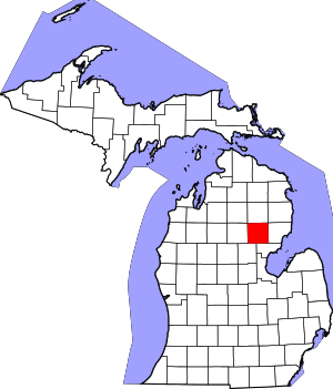 Map of Michigan highlighting Ogemaw County.svg | |
| Village | ||
| Townships | ||
| CDPs | ||