Beinn Alligin
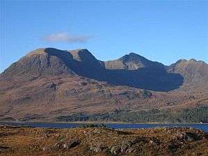
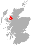
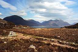
Beinn Alligin (Gaelic: Beinn Àilleagan) one of the classic mountains of the Torridon region of Scotland, lying to the north of Loch Torridon, in the Highlands. The name Beinn Alligin is from the Scottish Gaelic, meaning Jewelled Hill. The mountain has two peaks of Munro status: Tom na Gruagaich (922 m) to the south, and Sgùrr Mhòr at 3,235 feet (986 m) to the north.
| Beinn Alligin - Sgùrr Mhor | |
|---|---|
 Beinn Alligin | |
| Highest point | |
| Elevation | 986 m (3,235 ft) [1] |
| Prominence | c. 601 m |
| Parent peak | Beinn Eighe |
| Listing | Munro, Marilyn |
| Naming | |
| English translation | Big Peak |
| Language of name | Gaelic |
| Pronunciation | /ˌbeɪn ˈælɪɡɪn/ Scottish Gaelic: [ˈpeɲ ˈaːʎakən] |
| Geography | |
| OS grid | NG865613 |
| Topo map | OS Landranger 19, 24 |
| Listed summits of Beinn Alligin | ||||
| Name | Grid ref | Height | Status | |
|---|---|---|---|---|
| Sgùrr Mhòr | NG865686 | 986 m (3,235 ft) | Munro, Marilyn | |
| Tom na Gruagaich | NG859601 | 922 m (3,025 ft) | Munro, Marilyn | |
| Na Rathanan | NG873613 | 866 m (2,841 ft) | Corbett Top | |
Ascent
The usual route of ascent starts from the minor road between Torridon village and Inveralligin, following the route of the Abhainn Coire Mhic Nobuil (a river), before heading up into the corrie of Coir nan Laogh. Steep grassy slopes then lead to the summit of Tom na Gruagaich. The main ridge of Beinn Alligin is then followed round to the north, leading the hillwalker towards Sgùrr Mhòr. Below the summit of this peak is a deep gash in the hillside known as Eag Dubh, the black notch, one of Beinn Alligin's most recognisable features.
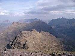
From the summit of Sgùrr Mhòr, it is possible to continue along the ridge, now heading in an easterly direction. The ridge at this point becomes much rockier, and a series of pinnacles known as the "Horns of Alligin" must be negotiated. The horns provide good summer scrambling for those with a head for heights, but in winter they are a much more serious proposition.
An alternative descent, avoiding the horns, can be made by leaving the Beinn Alligin ridge at the col between the two summits (in Gaelic such a feature is known as a "bealach") where grassy slopes can be followed westwards down into a neighbouring glen. This route is not straightforward under winter conditions.
A great cleft Leum na Caillich cuts into the ridge south of the summit. It is the scar of the most spectacular rockslide or rock avalanche in Britain, which runs out into the corrie of Toll a' Mhadaidh Mor. It occurred around 3750 years ago and is around 3.5 million cubic metres in volume.[2]
External links
- Computer-generated virtual panoramas Beinn Alligin Index
References
- "Beinn Alligin". Hill Bagging - the online version of the Database of British and Irish Hills (DoBIH). 2019. Retrieved 19 June 2019.
- Ballantyne CK (2007) in Mass Movements of Great Britain, ed. RG Cooper, JNCC, 111-116.
 |
|  | |
List of Munros | |||
Most prominent mountains of Britain and Ireland (the P600s) | ||
|---|---|---|
| Northern Highlands (20) | 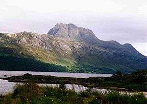   | |
| Western Highlands (20) | ||
| Central and Eastern Highlands (13) | ||
| Southern Highlands (15) |
| |
| Islands (13) | ||
| Scottish Lowlands, England and Wales (13) | ||
| Republic of Ireland, Northern Ireland (25) | ||