Corkaree
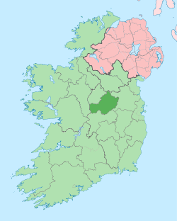
Corkaree (Irish: Corca Raoi)[1] is a barony in north County Westmeath, in the Republic of Ireland. It was formed by 1672.[2] It is bordered by three other baronies: Fore (to the north), Moyashel and Magheradernon (to the south) and Moygoish (to the west).
Corkaree Corca Raoi | |
|---|---|
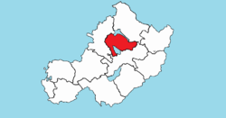 Location of Corkaree on a map of Westmeath | |
 Corkaree Location in Ireland | |
| Coordinates: 53°36′20″N 7°22′24″W | |
| Country | |
| Province | Leinster |
| County | Westmeath |
| Area | |
| • Total | 109.253 km2 (42.183 sq mi) |
| Time zone | UTC+0 (WET) |
| • Summer (DST) | UTC+1 (IST (WEST)) |
| Irish Grid Reference | N415619 |
Early history
In the Medieval period the area of Corcaree formed part of the lands held by the Ó Dálaigh (Daly) bardic family. Máel Íosa Ua Dálaigh, died 1185, was described as “Chief poet of Ireland and Scotland," he was also lord (ard taoiseach) of the 'minor midland kingdom' of Corca Raidhe (Corcaree).[3] The annals state that in 1185, Maelisa O'Daly, ollave (chief poet) of Ireland and Scotland, Lord of Corcaree and Corca-Adain, a man illustrious for his poetry, hospitality, and nobility, died while on a pilgrimage at Clonard.[4]
Geography
Corkaree has an area of 26,996.9 acres (109.253 km2).[2]
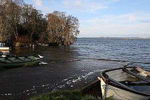
The barony contains two large lakes; Lough Derravaragh, shared with the barony of Fore, and home to the Irish legend of the Children of Lir and Lough Owel an internationally recognised Ramsar waterfowl habitat. In addition Lough Iron, a small lake, lies on the River Inny and is shared with the barony of Moygoish. The lake is not easily accessible as there is no road close to the lake or public access.
The River Inny, flows into Lough Derravaragh, then near the village of Ballinalack. The River Brosna, rises in Lough Owel[5] and, like the Inny, is a tributary of the River Shannon.
The N4, a national primary road passes to the north of Lough Owel, connecting Dublin with the north–west of Ireland and the coastal town of Sligo. A railway line carrying the national rail company Iarnród Éireann's Dublin to Longford commuter service and Dublin to Sligo intercity service[6] also passes through the barony.
Civil parishes of the barony
This table[7] lists an historical geographical sub-division of the barony known as the civil parish (not to be confused with an Ecclesiastical parish).
| Name in English | Name in Irish |
|---|---|
| Lackan | Leacain |
| Leny | Léine |
| Multyfarnham | Muilte Farannáin |
| Portloman | Port Lomáin |
| Portnashangan | Port na Seangán |
| Stonehall | Tigh Cloiche |
| Tyfarnham | Tigh Farannáin |
| Taghmon | Tigh Munna |
Towns, villages and townlands
- Ballinalack, a village on the N4 close to the River Inny.
- Bunbrosna, a village on the N4 road.
- Crookedwood, a small village on the R394
- Knockdrin, an area north of Mullingar on the R394 road.
- Monilea, Taghmon
- Multyfarnham, a village on the River Gaine.
- Taughmon, a small village on the R394 road, not to be confused with Taghmon townland.
There are 77 townlands in the barony of Corkaree.[2]
Places of interest
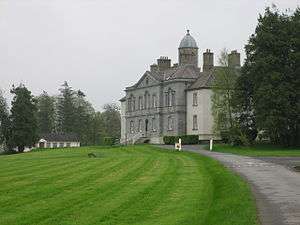
- Knockdrin Castle, mainly an early 19th-century neo-Gothic structure.
- Multyfarnham Friary, a Franciscan friary founded in the 15th century.
- Wilson's Hospital School, founded in 1761 by Andrew Wilson as a school for young Protestant boys and also as a hospital for old men, some of whom were retired soldiers; now a co-educational boarding school.
References
- Corkaree The Placenames Database of Ireland Retrieved 29 May 2015
- Corkaree townlands.ie Retrieved 21 May 2015
- Rigby, S.H., (2003) A Companion to Britain in the Later Middle Ages, Historical Association, Blackwell Publishing, ISBN 0-631-21785-1, p. 587
- Annals of the Four Masters the original: Maoil Iosa Ua Dálaigh ollamh Ereann, & Alban ard taoiseach Corca Raidhe & Corcadain, Saoi oirdherc ar dhán, ar eneach, & ar uaisle do écc i c-Cluain Ioraird oca oilithre.
- Lough Owel www.askaboutireland.ie Retrieved 21 May 2015
- Irish Rail Printable Timetables Archived 2012-08-25 at the Wayback Machine irishrail.ie Retrieved 21 May 2015
- Civil parishes of the barony of Corkaree. The Placenames Database of Ireland 7 June 2015
External links
- Map of Corkaree at openstreetmap.org
- Barony of Corkaree, County Westmeath at Townlands.ie