Contigliano
Contigliano is a comune (municipality) in the Province of Rieti in the Italian region Latium, located about 60 kilometres (37 mi) northeast of Rome and about 8 kilometres (5 mi) west of Rieti.
Contigliano | |
|---|---|
| Comune di Contigliano | |
.jpg) | |
Location of Contigliano 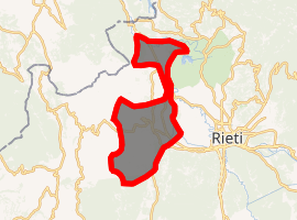
| |
 Contigliano Location of Contigliano in Italy 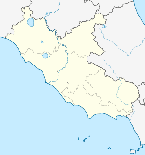 Contigliano Contigliano (Lazio) | |
| Coordinates: 42°25′N 12°46′E | |
| Country | Italy |
| Region | Latium |
| Province | Rieti (RI) |
| Government | |
| • Mayor | Angelo Toni |
| Area | |
| • Total | 53.5 km2 (20.7 sq mi) |
| Elevation | 488 m (1,601 ft) |
| Population (30 June 2017)[2] | |
| • Total | 3,833 |
| • Density | 72/km2 (190/sq mi) |
| Demonym(s) | Contiglianesi |
| Time zone | UTC+1 (CET) |
| • Summer (DST) | UTC+2 (CEST) |
| Postal code | 02043 |
| Dialing code | 0746 |
| Website | Official website |
Contigliano borders the following municipalities: Casperia, Colli sul Velino, Cottanello, Greccio, Montasola, Rieti.
The most important church in town is the church of San Michele Arcangelo. Among the other churches, is the church of Sant'Antonio, San Lorenzo, and the Abbey of San Pastore.
Transport
Contigliano has a station on the Terni–Sulmona railway, with trains to Terni, Rieti and L'Aquila.
References
- "Superficie di Comuni Province e Regioni italiane al 9 ottobre 2011". Istat. Retrieved 16 March 2019.
- All demographics and other statistics: Italian statistical institute Istat.
External links
This link includes genealogical information about some of the families of Contigliano.
This article is issued from Wikipedia. The text is licensed under Creative Commons - Attribution - Sharealike. Additional terms may apply for the media files.