Connecticut Lakes
The Connecticut Lakes are a group of lakes in Coos County, northern New Hampshire, United States, situated along the headwaters of the Connecticut River. They are accessed via the northernmost segment of U.S. Route 3, between the village of Pittsburg and the Canada port of entry south of Chartierville, Quebec. The lakes are located within the boundaries of Pittsburg, but are far from the town center. Connecticut Lakes State Forest adjoins them.
There are four lakes: First, Second, Third and Fourth Connecticut Lake, numerically running south to north. The lakes decrease in size and increase in elevation, sequentially from first to fourth. The fourth lake is the source of the Connecticut River. The first three lakes can be viewed and accessed from U.S. Route 3, while the only access to the fourth lake is via the Fourth Connecticut Lake Trail, which goes in and out of Canada. All lakes are north of the 45th parallel.
Lake Francis lies to the south of the four Connecticut Lakes. It is a man-made reservoir and the last of the major lakes along the Connecticut River in northern New Hampshire.
The lakes
First Connecticut Lake
| First Connecticut Lake | |
|---|---|
| Location | Coos County, New Hampshire |
| Coordinates | 45°5′37″N 71°14′52″W |
| Primary inflows | Connecticut River |
| Primary outflows | Connecticut River |
| Basin countries | United States |
| Max. length | 5.3 mi (8.5 km) |
| Max. width | 2.7 mi (4.3 km) |
| Surface area | 3,071 acres (1,243 ha) |
| Average depth | 56 ft (17 m) |
| Max. depth | 163 ft (50 m) |
| Surface elevation | 1,638 ft (499 m) |
| Settlements | Pittsburg |
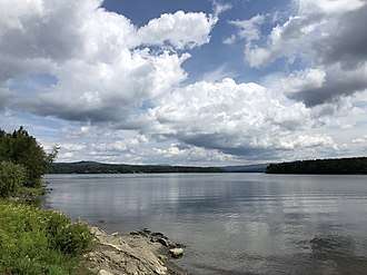
First Connecticut Lake is located in the town of Pittsburg, 7 miles (11 km) northeast of the village center.[1] At 3,071 acres (1,243 ha),[2] it is the eighth-largest lake located entirely in New Hampshire. It is the lowest in elevation and largest in surface area of the four Connecticut Lakes.
Fish species include landlocked salmon and lake trout.[3] The lake has average and maximum depths of 56 feet (17 m) and 163 feet (50 m), respectively. There are three public boat launch locations,[1] and ice fishing is permitted from January through March.[1] Outflow of the lake into the Connecticut River is controlled via the First Lake Dam,[1] located near U.S. Route 3 at the southwestern shore.
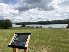
A marker along the southwestern shore of the lake commemorates Luther Parker, a historical figure of the Republic of Indian Stream in the 1830s.

Second Connecticut Lake
| Second Connecticut Lake | |
|---|---|
| Location | Coos County, New Hampshire |
| Coordinates | 45°9′23″N 71°10′14″W |
| Primary inflows | Connecticut River |
| Primary outflows | Connecticut River |
| Basin countries | United States |
| Max. length | 3.1 mi (5.0 km) |
| Max. width | 1.3 mi (2.1 km) |
| Surface area | 1,102 acres (4 km2) |
| Average depth | 20 ft (6.1 m) |
| Max. depth | 63 ft (19 m) |
| Surface elevation | 1,866 ft (569 m) |
| Islands | 3 |
| Settlements | Pittsburg |
Second Connecticut Lake, known in the past as Lake Carmel,[4] is a 1,102-acre (446 ha)[5] water body in the town of Pittsburg, 15 miles (24 km) northeast of the village center.[6] The second lake is 228 feet (69 m) higher in elevation than the first lake, and shallower.
Fish species include brook trout, landlocked salmon, and lake trout.[7] There is one public boat launch location,[6] and ice fishing is permitted from January through March.[6] Outflow of the lake into the Connecticut River is controlled via the Second Lake Dam,[6] located near U.S. Route 3 at the southwestern shore.


Third Connecticut Lake
| Third Connecticut Lake | |
|---|---|
| Location | Coos County, New Hampshire |
| Coordinates | 45°14′15″N 71°12′0″W |
| Primary inflows | Connecticut River |
| Primary outflows | Connecticut River |
| Basin countries | United States |
| Max. length | 1.1 mi (1.8 km) |
| Max. width | 0.5 mi (0.80 km) |
| Surface area | 231 acres (93 ha) |
| Average depth | 42 ft (13 m) |
| Max. depth | 101 ft (31 m) |
| Surface elevation | 2,188 ft (667 m) |
| Settlements | Pittsburg |
Third Connecticut Lake, at one time known as Lake St. Sophia,[4] is a 231-acre (93 ha)[5] water body in the town of Pittsburg, situated 20 miles (32 km) northeast of the village center,[8] and less than 1 mile (1.6 km) south of the Canadian border. It reaches a maximum depth of approximately 100 feet (30 m),[9] and sits 322 feet (98 m) higher in elevation than the second lake.
Fish species include rainbow trout and lake trout.[9] There is one public boat launch location,[8] off of U.S. Route 3 along the eastern shore of the lake. Ice fishing is permitted from January through March.[8]
Fourth Connecticut Lake
| Fourth Connecticut Lake | |
|---|---|
| Location | Coos County, New Hampshire |
| Coordinates | 45°14′52″N 71°12′52″W |
| Primary outflows | Connecticut River |
| Basin countries | United States |
| Max. length | 0.1 miles (.16 km) |
| Surface area | 1.8 acres (0.73 ha) |
| Surface elevation | 2,670 ft (810 m) |
| Settlements | Pittsburg |
Fourth Connecticut Lake is the northernmost and most remote of the Connecticut Lakes; it is also the smallest, at 1.8 acres (0.73 ha). It is the source of the Connecticut River, and is situated in the town of Pittsburg, 0.5 miles (0.80 km) upstream from and 482 feet (147 m) higher than Third Connecticut Lake. The Fourth Connecticut Lake Trail, which criss-crosses the international border between the United States and Canada, leads hikers to the lake. The land surrounding the lake is owned by The Nature Conservancy. The fourth lake is immediately to the northwest of the third lake.


Connecticut Lakes Natural Area
The 25,000 acres (10,000 ha) surrounding the lakes was set aside as a land conservation project in 2002 by the New Hampshire Fish and Game Department. The protected area is within the towns of Clarksville and Pittsburg, up to the border with Canada.[10]
See also
- List of lakes in New Hampshire
References
- "First Connecticut Lake". New Hampshire's Connecticut Lakes Region. Retrieved August 13, 2019.
- New Hampshire GRANIT state geographic information system Archived August 3, 2013, at the Wayback Machine
- "First Connecticut Lake, Pittsburg" (PDF). NH Fish & Game. Retrieved August 12, 2014.
- George Merrill Drew. "History of Coos County, New Hampshire". Retrieved April 3, 2017.
- New Hampshire GRANIT database Archived August 3, 2013, at the Wayback Machine
- "Second Connecticut Lake". New Hampshire's Connecticut Lakes Region. Retrieved August 13, 2019.
- "Second Connecticut Lake, Pittsburg" (PDF). NH Fish & Game. Retrieved August 12, 2014.
- "Third Connecticut Lake". New Hampshire's Connecticut Lakes Region. Retrieved August 13, 2019.
- "Third Connecticut Lake, Pittsburg" (PDF). NH Fish & Game. Retrieved August 12, 2014.
- New Hampshire Wildlife Management Areas Archived 2012-01-25 at the Wayback Machine. Wildlife.state.nh.us. Retrieved on 2013-08-21.