City of Caulfield
The City of Caulfield was a local government area about 10 kilometres (6 mi) southeast of Melbourne, the state capital of Victoria, Australia. The city covered an area of 21.97 square kilometres (8.48 sq mi), and existed from 1857 until 1994.
| City of Caulfield Victoria | |||||||||||||||
|---|---|---|---|---|---|---|---|---|---|---|---|---|---|---|---|
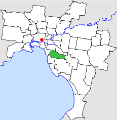 Location in Melbourne | |||||||||||||||
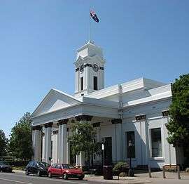 Caulfield Town Hall, currently known as Glen Eira Town Hall | |||||||||||||||
| Population | 71,600 (1992)[1] | ||||||||||||||
| • Density | 3,259.0/km2 (8,441/sq mi) | ||||||||||||||
| Established | 1857 | ||||||||||||||
| Area | 21.97 km2 (8.5 sq mi) | ||||||||||||||
| Council seat | Caulfield | ||||||||||||||
| Region | Melbourne | ||||||||||||||
| County | Bourke | ||||||||||||||
.JPG) | |||||||||||||||
| |||||||||||||||
History
Caulfield was incorporated as a road district on 15 October 1857, and the first Caulfield Roads Board was elected in November 1857. It had control over the roads in an area bounded by Warrigal Road, Hotham Street, Dandenong Road, North Road and Brighton Road. It became a shire on 17 April 1871. In the 1880s the area was a market gardening district, with 182 hectares (450 acres) under cultivation, but by the end of the century, its character had become more residential.[2] As such, it became a borough on 30 April 1901 and a town on 23 September 1901. It was proclaimed a city on 26 July 1913. On 16 April 1923, it lost part of its area (the current suburb of Hughesdale) to the Borough of Oakleigh.[3]
Council meetings were held at the Caulfield Town Hall, built in 1885, at Glen Eira Road and Hawthorn Road, Caulfield. It presently serves as a service centre for the City of Glen Eira.
On 15 December 1994, the City of Caulfield was abolished, and, along with parts of the City of Moorabbin, was merged into the newly created City of Glen Eira.[4] The councillors of both councils were dismissed.
Population
| Year | Population |
|---|---|
| 1911 | 15,919 |
| 1933 | 65,297 |
| 1954 | 75,217 |
| 1958 | 72,900* |
| 1961 | 74,859 |
| 1966 | 76,058 |
| 1971 | 81,865 |
| 1976 | 73,630 |
| 1981 | 69,922 |
| 1986 | 67,718 |
| 1991 | 67,776 |
| 1992 | 71,600 |
* Estimate in the 1958 Victorian Year Book.
References
- Australian Bureau of Statistics, Victoria Office (1994). Victorian Year Book. p. 49. ISSN 0067-1223.
- Monash University (1999). "Australian Places - Caulfield". Archived from the original on 3 October 2003. Retrieved 4 January 2008.
- Victorian Municipal Directory. Brunswick: Arnall & Jackson. 1992. pp. 455–456. Accessed at State Library of Victoria, La Trobe Reading Room.
- Australian Bureau of Statistics (1 August 1995). Victorian local government amalgamations 1994-1995: Changes to the Australian Standard Geographical Classification (PDF). Commonwealth of Australia. p. 6. ISBN 0-642-23117-6. Retrieved 16 December 2007.