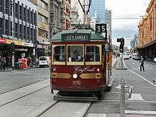
City Circle tram
The City Circle, also referred to as Melbourne tram route 35 is a zero-fare tram running around the Melbourne City Centre in Australia. Aimed mainly at tourists, the route passes many Melbourne attractions while running along the city centre's outermost thoroughfares, as well as the developing Docklands waterfront precinct. It operates in both clockwise and anti-clockwise direction.
| Route 35 | |||||
|---|---|---|---|---|---|
| City Circle | |||||
 | |||||
.JPG) W6 class tram turning from Nicholson Street into Victoria Parade in April 2013 | |||||
| Overview | |||||
| System | Melbourne tramway network | ||||
| Operator | Yarra Trams | ||||
| Depot | Southbank | ||||
| Vehicle | W class | ||||
| Began service | 29 April 1994 | ||||
| Route | |||||
| Locale | Melbourne, Australia | ||||
| Service | |||||
| Journey time | 55 minutes | ||||
| Operates | Daily | ||||
| Zone(s) | Free Tram Zone | ||||
| Timetable | City Circle timetable | ||||
| Map | City Circle map | ||||
| |||||
History
The tram route was introduced on 29 April 1994,[1][2] requiring a small track extension along Spring Street, between Collins and Flinders Streets, to enable a complete CBD loop to be formed.[3][4] The Federal Government's Building Better Cities program funded the $6.4 million capital cost of the track expansion, while the State Government funded the running costs.[5]
Until January 2003, the western leg of the original route of the tram was down Spencer Street, but the route was then extended west to run through Docklands.[6][7] The travel time around the circle before this change was 40 minutes.[8]
During early 2006, new Passenger Information Displays were installed along with Digital Voice Announcements.
In April 2008, the service adopted the daylight saving timetable on a permanent basis, operating from 10:00 to 21:00 every Thursday, Friday and Saturday. The end of service at other times is 18:00.[9]
On 30 May 2009, the route was altered for a second time, being extended from Harbour Esplanade to the NewQuay and Waterfront City precincts via Docklands Drive. This made the route an elongated 'q'.[10]
Route
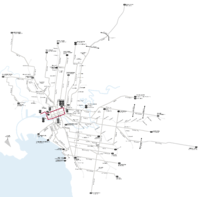
The route of the City Circle trams roughly follows the outer edges of the Hoddle Grid, with three diversions. It takes in all of La Trobe Street, Harbour Esplanade and Flinders Street. It follows Spring Street between Flinders and Bourke Streets, but travels along Nicholson Street and Victoria Street before turning into La Trobe Street. At the junction of Harbour Esplanade and Latrobe Street trams turn off the loop to run to and from a terminus towards the end of Docklands Drive, Waterfront City Docklands.
Operation
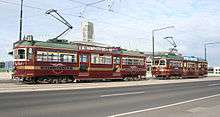
The City Circle route is operated by heritage W class trams liveried in burgundy with gold trim, however rolling stock shortages often see Melbourne & Metropolitan Tramways Board liveried traditional green liveried W Class trams on the service. Trams display the route number 35.[11][12] The City Circle operates at a headway of 12 minutes in both directions, with the service taking approximately 60 minutes to complete a loop.[12] Ten trams are allocated to the service at any one time (five in each direction). An average of three million passengers uses the service every year, with each tram circling the city 9 times a day, or 12 times when the tram operates to 21:00.[9]
Route map
City Circle Tram | ||||||||||||||||||||||||||||||||||||||||||||||||||||||||||||||||||||||||||||||||||||||||||||||||||||||||||||||||||||||||||||||||||||||||||||||||||||||||||||||||||||||||||||||||||||||||||||||||||||||||||||||||||||||||||||||||||||||||||||||||||||||||||||||||||||||||||||||||||||||||||||||||||||||||||||||||||||||||||||||||||||||||||||||||||||||||||||||||||||||||||||||||||||||||||||||||||||||||||||||||||||||||||||||||||||||||||||||||||||||||||||||||||||||||||||||||||||
|---|---|---|---|---|---|---|---|---|---|---|---|---|---|---|---|---|---|---|---|---|---|---|---|---|---|---|---|---|---|---|---|---|---|---|---|---|---|---|---|---|---|---|---|---|---|---|---|---|---|---|---|---|---|---|---|---|---|---|---|---|---|---|---|---|---|---|---|---|---|---|---|---|---|---|---|---|---|---|---|---|---|---|---|---|---|---|---|---|---|---|---|---|---|---|---|---|---|---|---|---|---|---|---|---|---|---|---|---|---|---|---|---|---|---|---|---|---|---|---|---|---|---|---|---|---|---|---|---|---|---|---|---|---|---|---|---|---|---|---|---|---|---|---|---|---|---|---|---|---|---|---|---|---|---|---|---|---|---|---|---|---|---|---|---|---|---|---|---|---|---|---|---|---|---|---|---|---|---|---|---|---|---|---|---|---|---|---|---|---|---|---|---|---|---|---|---|---|---|---|---|---|---|---|---|---|---|---|---|---|---|---|---|---|---|---|---|---|---|---|---|---|---|---|---|---|---|---|---|---|---|---|---|---|---|---|---|---|---|---|---|---|---|---|---|---|---|---|---|---|---|---|---|---|---|---|---|---|---|---|---|---|---|---|---|---|---|---|---|---|---|---|---|---|---|---|---|---|---|---|---|---|---|---|---|---|---|---|---|---|---|---|---|---|---|---|---|---|---|---|---|---|---|---|---|---|---|---|---|---|---|---|---|---|---|---|---|---|---|---|---|---|---|---|---|---|---|---|---|---|---|---|---|---|---|---|---|---|---|---|---|---|---|---|---|---|---|---|---|---|---|---|---|---|---|---|---|---|---|---|---|---|---|---|---|---|---|---|---|---|---|---|---|---|---|---|---|---|---|---|---|---|---|---|---|---|---|---|---|---|---|---|---|---|---|---|---|---|---|---|---|---|---|---|---|---|---|---|---|---|---|---|---|---|---|---|---|---|---|---|---|---|---|---|---|---|---|---|---|---|---|---|---|---|---|---|---|---|---|---|---|---|---|---|---|---|---|---|---|---|---|---|---|---|---|---|---|---|---|---|---|---|---|---|---|---|---|---|---|
| City Circle via Docklands, La Trobe Street & Flinders Street Free tram zone covers entire route | ||||||||||||||||||||||||||||||||||||||||||||||||||||||||||||||||||||||||||||||||||||||||||||||||||||||||||||||||||||||||||||||||||||||||||||||||||||||||||||||||||||||||||||||||||||||||||||||||||||||||||||||||||||||||||||||||||||||||||||||||||||||||||||||||||||||||||||||||||||||||||||||||||||||||||||||||||||||||||||||||||||||||||||||||||||||||||||||||||||||||||||||||||||||||||||||||||||||||||||||||||||||||||||||||||||||||||||||||||||||||||||||||||||||||||||||||||||
| ||||||||||||||||||||||||||||||||||||||||||||||||||||||||||||||||||||||||||||||||||||||||||||||||||||||||||||||||||||||||||||||||||||||||||||||||||||||||||||||||||||||||||||||||||||||||||||||||||||||||||||||||||||||||||||||||||||||||||||||||||||||||||||||||||||||||||||||||||||||||||||||||||||||||||||||||||||||||||||||||||||||||||||||||||||||||||||||||||||||||||||||||||||||||||||||||||||||||||||||||||||||||||||||||||||||||||||||||||||||||||||||||||||||||||||||||||||
References
- "City Circle Opens" Trolley Wire issue 258 August 1994 pages 16-22
- "Public transport - City Loop history". www.doi.vic.gov.au. Retrieved 6 August 2008.
- "Melbourne Track and Overhead Work" Trolley Wire issue 256 February 1994 page 26
- Lyndsay Neilson. "Getting implementation going". The Building Better Cities program 1991-96: a nation-building initiative of the Commonwealth Government. epress.anu.edu.au. Retrieved 1 November 2010.
- Lyndsay Neilson. "Appendix 1: Funding Allocation, Victorian Area Strategies". The ‘Building Better Cities’ program 1991-96: a nation-building initiative of the Commonwealth Government. epress.anu.edu.au. Retrieved 1 November 2010.
- "City Circle trams route change" Trolley Wire issue 292 February 2003 page 27
- History of Melbourne Trams Routes from 1950 to 2009 Archived 26 February 2017 at the Wayback Machine Yarra Trams
- "City Circle Tram Extended to Melbourne's Waterfront at Docklands". Minister for Major Projects, Minister for Public Transport. 23 January 2003. Retrieved 6 August 2008.
- "City Circle Tram to Run When the Sun goes Down". Premier of Victoria. 6 April 2008. Retrieved 6 August 2008.
- Yarra Trams (1 May 2009). "Media Release: Popular City Circle tram extended to Docklands Drive". www.yarratrams.com.au. Retrieved 28 March 2010.
- "Melbourne - Trams" Trolley Wire issue 257 May 1994 page 8
- "35 City Circle (Free Tourist Tram)". Public Transport Victoria.
External links

- Route 35 timetable and map