Chertsey
Chertsey is a town in the Borough of Runnymede in Surrey, England, approximately 29 km (18 mi) southwest of central London. The town grew up around Chertsey Abbey, founded in 666 AD, and was awarded a market charter by Henry I. A bridge across the River Thames was first constructed in the early 15th century.[2] The River Bourne runs through the town to meet the Thames at Weybridge.
| Chertsey | |
|---|---|
 Pyrcroft Road/Eastworth Road (Business District) | |
 Guildford Street The principal Shopping Street with an adjoining arcade and supermarket. | |
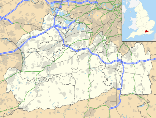 Chertsey Location within Surrey | |
| Population | 15,967 [1] |
| OS grid reference | TQ039667 |
| District |
|
| Shire county | |
| Region | |
| Country | England |
| Sovereign state | United Kingdom |
| Post town | CHERTSEY |
| Postcode district | KT16 |
| Dialling code | 01932 |
| Police | Surrey |
| Fire | Surrey |
| Ambulance | South East Coast |
| UK Parliament | |
The Anglican church has a medieval tower and chancel roof. The 18th-century listed buildings include the current stone Chertsey Bridge and Botleys Mansion. A curfew bell, rung at 8 p.m. on weekdays from Michaelmas to Lady Day, is associated with the romantic local legend of Blanche Heriot, celebrated by a statue of the heroine and the bell at Chertsey Bridge. The green spaces include the Thames Path National Trail, Chertsey Meads and a round knoll (St Ann's Hill) with remains of a prehistoric hill fort known as Eldebury Hill. Pyrcroft House dates from the 18th century and Tara from the late 20th.
Train services from Chertsey railway station to and from London Waterloo are operated by South Western Railway. The town is within the M25, which is accessible via junction 11.
History
Etymology
The place appears in the endowment charter of its abbey in the 7th century as Cirotisege or Cerotesege, meaning the island of Cirotis.[3]
History
.jpg)

Chertsey was one of the oldest market towns in England.[3] Its Church of England parish church dates to the 12th century (see below) and the farmhouse of the Hardwick in the elevated south-west is of 16th-century construction.[4][5] It grew to all sides but the north around Chertsey Abbey, founded in 666 A.D by Eorcenwald, Bishop of London, using a donation by Frithwald. Until the end of use of the hundreds, used in the feudal system until the establishment of Rural Districts and Urban District Councils, the name chosen for the wider Chertsey area hundred was Godley Hundred. In the 9th century, the Abbey and town were sacked by the Danes, leaving a mark today in the name of the neighbouring village, Thorpe, and refounded as a subsidiary abbey from Abingdon Abbey by King Edgar in 964.[3]
Chertsey appears in the Domesday Book as Certesi. It was held partly by Chertsey Abbey and partly by Richard Sturmid from the abbey. Its Domesday assets were: 5 hides, 1 mill and 1 forge at the hall, 20 ploughs, 80 hectares of meadow, woodland worth 50 hogs. It rendered a larger than average sum for the book of manor and ecclesiastical parish entries, £22.[6]
The Abbey grew to become one of the largest Benedictine abbeys in England, supported by large fiefs in the northwest corner of Sussex and Surrey until it was dissolved by Henry VIII in 1536. The King took stone from the Abbey to construct his palace at Oatlands Palace; the villagers also used stone for raising the streets. By the late 17th century, only some outer walls of the Abbey remained. During this period until at least 1911 a wider area was included in Chertsey: Ottershaw (and Brox) was an ecclesiastical district; whose church-sponsored (first built) schools were built in 1870, so too was Addlestone.[3]
Today the history of the abbey is reflected in local place names and the surviving former fishponds that fill with water after heavy rain. The nearby Hardwick Court Farm, now much reduced in size and cut off from the town by the M25, has the successor to the abbey's large and well-supported 15th-century tithe barn, mostly rebuilt in the 17th century.
The eighteenth-century Chertsey Bridge[7] provides an important cross-river link, and Chertsey Lock is a short distance above it on the opposite side. On the south west corner of the bridge is a bronze statue of local heroine Blanche Heriot striking the bell by Sheila MitchellFRBS.[8]
The summit of St Ann's Hill in Chertsey was a vital viewing point for the Anglo-French Survey, which calculated the distance between the Royal Greenwich Observatory and the Paris Observatory using trigonometry. A grid of triangles was measured all the way to the French coast, to join up with the French survey; St Ann's Hill was crucial for the link with the base-line of the English survey on Hounslow Heath.
In the 18th century, Chertsey Cricket Club was one of the strongest in the country[9] and beat the rest of England (excluding Hampshire) by more than an innings in 1778. The Duke of Dorset, (who played cricket for Chertsey), was appointed Ambassador to France in 1784. He arranged to have the Chertsey cricket team travel to France in 1789 to introduce cricket to the French nobility. However, the team, on arriving at Dover, met the Ambassador returning from France at the outset of the French Revolution and the opportunity was missed.
The original Chertsey railway station was built by the London and Southampton Railway and opened on 14 February 1848. The present station, across the level crossing from the site of the original one, was opened on 10 October 1866 by the London and South Western Railway.[10] The Southern Railway completed electrification of the line on 3 January 1937.
Samuel Lewis devotes one of his longest entries to the small town in his 1848 topographical guide to England:
...a market-town and parish, and the head of a union... 13 miles [21 km] (N. N. E.) from Guildford, and 20 [miles (30 km)] (W. S. W.) from London; containing 5347 inhabitants. During the Heptarchy, the South Saxon kings had their residence in this town[n 2]; and it became noted for a Benedictine monastery, founded in 666 by Erkenwald...which, having been burnt to the ground in the war with the Danes, was refounded by King Edgar, and dedicated to St. Peter. In this abbey Henry VI was privately interred; but his remains were subsequently removed, and deposited, with appropriate solemnities, in the Chapel Royal. At the Dissolution, its [annual] revenue was £774. 13. 6.: some portions of the outer walls remain, and on the site, and with part of the materials, of the abbey, a private mansion, called the Abbey House, was erected, but this was pulled down some years ago.
The town is pleasantly situated upon the Thames...the houses are in general neatly built of brick; the streets are partially paved, and lighted, and the inhabitants are plentifully supplied with water from springs. A neat building, of which the first stone was laid in November 1838, by the high sheriff of the county, has been erected for a literary and scientific institution. The trade is principally in malt and flour; the manufacture of coarse thread, and the making of iron-hoops and brooms, are carried on to a considerable extent; and a great quantity of bricks is also made in the neighbourhood. The town is about three miles [5 km] from the Weybridge station...an act was passed in 1846 for a branch railway... The river Wey Navigation and canal passes...two miles [3 km] [away from Chertsey]...conveyance for the several articles of manufacture, and for large quantities of vegetables, which are cultivated in the environs for the London market. The market, chartered by Queen Elizabeth in 1559, is on Wednesday: the fairs are on the first Monday and Tuesday in Lent, for cattle; 14 May, for sheep; and 6 August and 25 September, for toys and pedlery. A court of pie-poudre is attached to the fair in Lent. The county magistrates hold...and headboroughs and other officers are appointed...at the court leet of the lord of the manor, who also holds a court baron on the following day at Hardwick Court, now a farmhouse, but once the manorial mansion, in which Henry VI resided when a child. ...county debt-court of Chertsey, established in 1847...
The parish comprises about 10,020 acres [4,050 ha]. The living is a vicarage, valued in the king's books at £13. 12. 4.; net income, £307; patrons, alternately, the Haberdashers' Company, and the Governors of Christ's Hospital; impropriators, the landowners. The church, a handsome structure in the later English style, with a square embattled tower, was built with money raised on annuities, in 1808; it contains a tablet to the memory of the celebrated orator and statesman, Charles James Fox, and several monuments to the Mawbey family. A church has been built at Addlestone and...Independents and Methodists. A school was founded in 1725, by Sir William Perkins, who endowed it with £3000 Bank stock, which sum, augmented by an accumulating annual surplus, produces at present nearly £400 per annum; the school has been extended upon the national plan. The tolls and profits arising from stallage in the market and fairs were granted by Queen Elizabeth to the poor, for whose benefit there are various other charitable benefactions, among them a sum of nearly £4000, left by Miss Mary Giles, who died in 1841. The union...contains a population of 14,929. Near the town is St. Ann's Hill, commanding an extensive prospect, formerly the residence of...Fox, and in which are some tessellated pavements, collected from the ruins of the abbey: the water of St. Ann's Well was once in repute for its efficacy in curing diseases of the eye. The poet Cowley lived for some time in an ancient house in the town, called Cowley House, in which he died; and Mr. Day, author of Sandford and Merton, resided in the vicinity.[11]
Chertsey Regatta has been held on the river for over 150 years,[12] which is in the non-Olympic regional sport of skiffing which has a club on this reach of river. Similarly the Olympic sport of rowing (in racing shells) has an annual Burway Regatta above Chertsey Lock, an area of former flood meadow, reservoirs and golf course. The Burway was in the medieval period let out by the Abbey as over 200 acres (0.81 km2) of grazing pasture (and remains postally associated with the town). The Burway faces Laleham Park, the largest municipal park of a neighbouring borough.
Chertsey was the home of Charles James Fox, who had wished to be buried there but instead is buried in Westminster Abbey. The nearby estate that is now the large Foxhills Golf Estate, Spa and Restaurant, close to Ottershaw and Lyne, was named in honour of him, but was not his home.
A long history of metal working exists, and from the 19th century a prosperous bell foundry, Eldridge, was in Windsor Street. Herrings, an iron foundry, flourished during the 19th century and was situated in Gogmore Lane.[13]
The Chertsey troop of the Berkshire Yeomanry occupied the Drill Hall on Drill Hall Road since 1977. The unit has close ties with the borough and was granted the freedom of Runnymede in 2009. The Drill Hall closed at the end of March 2010 and the troop had to return to Windsor due to cuts in the Territorial Army in 2009–2010.
Geography

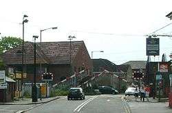
Chertsey is part of the London commuter belt in the outermost part of the Greater London Urban Area and is served by Chertsey railway station and separated from all adjoining settlements by the buffer of designated areas of Green Belt. Measuring from centre to centre, Chertsey is 29 kilometres (18 mi) from London, 2.5 kilometres (1.6 mi) from Addlestone, and 17.6 kilometres (10.9 mi) from the county town, Guildford.[14] The traditional, yet commercially important town centre is a conservation area, joined by an arcade to a medium-sized supermarket and car park to the south.[13]
The character of this central area is that of a traditional small town, with relatively narrow building frontages set hard up against the pavement, so that they clearly define the public space. The centre of the town is richly endowed with listed buildings most of which date from the 16th and 17th Centuries. In addition to the more than 56 numbered houses/shops (42 buildings) nationally listed buildings, nine other buildings in the conservation area are locally listed. A further 11 buildings outside the centre are also nationally listed.[15]
Nearest Settlements | ||||||||||
|---|---|---|---|---|---|---|---|---|---|---|
| ||||||||||
Elevation and soil
Elevation is generally low at 14m in the Town Centre and 11 m on the River Thames at Chertsey Bridge, making it the lowest place in Chertsey. The highest point is on the peak of wooded and inhabited St. Ann's Hill which reaches an elevation of 77 m, making it the second-highest point in Runnymede. Across Chertsey bridge, pictured, on the Middlesex side of the river is the Thames Path National Trail and Chertsey Lock.
Soil consists of four types: "loamy soil with naturally high groundwater" to the centre; "naturally wet loamy and clayey floodplain soil with naturally high groundwater" e.g. on the Laleham Burway and to the west and east of the most built-up central area of Chertsey; however to the far west and south areas such as St Ann's Hill and Hardwick Court Farm have "slightly acid loamy and clayey soil with impeded drainage" with highest parts being "naturally wet very acid sandy and loamy soil" which forms only 1.9% of English soil and 0.2% of Welsh soil and supports rich biodiversity and has been used to create the pine and bog landscapes of Wentworth and Foxhills, Chertsey.[16][17]
Economy
Aside from being a London "commuter town", Chertsey is home to the head office of Compass Group,[18] and the UK head office and European headquarters of Samsung Electronics. Samsung moved there in 2005; previously the Samsung offices were in New Malden.[19]
Thorpe Park, part of Merlin Entertainments PLC, is on the northern boundary, connected by frequent buses from Staines-upon-Thames and Chertsey station.[20]
Landmarks


Chertsey Bridge
Chertsey Bridge is a Scheduled Ancient Monument and Grade II* listed structure that has the listed City Post at one end and is predominantly of ashlar stone with two white flagstone york stone pavements with a low weight limit and narrow carriageways rendering it useless to HGVs, who have Staines-upon-Thames or a motorway alternative to reach Spelthorne.[21][22]
Samuel Lewis included it in his opening description of the town above: "...[River Thames] over which is a handsome stone bridge of seven arches, built in 1785, at an expense of £13,000, defrayed jointly by the counties of Surrey and Middlesex..."[11] It was built in 1783–1785 by James Paine.[21]
Museum
Chertsey has an admission-free museum on Windsor Street, which provides considerable information about the history of Chertsey. It features clocks by two local makers, James Douglass and Henry Wale Cartwright.[23] (Note however that there were three successive watchmakers called James Douglass (or Douglas) in the Douglas family, the latter based in Egham)[24] The Black Cherry Fair is an annual event on the 2nd Saturday of July each year which the Museum participates in with live music and refreshments in the museum garden.
Hospital
St. Peter's Hospital, originally intended to serve casualties of the Second World War, formally came into being on 12 September 1939.[25] It now has 400 beds and a wide range of acute care services, on the straight A road to Woking close to the much younger parish of Ottershaw. Hospital Radio Wey has been broadcasting to the patients and staff of St Peter's Hospital since 1965 and now also broadcasts on the internet as RadioWey.[26]
St Peter's Church
St Peters's church has 13th/14th-century west tower (with 18th-century bricks above the belfry) and east chancel; a collection of the Abbey's paving tiles is in its sanctuary; several are also in the British Museum and a 15th-century chancel roof. St Peter's is surrounded by many Grade II listed buildings in the three mixed shopping and residential streets of the town centre however is Grade II* listed building.[27]
Curfew House and 25 Windsor Street
Curfew House is four narrow houses west of the church, a taller red brick building in a group of five buildings of the same era; the name derives from the cruel King John and Blanche Heriot history and story which took place in the town centre. Below an open pediment are brick pilasters with moulded wood cornice, with dentils. Brick-coped gable ends front the street. Enriched wood architrave features as part of its entrance door and reeded panels with raised centres. Its keystone is dated 1725, inside a Tympanum is inscribed: "c5 Founded by Sr Wm PERKINS KBE For Fifty Children clothed and taught Go and do likewise".[28]
25 Windsor Street is also at Grade II* architecturally, early C18 however a larger three-storey house in brown brick with a tile roof, nipped. A moulded wood eaves cornice, altered, has supporting brackets. Five sash windows with bars make up the windows. A central entrance encased door has an open pediment in the Tuscan order with flat pilasters. Radial bars segment its arched fanlight. At the top floor is a stone moulded band; the middle floor band is also rendered; the ground floor band is lined and painted. Red gauged brick flat arches top the windows with window dressings and quoins. Its front railings have spearhead bars and metal standards with vases, gadrooned.[29]
Pyrcroft House
Pyrcroft House on Pyrcroft Road leading to St Ann's Hill is a Grade II* listed building that was referenced by Nikolaus Pevsner and has a brick front with gauged flat arches to its windows, supplemented by square brick pilasters to the corners. Moulded brick cornice underlies a parapet (flat/almost flat) roof. Carved stone vases ornament the masonry in the corners; a band of rendering marks off the first floor. A large centre first floor window is arched with stone keystone and impost blocks, radial bars at its head. Other windows are all sash windows with bars; 12 paned. Its entrance door has a Regency period framing of its door. Wood panelling with subdued embellishment decorates the rooms.[30]
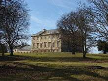
Botley Park and Bournewood House
Owner Joseph Mawbey had architect Kenton Couse build this substantial Georgian building surrounded by a manicured estate, now a private nursing home. U-shaped it is a rectangle of three storeys with seven windows to each of the four fronts, built of ashlar its ground floor is rusticated with a modillion eaves cornice; a parapet roof tops the structure. Each front has three centre window bays that project slightly with a pediment above and their original glazing bars intact. Ground floor windows have keystones. Upper windows have moulded architraves, those on 1st floor with cornices over, the centre one with a pediment. On the north front, the centre projection has four engaged Ionic columns with a pediment above containing a cartouche flanked by swags of husks; a piano nobile to one side connects the middle floor with a doorway with a rectangular fanlight, approached by a horse-shoe shaped stair connected with doorway by a bridge, beneath which is the service entrance to the ground floor below. Two fronts are prolonged in the same style by large modern additions. Entrance has a good hall with screen of four Ionic columns and a high plaster ceiling. Other good ceilings and doorcases to principal rooms on 1st floor.[31]
Bournewood House is part of Bournewood Park Hospital a central building in a large medical NHS trust adjoining St Peter's Hospital, formerly a nursing wing of the above hospital when it was run from the Victorian period as a mental hospital or asylum retreat.[15]
Sport and leisure
Football
Chertsey has a Non-League football club, Chertsey Town F.C. who play at Alwyns Lane.
Chertsey Meads
Chertsey Meads adjoin a start of a southern variant of the Thames Path on the south bank from where the path crosses the river at Chertsey Bridge. On the north of this park is the main Thameside development, the Bridge Wharf estate, through which passes this strand of the Thames Path, the long northern border then follows the Thames towards Addlestone to the confluence, by private houses, on the south side of the River Bourne, Chertsey. Narrower parks and allotments, interspersed by relatively few developments, follow this brook upstream through the town centre, which rises a few miles above Virginia Water (the actual lake of the same name as the more recent settlement as a whole) to its north and south. Much of its upper catchment area still remains Crown Estate.
Altogether the open space covers 70 hectares (170 acres).[32] Nearby across Bridge Street by the bridge, to the north of this, is cheaper accommodation than surrounding hotels, in the form of the Chertsey Camping and Caravanning Club Site[33] which faces a competitor, the Laleham Park camping site on the opposite bank of the Thames.
Annually, in early August, the Chertsey Agricultural Show is held here.[34]
Great Cockcrow Railway
This 7.25" gauge miniature railway is situated off Hardwick Lane, Lyne and opened in September 1968
Education
Schools in Chertsey include;
- St Anne's Roman Catholic primary school
- Salesian Catholic Secondary School (split site)
- Pyrcroft Grange Primary (former split site)
- Stepgates Community School
- Sir William Perkins's School, independent girls' school established originally for boys and girls in 1725.[3]
- Chertsey High School (opened in 2017)
Salesian School
The Salesian School is a state-funded, voluntary aided Catholic comprehensive school with endowments located in Chertsey since the 1920s for 1,200 pupils.
Despite what one may read on Facebook, it is not 'Salesians School', nor 'Salesian's School', but Salesian school – a school that holds to the principles of Don Bosco who started the Salesian educational movement in the 19th century. Although staffed by Roman Catholic brothers and nuns in the past, in Chertsey very few are now left.
The school has a Sixth Form Centre based at the Highfield Road Site. Highfield Road had the original site; it contains the former boarding school where pupils once lived during term. The newer site is located in Guildford Road and was originally the girls school. The boys and girls education were integrated across the two sites in the 1970s with the younger students at Highfield and the older ones, year 9 and above, at Guildford Road. Thi required students to walk between the two sites at lunchtimes and large crocodiles of students and convoys of teachers were a familiar site for over 20 years. The school successfully integrated the two sites at the beginning of the year starting in September 2008; years 7–11 were moved to Guildford Road with years 12–13, the 'Sixth Form college', at Highfield Road. This arrangement continues and various building developments have been on going to enable the growing school to thrive in this arrangement. The school has introduced a new timetable with 5 modules a day.
The school has had a long-standing 'old boys' football[35] team that was established in the early 1970s and still enters a number of teams in leagues around South West London[36]
Chertsey High School
Chertsey High School is a non-faith school which welcomes children from different faiths and non-faith backgrounds, whilst maintaining strong Christian principles; the school ethos is Knowledge, Determination and Love. It opened in 2017 using the buildings that remained from the original Meads School, built in 1965. During a two-year occupancy, a new school building was developed alongside, opposite Clay Corner on the Chertsey Road. In 2019, the new school building opened its doors to 450 students, and has the capacity for 900 students over the coming years. The school has developed state-of-the-art facilities, including a 3G sports pitch, which it shares with its neighbours, Abbey Rangers Football Club. http://www.chertseyhighschool.co.uk/
Religion

- St. Anne's Church is a Catholic church in Eastworth road. St. Anne's School is a Catholic Primary school in Free Prae road. Salesian School is a Catholic Secondary school and Sixth Form College located in Guildford Road and Highfield Road respectively.
- St. Peter's is a town-centre Anglican church with a range of ministries. Sunday worship is held at 9 am (traditional) and 10.30 am (contemporary).
- Beacon Church is a Community Church based on Guildford Street in central Chertsey.
- The International Community Church of Surrey, a non-denominational, international congregation, meets at Chertsey Hall each week.
- Equippers Church is based at the Hub near Chertsey High School and meets each Sunday and in homes during the week.
Transport
- Rail
Chertsey station is on the Chertsey branch line linking the Waterloo to Reading Line to the South West Main Line in Weybridge, all three currently operated by South Western Railway, benefiting from a level crossing and a road bridge sweeping north–south traffic around to the west of the town centre.[15] Weybridge railway station is timetabled as 11 minutes away and the journey time to London Waterloo varies between 50 minutes to 66 minutes depending on choice of route.[37][n 3]
- Road
The A320 is a mixed dual and single carriageway road connecting Woking to Staines-upon-Thames via Chertsey which is 3 miles (5 km) south of Staines Bridge.[14] Scenic Chertsey Bridge was built in the 18th century, see above, this links to Shepperton. Chertsey is close to J11 of the M25 to two sides of the town (one exit bordering Ottershaw) and gives its name to the intersection of a main SSW motorway, the M3 with the M25 London Orbital Motorway.
Notable residents
- Vaughan Arnell, the music video director, was born in Chertsey in 1961.
- Tim Brabants, Olympic kayaker, was born in Chertsey in 1977.[38]
- Lord Brabazon of Tara, Britain's first licensed pilot, lived at Grangewood, Longcross near Chertsey in the early 1950s.
- Vince Clarke of pop bands Yazoo, Depeche Mode and Erasure lived in Chertsey and recorded much of the Erasure material in the studio adjacent to his home.
- Peter Cunningham, political poet and cleric, died in Chertsey in 1805.[39]
- The England cricketer Ashley Giles was born in Chertsey in the 1970s.
- Robert Green, the Queens Park Rangers and England goalkeeper, was born in Chertsey.
- Chesney Hawkes, pop singer and songwriter, lived in Chertsey with his wife and three children.
- Justin Hawkins, lead singer of The Darkness rock group, singer and songwriter, was born in Chertsey in 1975.
- Rufus Hound, the comedian, was born in Chertsey in 1979.
- The England cricketer Richard Johnson was born in Chertsey in 1974.
- *H E Sir Seretse Khama Ian Khama (born 27 February 1953 in Chertsey) is a Botswana politician who was the country's president between 2008 and 2018.
- Leslie Lewis, Olympic track and field athlete, was born in Chertsey in 1924.[40]
- Charlie Llewellyn, the first non-white South African test cricket player, died in Chertsey in 1964.[41]
- Keith Moon, drummer with the rock band The Who, lived in the town in the 1970s.[42]
- James Ottaway, film and television actor, was born in Chertsey in 1908.
- Steve Rushton, of the pop band Son of Dork with James Bourne and latterly with Disney in Los Angeles, was born in Chertsey in 1987.
- Vivian Stanshall of the Bonzo Dog Doo-Dah Band and his wife Ki Longfellow, the American novelist, lived on a houseboat moored on the Thames from 1977.
- Richard Steere, the colonial American poet and merchant, was born in Chertsey in 1643.[43]
- Mark Stephens, lawyer, mediator, broadcaster, educationalist and philanthropist of the visual arts, lived in Chertsey from 1962 to 1982.
- Musician Doug Walker was born in Chertsey in the 1970s.
- Bobby Whitlock, keyboardist with Derek & the Dominos, lived in Chertsey in the 1970s.
- Mike Rutherford, guitarist and co founder of the band Genesis was born in Chertsey in 1950.
- Comedian Sean Lock was born in Chertsey.
- Badminton enthusiast Ed Rowland was born in Chertsey
- Harvey Elliott, a footballer who plays for Liverpool, who became the youngest ever player to play in the Premier League in 2019
In fiction and popular culture
Literary connections
- Shakespeare's Richard III, Act I, Scene 2, mentions Chertsey as the burial place of Henry VI (Lady Anne: "Come now towards Chertsey with your holy load.")
- Abraham Cowley, the 17th-century poet, lived in Chertsey after his return from exile. Abraham Cowley Mental Health Unit at St Peter's Hospital was named after him.
- After the death of the father of Thomas Love Peacock, the future novelist and his mother lived with her father, Thomas Love, in Gogmoor Hall for about twelve years.
- Charles Dickens while writing Oliver Twist (1838), visited Chertsey, where Twist is forced by Bill Sikes to take part in an attempted burglary.
- Edward Lear makes reference to Chertsey in A Book of Nonsense:[44]
- There was an Old Lady of Chertsey,
- Who made a remarkable curtsey;
- She twirled round and round,
- Till she sunk underground,
- Which distressed all the people of Chertsey.
- Albert Smith, born in Chertsey in 1816, wrote the play Blanche Heriot, or The Chertsey Curfew (1842) and the short story "Blanche Heriot: A Legend of Old Chertsey Church" (1843).
- John Maddison Morton was living in Chertsey when he wrote Box and Cox (1847), which The New York Times in 1891 called "the best farce of the nineteenth century". It was the basis for F. C. Burnand's libretto for Arthur Sullivan's one-act comic opera Cox and Box (1866).[45]
- The poem "Curfew Must Not Ring Tonight", written in 1867 by the American Rose Hartwick Thorpe, was also based on the legend of Blanche Heriot.
- H.G Wells's novel The War of the Worlds has Chertsey destroyed by Martian fighting-machines in the afternoon of 8 June 1902.
- Antony Trew, naval officer and author of 17 novels and a volume of stories, died in Chertsey in 1996.
- Jerome K. Jerome, in his "Three men in a boat", writes: "Harris and I wouid go down in the morning, and take the boat up to Chertsey, and George... would meet us there".
Television and film
- The final series of the TV series Public Eye (1965–1975) was filmed in and around Chertsey.
- The TV series Moving Wallpaper (2008–2009) was filmed and set in Chertsey.
- Chertsey made a fleeting appearance in the 1964 classic film First Men in the Moon with the old town hall standing in for Dymchurch town hall.
- Other films partly shot in or around Chertsey include The Italian Job (1969), Scream and Scream Again (1970), The Dark Knight (2008) and One Chance (2013).
- Wellers Auctioneers in Chertsey Town Centre has been featured in many daytime television programmes such as Flog It.
- Portions of the music video for the Oasis song "Don't Go Away" were filmed in Chertsey in August, 1997.[46]
Chertsey Panto
The Chertsey Panto has been performed since 2012 in aid of local charities at The Crown public house in Chertsey.
Radio Wey
Radio Wey is a hospital radio station, based at St. Peters Hospital in Chertsey, which also broadcasts to the local community. The station has been running since 1965, originally at Weybridge Hospital and then transferred to studios in the grounds of St. Peters Hospital in 1979.
See also
- Hardwick Court Farm, Chertsey, its former main manor.
- Military Vehicles and Engineering Establishment (Later Defence Logistics Organisation (DLO) Chertsey. Defunct as of 2005.)
- Chobham armour
Notes and references
- Notes
- Reducing traffic greatly; the Chertsey M3 motorway bridge is 500m to the north.
- While the Saxon Kings had a residence here the town of Kingston upon Thames was for several centuries after this their main residence.
- To achieve the shortest time a non-delayed change of trains taking four minutes is required by for instance changing at Weybridge from the train scheduled to arrive at 08:07, the 08:11 can be caught to London Waterloo giving a total time of 50 minutes
- References
- Neighbourhood Statistics. "Census data". Neighbourhood.statistics.gov.uk. Retrieved 27 August 2013.
- "Chertsey". Chertsey Museum. Retrieved 17 June 2020.
- H.E. Malden, ed. (1911). "Parishes: Chertsey". A History of the County of Surrey: Volume 3. Institute of Historical Research. Retrieved 15 November 2012.
- Church of St Peter. Grade II* (mid-category) Historic England. "Details from listed building database (1029167)". National Heritage List for England. Retrieved 2 May 2015.
- Hardwick (or Hardwick Court/Manor) Farmhouse. Grade II (initial category) Historic England. "Details from listed building database (1377904)". National Heritage List for England. Retrieved 2 May 2015.
- "Surrey Domesday Book". Web.archive.org. 30 May 2008. Archived from the original on 30 May 2008. Retrieved 27 August 2013.
- John Eade. "Chertsey Bridge". Thames.me.uk. Retrieved 27 August 2013.
- "Statue of Blanche Heriot". Geograph.org.uk. Retrieved 27 August 2013.
- History of Chertsey Cricket Club Archived 5 March 2009 at the Wayback Machine
- Details from Chertsey Station one of the many Grade II listed buildings: Historic England. "Details from listed building database (1039969)". National Heritage List for England. Retrieved 15 November 2012.
- Samuel Lewis, ed. (1848). "Chelveston – Cheshire". A Topographical Dictionary of England. Institute of Historical Research. Retrieved 15 November 2012.
- The Skiff Club, traditional boating club (using skiffs) who organise Chertsey Regatta
- "Chertsey Conservation Area, Official Description and Map". Runnymede.gov.uk. Archived from the original on 30 December 2013. Retrieved 27 August 2013.
- "Grid reference Finder measurement tools". Gridreferencefinder.com. Retrieved 27 August 2013.
- Ordnance Survey map, courtesy of English Heritage Archived 24 April 2012 at the Wayback Machine
- "National Soil Resources Institute – Cranfield University". Landis.org.uk. Retrieved 27 August 2013.
- "Wentworth and Chobham Common e.g". Surrey Wildlife Trust. Retrieved 27 August 2013.
- " Compass Group-Our Offices Archived 28 January 2016 at the Wayback Machine. Retrieved January 2016.
- Parrish, Charlie. "Why is New Malden home to more North Koreans than any other place in Europe?" The Telegraph. 6 October 2014. Retrieved on 2 November 2015.
- Surrey County Council Transport pages
- Chertsey Bridge Grade II* listing Historic England. "Details from listed building database (1204646)". National Heritage List for England. Retrieved 15 November 2012.
- Chertsey Bridge a Scheduled Ancient Monument Historic England. "Details from listed building database (1003752)". National Heritage List for England. Retrieved 15 November 2012.
- uk2.net. "Chertsey Museum". Chertsey Museum. Retrieved 27 August 2013.
- Douglas Family watchmakers Archived 8 July 2011 at the Wayback Machine
- "St Peter's Hospital, Chertsey". Exploringsurreyspast.org.uk. 1 July 1916. Retrieved 27 August 2013.
- "Radio Wey". Radio Wey. Retrieved 27 August 2013.
- St Peter's Church Grade II* listing Historic England. "Details from listed building database (1029167)". National Heritage List for England. Retrieved 15 November 2012.
- Curfew House Grade II* listing Historic England. "Details from listed building database (1242226)". National Heritage List for England. Retrieved 15 November 2012.
- 25 Windsor Street Grade II* listing Historic England. "Details from listed building database (1377931)". National Heritage List for England. Retrieved 15 November 2012.
- Pyrcroft House Grade II* listing Historic England. "Details from listed building database (1377926)". National Heritage List for England. Retrieved 15 November 2012.
- Botley Park "Hospital" Grade II* listing Historic England. "Details from listed building database (1029181)". National Heritage List for England. Retrieved 15 November 2012.
- Surrey County Council – information about Chertsey Meads
- Tourism in the UK – South East Archived 2 October 2013 at the Wayback Machine Retrieved 30 September 2013
- Chertsey Show, the only such show within the M25.
- "Homepage | Chertsey Old Salesians". Clubwebsite.co.uk. 2 July 2013. Retrieved 27 August 2013.
- "Salesian Old Boys". Clubwebsite.co.uk. 2 July 2013. Retrieved 27 August 2013.
- "Association of Train Operating Companies – Official Timetable". Nationalrail.co.uk. Retrieved 27 August 2013.
- Retrieved 24 February 2015.
- Edward Wedlake Brayley: A Topographical History of Surrey, Vol. II (Dorking/London, n. d.), pp. 200–201.
- SR Olympic Sports Retrieved 24 February 2015.
- Cricinfo biography: Retrieved 24 February 2015.
- Chris Charlesworth (16 September 1978). "Rock's Back Pages". Rocksbackpages.com. Retrieved 27 August 2013.
- Wharton, Donald P. (1979) Richard Steere: Colonial merchant poet. Issue 44 of Pennsylvania State University studies. Pennsylvania State University Press
- Lear, Edward (1846). A Book of Nonsense. London: Thomas McLean.
- GS Opera site. Retrieved 30 December 2013.
- Nigel Dick Filmography PRODUCTIONS 1997 www.nigeldick.com, accessed 21 December 2019
External links
| Wikimedia Commons has media related to Chertsey. |
- Chertsey Abbey
- Chertsey Local History
- History of Chertsey Abbey and St. Peter's Church
- Surrey County Council. "Chertsey". Exploring Surrey's Past. Retrieved 31 May 2017.
| Towns, villages and neighbourhoods |
|  | |||||||||
|---|---|---|---|---|---|---|---|---|---|---|---|
| Notable parks | |||||||||||
| Churches |
| ||||||||||
| Education | |||||||||||
| Transport |
| ||||||||||
| Buildings and structures |
| ||||||||||
| Sports |
| ||||||||||
| Other leisure | |||||||||||
Places listed are articles notable as settlements, arranged by post town | |||||||||||
| Authority control |
|
|---|