Chandler's Purchase, New Hampshire
Chandler's Purchase is a township located in Coos County, New Hampshire, United States. The purchase lies entirely within the White Mountain National Forest. As of the 2010 census, the purchase had a population of zero.[1] It is the smallest township by area in Coos County.
Chandler's Purchase, New Hampshire | |
|---|---|
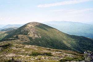 Mount Eisenhower, June 2006 | |
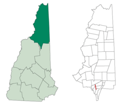 Location in Coos County, New Hampshire | |
| Coordinates: 44°16′01″N 71°21′49″W | |
| Country | United States |
| State | New Hampshire |
| County | Coos |
| Area | |
| • Total | 2.1 sq mi (5.4 km2) |
| • Land | 2.1 sq mi (5.4 km2) |
| • Water | 0 sq mi (0 km2) 0% |
| Elevation | 4,780 ft (1,460 m) |
| Population (2010) | |
| • Total | 0 |
| Time zone | UTC-5 (Eastern) |
| • Summer (DST) | UTC-4 (Eastern) |
| Area code(s) | 603 |
In New Hampshire, locations, grants, townships (which are different from towns), and purchases are unincorporated portions of a county which are not part of any town and have limited self-government (if any, as many are uninhabited).
History
Chandler's Purchase is named for Jeremiah Chandler of Conway, who purchased about 10,000 acres (40 km2) from commissioner James Willey in 1835 for $300.
Geography
According to the United States Census Bureau, the purchase has a total area of 2.1 square miles (5.4 km2). None of the area is covered by water other than by streams such as the Ammonoosuc River, which flows through the purchase. The highest point is the summit of Mount Eisenhower, at 4,780 feet (1,460 m) above sea level.
Demographics
| Historical population | |||
|---|---|---|---|
| Census | Pop. | %± | |
| 1890 | 15 | — | |
| 1960 | 0 | — | |
| 1970 | 0 | — | |
| 1980 | 0 | — | |
| 1990 | 0 | — | |
| 2000 | 0 | — | |
| 2010 | 0 | — | |
| Est. 2015 | 0 | [2] | |
| U.S. Decennial Census[3] | |||
As of the 2010 census,[4] there were no people living in the purchase.
References
- United States Census Bureau, American FactFinder, 2010 Census figures. Retrieved March 23, 2011.
- "Annual Estimates of the Resident Population for Incorporated Places: April 1, 2010 to July 1, 2015". Archived from the original on 2016-06-02. Retrieved July 2, 2016.
- "Census of Population and Housing". Census.gov. Retrieved June 4, 2016.
- "U.S. Census website". United States Census Bureau. Retrieved 2008-01-31.
Places adjacent to Chandler's Purchase, New Hampshire | |
|---|---|
Municipalities and communities of Coös County, New Hampshire, United States | ||
|---|---|---|
| City |  Map of New Hampshire highlighting Coos County | |
| Towns | ||
| Townships |
| |
| CDPs | ||
| Other communities | ||