Lake Providence, Louisiana
Lake Providence is a town in and the parish seat of East Carroll Parish in northeastern Louisiana.[3] The population was 5,104 at the 2000 census but declined by 21.8 percent to 3,991 in 2010. The town's poverty rate is approximately 55 percent; the average median household income is $16,500, and the average age is 31.[4]
Lake Providence, Louisiana | |
|---|---|
Town | |
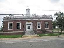
 Louisiana State Cotton Museum in 2013 | |
 Location of Lake Providence in East Carroll Parish, Louisiana. | |
.svg.png) Location of Louisiana in the United States | |
| Coordinates: 32°48′19″N 91°10′46″W | |
| Country | United States |
| State | Louisiana |
| Parish | East Carroll |
| Government | |
| • Mayor | Jerry Bell (No Party) (unseated in runoff election on December 8, 2018, Democrat Robert "Bobby" Amacker) |
| Area | |
| • Total | 3.77 sq mi (9.77 km2) |
| • Land | 3.46 sq mi (8.97 km2) |
| • Water | 0.31 sq mi (0.80 km2) |
| Elevation | 105 ft (32 m) |
| Population (2010) | |
| • Total | 3,991 |
| • Estimate (2018)[2] | 3,547 |
| • Density | 1,066.42/sq mi (411.77/km2) |
| Time zone | UTC-6 (CST) |
| • Summer (DST) | UTC-5 (CDT) |
| Area code(s) | 318 |
| FIPS code | 22-41400 |
| Website | Town of Lake Providence |
The town shares its name with the oxbow lake of the Mississippi River, also called Lake Providence. This area was historically developed as cotton plantations before and after the Civil War, and remains largely rural. The Union Army developed a supply depot near the lake during the Civil War, and its camp was crowded with refugee slaves seeking their freedom. The town grew larger at this site.
History
In the late 18th century goods such as animal pelts, indigo, and cotton were transported on the Mississippi River by people commonly known as longboat men, named for the type of craft that carried the goods. These were eventually replaced by steamboats. Thieves and pirates raided the longboats, killing the crew and selling the goods. Bunch's Bend is named for a pirate who would raid the boats at this place, where they had to maneuver the bend in the river. If the longboat men made it past Bunch's Bend without being robbed, they would say they, "made it to Providence."
The trading town of Providence developed at the bend. It later was renamed as Lake Providence when the town was moved to its current location surrounding a natural oxbow lake. The Lake Providence area first opened for European-American settlement in the late 1830s, after the federal government enforced Indian Removal to Indian Territory further west of the Mississippi River, and extinguished their land titles. Settlers drained the cypress swamps along the Mississippi River and used enslaved African Americans to clear the land for cultivation.
Civil War
By the start of the American Civil War in 1861, the region consisted mostly of large cotton plantations along the river, which were worked by thousands of slave laborers.
The town of Lake Providence developed after the arrival of the Union Army in the spring of 1862. Under the direction of General Ulysses S. Grant, the area by Lake Providence was established as a supply depot and base of operations for the Vicksburg Campaign. The soldiers dug a canal between the Mississippi River and Lake Providence. The area was called "Soldiers' Rest". Grant subsequently moved his troops south for temporary residence at Winter Quarters south of Newellton in Tensas Parish. As slaves crowded into the camp at Lake Providence to gain freedom from surrounding plantations, the population quickly soared from a few hundred to several thousand. What began as a simple military supply camp quickly transformed into a city with a large population of African-American refugees.
By the time Vicksburg, Mississippi fell to the Union in 1863, most planters in the Lake Providence area had fled. Their plantations lay empty. The Union Army determined that they should be productive again.
Historian John D. Winters, who was reared in Lake Providence and received criticism for his biased accounts of African-American history, wrote in the mid-20th century about this period:
The long line of abandoned plantations was then leased by the army and treasury agents to carpetbaggers and to southerners who took the oath of allegiance (known as scalawags). Since the necessary Negro labor, farming implements, and mules were provided by the army, lessees were responsible only for feeding and clothing the Negroes until the harvest, when they paid off their obligations to the army and to the laborers, Yearly expenses ran between $5,000 and $30,000 on a plantation of a thousand acres, while profits might run higher than $200,000. There was little trouble finding lessees for the plantations.[5]
Winters also stated:
Many of the white lessees showed far less regard for their hired Negro laborers than the most negligent planter had shown for his slave. Negroes old, or infirm, or too young were weeded out and sent to Federal contraband villages and camps located along the river, where they had to be cared for by the provost marshals. In 1863 few lessees paid their labor except in food and clothing. For these items they often charged the Negroes five times the actual value, and at the end of the year the Negro was told that nothing was due him. Some lessees realized up to $80,000 profits, paid their labor nothing, and then boasted of their ability to swindle the Negro. A few lessees used their plantations for shipping out stolen cotton or for illegal trade. Provost marshals and labor agents often were bribed to shut their eyes to malpractices carried on by the lessees.[6]
On July 29, 1863, at Goodrich's Landing south of Lake Providence, Confederate partisan Rangers surprised two companies of black troops in a small fort located on an Indian earthwork mound. They seized 200 prisoners. The Rangers burned cotton gins, plantation houses, and quarters on the plantations along the river and in the back country which were occupied by federal lessees.[7] In June 1864, some Confederate troops raided the area south of Lake Providence, taking mules and horses, and African Americans.
Winters writes that these raids
during the critical growing season greatly disrupted affairs, and many plantations grew up in weeds before new laborers and mules could be found. During the Union occupation, lessees rarely made as much as half of the pre-war cotton crop and most made less. ...[6]
20th century
After white Democrats regained power in the state legislature after the Reconstruction Era, they worked to reimpose white supremacy. Many blacks worked as sharecroppers or tenant farmers in the region. In 1898, Louisiana, like other southern states, enacted a new constitution, designed to maintain Democratic Party dominance and forestall any alliances such as the Populist-Republican alliance that had won seats in the 1890s. They included provisions that raised barriers to voter registration and elections, effectively disfranchising most blacks despite their constitutional 15th Amendment right to vote. Their exclusion from the political system made them second-class citizens.
The civil rights movement of the post-World War II period from the 1940s through the 1960s brought efforts of a new generation to make constitutional rights more equitable. Until 1962, no African Americans had been allowed to register to vote in Lake Providence or East Carroll Parish in forty years when U.S. District Judge Edwin Ford Hunter, Jr., based in Lake Charles in the far southwestern corner of the state, personally registered twenty-eight African Americans in Lake Providence under a provision of the Civil Rights Act of 1960, which had been signed into law by U.S. President Dwight D. Eisenhower. Hunter was challenged by Louisiana 6th Judicial District Judge Frank Voelker Sr., who was based in Lake Providence, in a dispute over the powers of the national government. The case attracted national attention, as the civil rights movement highlighted the constitutional infringement of the rights of African Americans in the South.[8]
Following national Democratic support for the passage of civil rights legislation in the mid-1960s, most African Americans allied with that party. With a majority African-American electorate, Lake Providence voters in the 21st century continue to support Democratic Party candidates. Conservative whites tended to leave the Democratic Party after the 1960s, and have overwhelmingly joined the Republican Party. In the 2008 and 2012 presidential elections, East Carroll Parish voted handily for Democrat Barack H. Obama of Illinois, rather than his Republican opponents, John McCain of Arizona and Mitt Romney of Massachusetts.[9][10]
Geography

According to the United States Census Bureau, the town has a total area of 3.6 square miles (9.3 km2), of which 3.6 square miles (9.3 km2) is land and 0.04 square miles (0.10 km2) (0.55%) is water.
The existing boundaries of the town constitute the third location of the community. Lake Providence is located adjacent to the Mississippi River. Prior to the building of the current levee system by the United States Army Corps of Engineers, the meandering river would overflow its bank and take valuable lands. It was such flooding that the lake of Lake Providence was created and the town was washed away by the river. Each time the town was taken by the river, the citizens moved.
Historian John D. Winters describes Lake Providence as "a beautiful oxbow lake some six miles (10 km) long, an old Mississippi river bed with an outlet through Baxter Bayou into Bayou Macon and thus into the Tensas, Ouachita, Black, and Red rivers.[11]
Demographics
| Historical population | |||
|---|---|---|---|
| Census | Pop. | %± | |
| 1860 | 582 | — | |
| 1870 | 320 | −45.0% | |
| 1890 | 642 | — | |
| 1900 | 1,256 | 95.6% | |
| 1910 | 1,568 | 24.8% | |
| 1920 | 1,917 | 22.3% | |
| 1930 | 2,867 | 49.6% | |
| 1940 | 3,711 | 29.4% | |
| 1950 | 4,123 | 11.1% | |
| 1960 | 5,781 | 40.2% | |
| 1970 | 6,183 | 7.0% | |
| 1980 | 6,361 | 2.9% | |
| 1990 | 5,380 | −15.4% | |
| 2000 | 5,104 | −5.1% | |
| 2010 | 3,991 | −21.8% | |
| Est. 2018 | 3,547 | [2] | −11.1% |
| U.S. Decennial Census[12] | |||
As of the census[13] of 2000, there were 5,104 people, 1,707 households, and 1,191 families residing in the town. The population density was 1,418.8 people per square mile (547.4/km²). There were 1,878 housing units at an average density of 522.1 per square mile (201.4/km²). The racial makeup of the town was 19.61% White, 79.51% African American, 0.18% Native American, 0.22% Asian, 0.16% from other races, and 0.33% from two or more races. Hispanic or Latino of any race were 0.69% of the population.
There were 1,707 households out of which 39.3% had children under the age of 18 living with them, 31.2% were married couples living together, 34.1% had a female householder with no husband present, and 30.2% were non-families. 27.8% of all households were made up of individuals and 12.5% had someone living alone who was 65 years of age or older. The average household size was 2.84 and the average family size was 3.49.
In the town, the population was spread out with 35.3% under the age of 18, 11.2% from 18 to 24, 25.7% from 25 to 44, 16.7% from 45 to 64, and 11.2% who were 65 years of age or older. The median age was 28 years. For every 100 females, there were 88.8 males. For every 100 females age 18 and over, there were 83.8 males.
The median income for a household in the town was $16,896, and the median income for a family was $20,139. Males had a median income of $19,900 versus $17,135 for females. The per capita income for the town was $8,447. About 42.2% of families and 49.3% of the population were below the poverty line, including 67.3% of those under age 18 and 33.0% of those age 65 or over.
Education
Public schools operated by the East Carroll Parish School Board include Southside Elementary School (PK-5), Lake Providence Junior High School (grades 6-8), and Lake Providence Senior High School (9-12). The private school Briarfield Academy is grades PK to 12.
Representation in other media
Several episodes of the 1959 NBC television series Riverboat, starring Darren McGavin, deal with pirates on the Mississippi River or the shipment of cotton. It is set in the middle 19th century, rather than the 18th.
Notable people

- Clifford Cleveland Brooks, planter in St. Joseph, represented East Carroll Parish in the state senate from 1924-1932.[14]
- William Denis Brown, III, attorney, businessman, and state senator from Ouachita Parish; floor leader in first term of Governor Edwin Washington Edwards; reared on plantation north of Lake Providence.[15]
- Vail M. Delony, state representative from East Carroll Parish, 1940–1967; Speaker of the Louisiana House, 1964–1967.
- John Martin Hamley (or John Martian Hamley), state representative, 1912-1924; clerk of the state House, 1924-1931; elected parish tax assessor, 1933.
- William J. Jefferson, former U.S. representative from Louisiana's 2nd congressional district; convicted felon.
- Joseph Kerr, U.S. Senator; moved to Lake Providence as an adult.[16] Kerr's son, Joseph Kerr Jr., was born at Lake Providence, and died in the Battle of the Alamo.[17]
- Francis Xavier Ransdell, judge of the Louisiana 6th Judicial District from 1900 to 1936.
- Joseph E. Ransdell, Lake Providence lawyer and planter; former member of the United States House of Representatives and three-term U.S. Senator.
- John Henry Scott, native of Lake Providence who worked for voting and civil rights for African Americans in Louisiana[18]
- David Ransdell Voelker, Lake Providence native, entrepreneur and philanthropist in New Orleans.[19]
- Frank Voelker, Jr., Lake Providence city attorney, 1950-1962; chairman of the Louisiana State Sovereignty Commission, 1962-1963; candidate for governor in 1963.[20]
- Frank Voelker Sr., attorney and 6th Judicial District Court judge, 1937-1963
- Norris C. Williamson, state senator from the Delta parishes from 1916 to 1932[21]
- Edith Wilmans, first woman elected to the Texas State Legislature[22]
- Captan Jack Wyly, Democratic politician and Lake Providence lawyer; convicted felon.
- Charles and Sam Wyly, billionaire entrepreneur brothers; the Tower of Learning at Louisiana Tech University in Ruston is named in honor of Charles Wyly.
- Aaron "Rudy" Threats, the longest serving Chief of Police in the history of Lake Providence, the parish seat of East Carroll Parish.
References
- "2016 U.S. Gazetteer Files". United States Census Bureau. Retrieved Jul 12, 2017.
- "Population and Housing Unit Estimates". Retrieved October 27, 2019.
- "Find a County". National Association of Counties. Retrieved 2011-06-07.
- "Quick Facts". louisiana-demographics.com. Retrieved May 20, 2013.
- John D. Winters, The Civil War in Louisiana, Baton Rouge: Louisiana State University Press, 1963, ISBN 0-8071-0834-0, p. 310
- Winters (1963), p. 311
- Winters, p. 301
- "State Judge Restrains Federal Judge's Order", Sumter Daily Item, Sumter, South Carolina, July 21, 1962, p. 1
- "East Carroll Parish presidential election returns, November 4, 2008". staticresults.sos.la.govlaccessdate=November 19, 2012.
- "East Carroll Parish presidential election returns, November 6, 2012". staticresults.sos.la.gov. Retrieved November 19, 2012.
- Winters, p. 176
- "Census of Population and Housing". Census.gov. Retrieved June 4, 2015.
- "U.S. Census website". United States Census Bureau. Retrieved 2008-01-31.
- Henry E. Chambers, History of Louisiana, Vol. 2 (Chicago and New York City: The American Historical Society, Inc., 1925, p. 71)
- "William Denis Brown, III". Monroe News-Star, March 9, 2012. Retrieved July 13, 2013.
- "KERR, Joseph, (1765 - 1837)". Biographical Directory of the United States Congress. Retrieved March 7, 2014.
- Groneman, Bill (June 15, 2010). "KERR, JOSEPH". Texas State Historical Association.
- John Henry Scott, with Cleo Scott Brown, Witness to the Truth: My Struggle for Human Rights in Louisiana, University of South Carolina Press, 2003
- "David Voelker, 'one of the great saints of the recovery,' dies at 60". New Orleans Times-Picayune. Archived from the original on June 20, 2013. Retrieved June 2, 2013.
- "East Carroll Parish, Louisiana, Genealogy, August 24, 2010". eastcarrollparishlouisianagenealogy.blogspot.com. Retrieved May 31, 2013.
- Frederick W. Williamson and George T. Goodman, eds. Eastern Louisiana: A History of the Watershed of the Ouachita River and the Florida Parishes, 3 vols. (Monroe: Historical Record Association, 1939), pp. 770-773
- "WILMANS, EDITH EUNICE THERREL". tshaonline.org. Retrieved 14 September 2015.
External links
| Wikimedia Commons has media related to Lake Providence, Louisiana. |
- Town of Lake Providence Official Government Website for the Town of Lake Providence, LA
- Lake Providence Progress Community Progress Site for Lake Providence, LA
Municipalities and communities of East Carroll Parish, Louisiana, United States | ||
|---|---|---|
Parish seat: Lake Providence | ||
| Town | 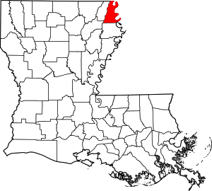 | |
| Unincorporated communities | ||
Baton Rouge (capital) | ||
| Topics |
| |
| Society |
| |
| Regions |
| |
| Cities | ||
| CDPs | ||
| Metros | ||
| Parishes | ||