Cerrillos State Forest
Cerrillos State Forest is one of the 21 state forests in Puerto Rico.[4][5] It is located in barrio Maragüez, in the municipality of Ponce, and covers 200 cuerdas (190 acres; 0.79 km2)[6] of valleys and mountains.[7] The forest has several trails, observation areas, several picnic areas, complete with gazeebos and a man-made reservoir, Lake Cerrillos and the Lake Cerrillos dam.
| Cerrillos State Forest Spanish: Bosque Estatal de Cerrillos | |
|---|---|
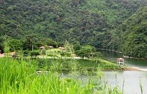 Picnic area at Cerrillos State Forest, PR-139, km 3.4 | |
| Geography | |
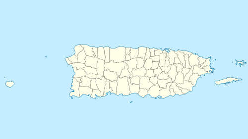 Location of Bosque Estatal de Cerrillos | |
| Location | PR-139, km. 3.4 Ponce, Puerto Rico |
| Coordinates | 18°05′18″N 66°34′50″W |
| Elevation | 1,000 feet (300 m) |
| Area | > 200 cuerdas (≈ 194 acres)[1] |
| Status | Public, State (Commonwealth) forest |
| Established | 25 September 1996[2] |
| Visitation | (2012) |
| Events | 1993 Central American and Caribbean Games 2010 Central American and Caribbean Games |
| Governing body | Puerto Rico Department of Natural and Environmental Resources |
| Website | www |
| Ecology | |
| Ecosystem(s) | Subtropical Moist Zone (Zona Húmeda Subtropical): -Tabonuco forest (Bosque de Tabonuco). |
| WWF Classification | Puerto Rican moist forests |
| Disturbance | Hurricanes[3] |
| Forest cover | 60% (approx.) |
Location
The forest is located at 18.08842 N, 66.58058 W (18°5′18.31″N 66°24′50.08″W), in barrio Maragüez, which is located northeast of the city of Ponce, Puerto Rico. It can be reached via PR-139 Km 3.4. Its elevation varies from 400 to 1,000 feet above sea level.[8]
Recreation
Recreational activities permitted in this forest include fishing, hiking, kayaking, photography, picnicking, scientific research, and bird watching.[9]
See also
References
- Bosque Estatal de Cerrillos: Refugio de Vida Silvestre Embalse Cerrillos. Hojas de Nuestro Ambiente. Puerto Rico Department of Natural and Environmental Resources. Publication P-039. April 2009. Retrieved 18 August 2013.
- Executive Order 58 of 1996 (OE-1996-58.) Government of Puerto Rico. Retrieved 18 August 2013.
- Puerto Rico Statewide Assessment and Strategies for Forest Resources. Archived 2013-03-10 at the Wayback Machine Government of Puerto Rico. Department of Natural and Environmental Resources. (n.d.; ca., 2011) Page 32. Retrieved 3 August 2013.
- Bosque Estatal de Cerrillos: Refugio de Vida Silvestre Embalse Cerrillos. Hojas de Nuestro Ambiente. Puerto Rico Department of Natural and Environmental Resources. Publication P-039. April 2009. Retrieved 16 February 2014.
- Bosques de Puerto Rico: Bosque Estatal de Toro Negro. Archived August 7, 2015, at the Wayback Machine Hojas de Nuestro Ambiente. July 2008. [Publication/Issue: P-030] Puerto Rico Department of Natural and Environmental Resources. Retrieved 29 July 2013.
- Note: 1 cuerda = 0.97122191 acre (See HERE)
- Bosque Estatal de Cerrillos: Refugio de Vida Silvestre Embalse Cerrillos. Hojas de Nuestro Ambiente. Puerto Rico Department of Natural and Environmental Resources. Publication P-039. April 2009. Retrieved 18 August 2013.
- Bosque Estatal de Cerrillos: Refugio de Vida Silvestre Embalse Cerrillos. Hojas de Nuestro Ambiente. Puerto Rico Department of Natural and Environmental Resources. Publication P-039. April 2009. Retrieved 18 August 2013.
- Bosque Estatal de Cerrillos: Refugio de Vida Silvestre Embalse Cerrillos. Hojas de Nuestro Ambiente. Puerto Rico Department of Natural and Environmental Resources. Publication P-039. April 2009. Retrieved 18 August 2013.
Further reading
- Puerto Rico Statewide Assessment and Strategies for Forest Resources. Government of Puerto Rico. Department of Natural and Environmental Resources. (n.d.; ca. 2011) 171 pages.
- Puerto Rico Statewide Assessment and Strategies for Forest Resources. Government of Puerto Rico. Department of Natural and Environmental Resources. (n.d.; ca. 2011) 100 pages.
- Guide to the Ecological Systems of Puerto Rico. Gary L. Miller and Ariel E. Lugo. United States Department of Agriculture Forest Service. International Institute of Tropical Forestry. General Technical Report IITF-GTR-35. June 2009.
- Gould, W.A.; Alarcón, C.; Fevold, B.; Jiménez, M.E.; Martinuzzi, S.; Potts, G.; Solórzano, M.; Ventosa, E. Puerto Rico Gap Analysis Project–final report. Moscow, ID: U.S. Geological Survey, and Río Piedras, PR: U.S. Department of Agriculture, Forest Service, International Institute of Tropical Forestry. 159 pages and 8 appendices. 2007.