Cerignale
Cerignale (Ligurian: Serignâ, locally Sergnâ; Piacentino: Cerignäl) is a comune (municipality) in the Province of Piacenza in the Italian region Emilia-Romagna, located about 160 kilometres (99 mi) west of Bologna and about 50 kilometres (31 mi) southwest of Piacenza. As of 31 December 2004, it had a population of 197 and an area of 31.5 square kilometres (12.2 sq mi).[3]
Cerignale | |
|---|---|
| Comune di Cerignale | |
Location of Cerignale 
| |
 Cerignale Location of Cerignale in Italy 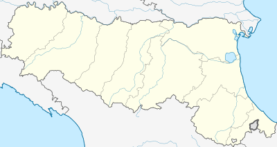 Cerignale Cerignale (Emilia-Romagna) | |
| Coordinates: 44°41′N 9°21′E | |
| Country | Italy |
| Region | Emilia-Romagna |
| Province | Province of Piacenza (PC) |
| Frazioni | Cà d'Abrà, Cariseto, Carisasca, Casale, Castello, La Serra, Lisore, Loc. Madonna, Oneto, Ponte Organasco, Rovereto, Santa Maria, Selva, Zermogliana |
| Area | |
| • Total | 31.5 km2 (12.2 sq mi) |
| Population (Dec. 2004)[2] | |
| • Total | 197 |
| • Density | 6.3/km2 (16/sq mi) |
| Demonym(s) | Cerignalesi |
| Time zone | UTC+1 (CET) |
| • Summer (DST) | UTC+2 (CEST) |
| Postal code | 29020 |
| Dialing code | 0523 |
| Website | Official website |
-castello.jpg)
the old Castle
The municipality of Cerignale contains the frazioni (subdivisions, mainly villages and hamlets) Cà d'Abrà, Cariseto, Carisasca, Casale, Castello, La Serra, Lisore, Loc. Madonna, Oneto, Ponte Organasco, Rovereto, Santa Maria, Selva, and Zermogliana.
Cerignale borders the following municipalities: Brallo di Pregola, Corte Brugnatella, Ferriere, Ottone, Zerba.
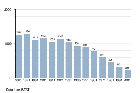
Demographic evolution
References
- "Superficie di Comuni Province e Regioni italiane al 9 ottobre 2011". Istat. Retrieved 16 March 2019.
- "Popolazione Residente al 1° Gennaio 2018". Istat. Retrieved 16 March 2019.
- All demographics and other statistics: Italian statistical institute Istat.
External links

This article is issued from Wikipedia. The text is licensed under Creative Commons - Attribution - Sharealike. Additional terms may apply for the media files.