Canas, Ponce, Puerto Rico
Canas is one of the 31 barrios in the municipality of Ponce, Puerto Rico. Along with Anón, Coto Laurel, Guaraguao, Quebrada Limón, Real, San Patricio, and Marueño, and the coastal barrio of Capitanejo, Canas is one of the municipality's nine bordering barrios. It borders the municipality of Peñuelas. Along with Playa, Bucana, Vayas and Capitanejo, Canas is also one of Ponce's five coastal barrios. It was founded in 1831.[1][lower-alpha 1]
Barrio Canas | |
|---|---|
.jpg) | |
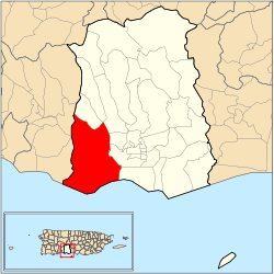 Location of barrio Canas within the municipality of Ponce shown in red | |
| Commonwealth | |
| Municipality | |
| Area | |
| • Total | 22.82 sq mi (59.1 km2) |
| • Land | 14.50 sq mi (37.6 km2) |
| • Water | 8.32 sq mi (21.5 km2) |
| Population (2000) | |
| • Total | 34,065 |
| • Density | 2,349/sq mi (907/km2) |
| Source: 2000 Census | |
Location
Canas is a suburban and partly mountainous barrio located in the southern section of the municipality, west of the city of Ponce, at latitude 18.000283N, and longitude -66.658800 W.[2]
Name

According to Sunny A. Cabrera Salcedo in this Ph.D. dissertation, the name is of native Indian origin.[3] However, according to famed Puerto Rican historian Eduardo Neumann Gandia, the name Canas comes from Palma Cana, a palm useful for making sombreros, which was very abundant in the territory of Barrio Canas.[4] Ivette Perez Vega de Soler states that Canas, more than any other barrio in Ponce, had extensive areas of "palmares de yaguas".[5] The barrio formed from a community of tobacco plant growers dating back to the 1680s.[6]
Boundaries
It is bounded on the North by the hills north of Camino Bello Road, the hills north of PR-132, and Clavel Street, on the South by the Caribbean Sea, on the West by the El Peñón de Ponce promontory, the hills west of Correccional Las Cucharas Street, and the hills west of PR-549, and on the East by the hills west of PR-123, the future western branch of PR-9, Río Pastillo (roughly) and Río Matilde (roughly).[7][8]
In terms of barrio-to-barrio boundaries, Canas is bounded in the North by the Quebrada Limón and Portugués, in the South by the Caribbean Sea, in the West by the barrios of Encarnacion, Tallaboa Saliente, and Tallaboa Alta of the municipality of Peñuelas, and in the East by Magueyes, Magueyes Urbano, Canas Urbano, and Playa.[9]
Features and demographics
.jpg)
Canas is divided into three subbarrios according to the U.S. Census Bureau: Baldorioty de Castro, Clausells, and Reparada.[10][11] The northern portion of Canas is home to the communities of Quebrada del Agua, Mansiones del Sur, Pastillo Alto, Villa Paraiso, Jardines del Caribe, Villa Delicias, Casa Mia, Villas del Caribe, Valle Alegre, and Quintas del Sur, while the southern section is host to La Cotorra,[12] Baramaya, Bello Horizonte, Las Margaritas, La Matilde, Punto Oro, Punta Diamante, El Tuque, Nueva Vida, Las Batatas, Brisas del Caribe, and Las Cucharas.[13]
Canas has 14.5 square miles (38 km2) of land area and 8.3 square miles (21 km2) of water area. In 2000, the population of Canas was 34,065 persons, and it had a density of 2,349 persons per square mile.[14] Canas, has the distinction of being the most populated barrio in the municipality of Ponce.[15] It also has the longest coastline of all barrios in Ponce.
Major roads in barrio Canas are PR-2, PR-132, PR-500, and PR-549.[16]
The highest point in Barrio Canas stands at 918 feet and is located at the northernmost tip of the barrio. Another notable land feature is the Penon de Ponce promontory near the shoreline which stands at 331 feet.[17]
Notable landmarks
Barrio Canas is home to Salinas Lagoon, a natural reserve.[18] El Tuque Beach is also located in Barrio Canas.
The Francisco Parra Duperón school is located in this barrio.[19]
See also
Notes
- Eduardo Questell Rodriguez ("Historia de la Comunidad Bélgica de Ponce: A partir de la Hacienda Muñiz y otros datos"; Ponce: PR: Mariana Editores; 2018; ISBN 978-1-935892-04-5; p.13) points out that in 1828 Pedro Tomas de Cordoba ("Memorias geográficas, históricas, y estadísticas de la Isla de Puerto Rico" Instituto de Cultura Puertorriquña. San Juan, PR. 1968. Tomo II, citado por Socorro Girón en "Ponce, el teatro La Perla y La Campana de la Almudaina". Ponce: Gobierno Municipal de Ponce. 1992, pp 10-11) listed the then-21 barrios of Ponce and his 1828 21-barrio list already included Barrio Canas, so it appears that Barrio Canas was founded in 1828, and it is even possible it may have actually been founded much earlier than 1828.
References
- Barrios de Ponce. Archived 30 September 2015 at the Wayback Machine Antepasados Esclavos.(From: Pedro Tomás de Córdoba. Memorias geográficas, históricas, económicas y estadísticas de la Isla de Puerto Rico.) Retrieved 28 November 2014.
- City Melt Retrieved, February 22, 2010.
- Sunny A. Cabrera Salcedo. Hacia un Estudio Integral de la Toponimia del Municipio de Ponce, Puerto Rico. Ph.D. dissertation. May 1999. University of Massachusetts Amherst. Graduate School. Department of Spanish and Portuguese. Page 54.
- Verdadera Y Auténtica Historia de la Ciudad de Ponce. Eduardo Neuman Gandia. Instituto de Cultura Puertorriqueña. 1913. Page 71. Accessed 16 June 2018.
- Ivette Perez Vega. Las Sociedades Mercantiles de Ponce (1816-1830). Academia Puertorriqueña de la Historia. San Juan, PR: Ediciones Puerto. 2015. pp. 60-61ISBN 9781617900563
- Luis Caldera Ortiz. Nuevos Hallazgos Sobre el Origen de Ponce. Centro de Estudios e Investigaciones del Sur Oeste de Puerto Rico. 2019. p. 65. ISBN 9781075058325
- General Purpose Population Data, Census 2000. Unidad de Sistemas de Información Geográfica, Área de Tecnología de Información Gubernamental, Oficina de Gerencia y Presupuesto. Gobierno de Puerto Rico. Archived August 12, 2010, at the Wayback Machine Retrieved February 20, 2010.
- Ponce Topographic Map. Map Styles: Map and Shaded. Trails.com. From: United States Geological Survey. Topo Map. Projection: NAD83/WGS84. Retrieved 22 February 2010.
- General Purpose Population Data, Census 2000. Unidad de Sistemas de Información Geográfica, Área de Tecnología de Información Gubernamental, Oficina de Gerencia y Presupuesto. Gobierno de Puerto Rico. Archived August 12, 2010, at the Wayback Machine Retrieved 22 February 2010.
- U.S. Census Bureau. Census 2000. Ponce and Its Barrios. (Ponce Municipio, Puerto Rico -- County Subdivision and Place. GCT-PH1. Population, Housing Units, Area, and Density: 2000. Data Set: Census 2000 Summary File 1 (SF 1) 100-Percent Data) Archived 12 February 2020 at Archive.today Retrieved March 14, 2010.
- 1990 Census of Housing. Detailed Housing Characteristics: Puerto Rico. U.S. Department of Commerce, Economics and Statistics Administration, Bureau of the Census. Archived 2010-07-17 at the Wayback Machine Retrieved March 14, 2010.
- Para noviembre la planta de reciclaje de gomas. Jason Rodríguez Grafal. La Perla del Sur. Ponce, Puerto Rico. 28 September 2011. Retrieved 28 September 2011.
- Mapa de Localizacion Limite de Barrios de Ponce. Oficina de Ordenacion Territorial. Municipio Autonomo de Ponce. Retrieved 25 March 2010.
- City Melt Retrieved, February 22, 2010.
- Barrio Canas Most Populated
- General Purpose Population Data, Census 2000. Unidad de Sistemas de Información Geográfica, Área de Tecnología de Información Gubernamental, Oficina de Gerencia y Presupuesto. Gobierno de Puerto Rico. Archived August 12, 2010, at the Wayback Machine Retrieved 18 August 2010.
- Maptest. Archived February 18, 2010, at the Wayback Machine Government of the Commonwealth of Puerto Rico. General Purpose Population Data, Census 2000. Unidad de Sistemas de Información Geográfica, Área de Tecnología de Información Gubernamental, Oficina de Gerencia y Presupuesto. Gobierno de Puerto Rico. Retrieved 10 November 2011.
- General Purpose Population Data, Census 2000. Unidad de Sistemas de Información Geográfica, Área de Tecnología de Información Gubernamental, Oficina de Gerencia y Presupuesto. Gobierno de Puerto Rico. Archived August 12, 2010, at the Wayback Machine Retrieved 22 February 2010.
- Fortuño Janiero, Luis (1963). Album Historico de Ponce (in Spanish). Ponce: Imprenta Fortuño.