Canas Urbano
Canas Urbano is one of the 31 barrios of the municipality of Ponce, Puerto Rico. Along with Machuelo Abajo, Magueyes Urbano, Portugués Urbano, and San Antón, Canas Urbano is one of the municipality's five originally rural barrios that are now also part of the urban zone of the city of Ponce. The name of this barrio is of native indigenous origin.[1] It was created in 1953.[2]
Barrio Canas Urbano | |
|---|---|
.jpg) Scene in Barrio Canas Urbano at Avenida Las Américas, looking east, near Carretera Pampanos | |
 Location of barrio Canas Urbano within the municipality of Ponce shown in red | |
| Commonwealth | |
| Municipality | |
| Area | |
| • Total | 2.31 sq mi (6.0 km2) |
| • Land | 2.31 sq mi (6.0 km2) |
| • Water | 0.00 sq mi (0.0 km2) |
| Population (2000) | |
| • Total | 21,482 |
| • Density | 9,300/sq mi (3,600/km2) |
| Source: 2000 Census | |
Location
Canas Urbano is an urban quarter located in the southern section of the municipality, within the Ponce city limits, and southwest of the traditional center of the city, Plaza Las Delicias.
Boundaries
It is bounded on the North by Ponceña Street/PR-123, by Ausencia, La Gloria, Novedades, and Idilid Streets of Morel Campos, by Ten Street of Shanghai, Villa Street/Simon Bolivar Avenue, Palo de Pan Street, Dr. Ferran Street, Ferrocarril Street, and Ramon Powell Street, on the South by PR-2, on the West by PR-132 (roughly), Río Pastillo (roughly), and Rio Canas, and on the East by Global Street, Coto Canas Street/PR-2R/Pampanos Road, and the old western branch of Rio Portugues.[3]
In terms of barrio-to-barrio boundaries, Canas Urbano is bounded in the North by Magueyes Urbano, Portugués Urbano, Segundo, Primero, and Cuarto, in the South by Canas and Playa, in the West by Canas, and San Anton, and in the East by Segundo, Primero, and San Anton.
Features and demographics
Canas Urbano has 2.3 square miles (6.0 km2) of land area and no water area. In 2000, the population of Canas Urbano was 21,482 persons, and it had a density of 9,301 persons per square mile.[4]
The communities of Jardines del Caribe (first and second sections only), Morel Campos, Shanghai, Aristides Chavier, Baldorioty, San Antonio, Rio Canas, Los Maestros, Santa Maria, Perla del Sur, Villa Grillasca, and Reparto Universitario are found here. Villa Grillasca was built in the 1950s and consisted of 720 duplex-style homes.[5]
Notable landmarks
Barrio Canas Urbano is home to the Juan Pachín Vicéns Auditorium, Francisco Montaner Stadium, and the Pontifical Catholic University of Puerto Rico and various other important landmarks.
Gallery
.jpg) Italian restaurant on Calle Concordia, near Avenida Las Américas
Italian restaurant on Calle Concordia, near Avenida Las Américas.jpg) Italian restaurant on Calle Concordia near Avenida Las Américas
Italian restaurant on Calle Concordia near Avenida Las Américas.jpg)
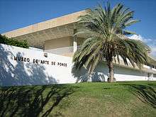
 Interior of Museo de Arte de Ponce on Avenida Las Américas
.jpg) Universidad Católica on Avenida Las Américas
Universidad Católica on Avenida Las Américas.jpg) Ponce YMCA Building in Urbanización Santa María
Ponce YMCA Building in Urbanización Santa María
See also
References
- Sunny A. Cabrera Salcedo. Hacia un Estudio Integral de la Toponimia del Municipio de Ponce, Puerto Rico. Ph. D. dissertation. May 1999. University of Massachusetts Amherst. Graduate School. Department of Spanish and Portuguese. Page 54.
- Barrios de Ponce. Archived 30 September 2015 at the Wayback Machine Antepasados Esclavos.(From: Pedro Tomás de Córdoba. Memorias geográficas, históricas, económicas y estadísticas de la Isla de Puerto Rico.) Retrieved 28 November 2014.
- General Purpose Population Data, Census 2000. Unidad de Sistemas de Información Geográfica, Área de Tecnología de Información Gubernamental, Oficina de Gerencia y Presupuesto. Gobierno de Puerto Rico. Archived August 12, 2010, at the Wayback Machine Retrieved February 20, 2010.
- City Melt Retrieved, February 20, 2010.
- Carmelo Rosario Natal. Ponce En Su Historia Moderna: 1945-2002. Published by Secretaría de Cultura y Turismo of the Government of the Autonomous Municipality of Ponce. Ponce, Puerto Rico. 2003. p. 48.
- U.S. Geological Survey Geographic Names Information System: Canas Urbano Barrio