Camooweal Caves National Park
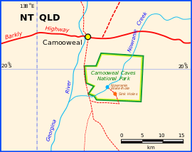
Camooweal Caves is a national park in Queensland, Australia, 15 km southeast of Camooweal and 1720 km northwest of Brisbane.[1]
| Camooweal Caves National Park Queensland | |
|---|---|
IUCN category II (national park) | |
 Camooweal Caves National Park | |
 Camooweal Caves National Park | |
| Coordinates | 20°3′0″S 138°11′4″E |
| Established | 1988 |
| Area | 138 km2 (53.3 sq mi) |
| Website | Camooweal Caves National Park |
| See also | Protected areas of Queensland |
Description
The national park consists of 13,800 hectares of eucalypt woodland, spinifex, wattle and Mitchell grass. Accessible to the public are two sinkholes that formed over 500 million years by water seepage through beds of dolomite. A picnic table is provided at Nowranie waterhole.[2]
History
The wider Camooweal area was inhabited by the Indjalandji-Dhidhanu People for thousands of years before the arrival of the Europeans in 1860s. The aboriginal people utilised the park area and the Georgina River for trade with their tribal neighbours. Till date, the Indjalandji-Dhidhanu People believe that the route is traversed by Dreamings, the routes covered by ancestral spirits who shaped the landscape. The Dreamings have created various sites of significance to the Indjalandji-Dhidhanu People in the park.[3]
See also
References
- Hema, Maps (2007). Australia Road and 4WD Atlas (Map). Eight Mile Plains Queensland: Hema Maps. p. 12. ISBN 978-1-86500-456-3.
- "Queensland Government National Parks, Sport and Racing". Archived from the original on 21 April 2016. Retrieved 7 April 2016.
- "Culture and history". Parks and Forests Queensland Government.